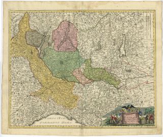
Antique Print - ITALY - DUCHY OF MILAN - PARMA - PIEDMONT - SAVOY - Bonne - 1787
Item History & Price
The Prints Collector
Original Antique Maps and PrintsABOUT USVISIT OUR STOREAntique Print-ITALY-DUCHY OF MILAN-PARMA-PIEDMONT-SAVOY-Bonne-1787
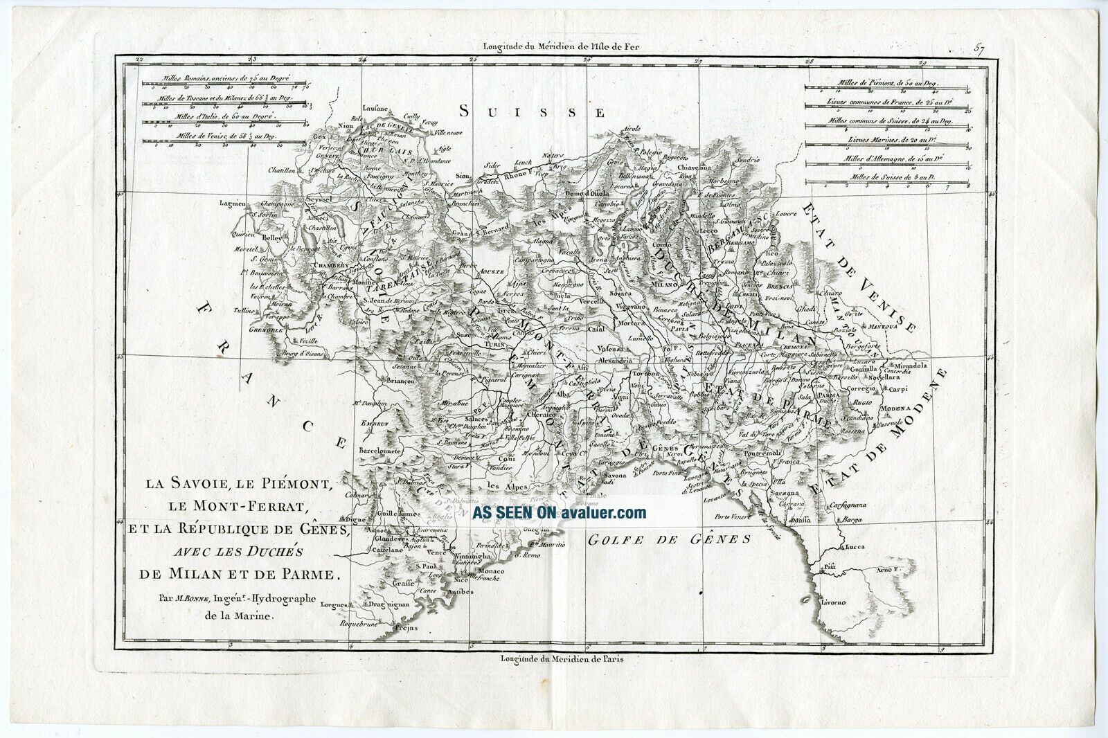
Description: Atlas encyclopedique, contenant la geographie ancienne et quelques cartes (…) by Rigobert Bonne and Nicolas Desmarest, published in France 1787.
Artists and Engravers: Made by an anonymous engraver after 'Bonne'.Subject: Antique print, titled: 'La Savoie, Le Piemont, Le Mont-Ferrat, Et la Republique De Genes, Avec... Les Duches De Milan et de Parme (…).' - Handsome detailed regional map of northern Italy.
Condition: Good, given age. A few minor crinkles/light small creases. Original middle fold as issued. General age-related toning and/or occasional minor defects from handling. Please study scan carefully.
Size (in cm): The overall size is ca. 42.2 x 28 cm. The image size is ca. 34.3 x 24.3 cm.
Size (in inch): The overall size is ca. 16.6 x 11 inch. The image size is ca. 13.5 x 9.6 inch.
Medium: Copperplate engraving/etching on hand laid (verge) paper.
Location: PCOM-A8-13
ThePrintsCollector - Laurentius Old Master Prints
Frans Laurentius, Peter Cornelissen
Margo van Latum-van Dongen, Frank van Latum
Located in Zeeland (Noord-Brabant) - The Netherlands
Worldwide free shipping on all orders.
We ship within three business days upon receipt of payment.
We ship by registered mail.
GO TO OUR STORE and explore our huge collection of fine antique maps and prints. We only accept payments via Paypal.
Combined orders are possible! We will send a Paypal invoice on request!
THE PRINTSCOLLECTOR GUARANTEES ITEMS SOLD THROUGH EBAY ARE GENUINE ORIGINAL
ANTIQUE PRINTS IN THE CONDITION/TECHNIC AS DESCRIBED. ITEMS CAN BE RETURNED WITHIN 30 DAYS.
Original Antique Maps and PrintsABOUT USVISIT OUR STOREAntique Print-ITALY-DUCHY OF MILAN-PARMA-PIEDMONT-SAVOY-Bonne-1787
Description: Atlas encyclopedique, contenant la geographie ancienne et quelques cartes (…) by Rigobert Bonne and Nicolas Desmarest, published in France 1787.
Artists and Engravers: Made by an anonymous engraver after 'Bonne'.Subject: Antique print, titled: 'La Savoie, Le Piemont, Le Mont-Ferrat, Et la Republique De Genes, Avec... Les Duches De Milan et de Parme (…).' - Handsome detailed regional map of northern Italy.
Condition: Good, given age. A few minor crinkles/light small creases. Original middle fold as issued. General age-related toning and/or occasional minor defects from handling. Please study scan carefully.
Size (in cm): The overall size is ca. 42.2 x 28 cm. The image size is ca. 34.3 x 24.3 cm.
Size (in inch): The overall size is ca. 16.6 x 11 inch. The image size is ca. 13.5 x 9.6 inch.
Medium: Copperplate engraving/etching on hand laid (verge) paper.
Location: PCOM-A8-13
ThePrintsCollector - Laurentius Old Master Prints
Frans Laurentius, Peter Cornelissen
Margo van Latum-van Dongen, Frank van Latum
Located in Zeeland (Noord-Brabant) - The Netherlands
Worldwide free shipping on all orders.
We ship within three business days upon receipt of payment.
We ship by registered mail.
GO TO OUR STORE and explore our huge collection of fine antique maps and prints. We only accept payments via Paypal.
Combined orders are possible! We will send a Paypal invoice on request!
THE PRINTSCOLLECTOR GUARANTEES ITEMS SOLD THROUGH EBAY ARE GENUINE ORIGINAL
ANTIQUE PRINTS IN THE CONDITION/TECHNIC AS DESCRIBED. ITEMS CAN BE RETURNED WITHIN 30 DAYS.