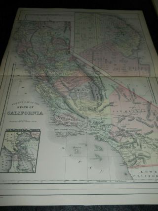
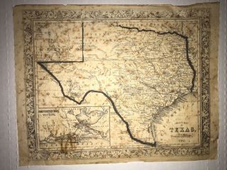
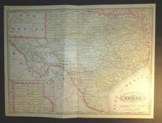
Antique 1887 County Map Of Texas 22 X 15 " Map Very Colorful


Item History & Price

Information:
Reference Number: Avaluer:30797446Cartographer/Publisher: A. R. Keller
Type: County MapPrinting Technique: Unknown
Year: 1887Original/Reproduction: Antique Original
Date Range: 1800-1899Format: Atlas Map
Country/Region: United States of America
Original Description:
Offered in this listing is an antique 1887 2 page centerfold county map of the state of Texas. Copyright 1887 by Wm. M. Bradley & Bros, and taken from Mitchell's 1893 New General Atlas, Publisher A. R. Keller. This 22 x 15" map remains quite colorful and in very nice condition. Please refer to my additional listings for more antique maps of collectible interest!


    Similar items


  • Antique 1887 County Map Of California 22 X 15 " Map Very Colorful

    Antique 1887 County Map Of California 22 X 15 " Map Very Colorful

  • 1906 Geo F Cram Railroad And County Map Of Virginia 22 " X 14” W/inset Of Norfolk

    1906 Geo F Cram Railroad And County Map Of Virginia 22 " X 14” W/inset Of Norfolk

  • Antique 1887 Plan Map Of Orleans 11 X 13 " Map Very Colorful

    Antique 1887 Plan Map Of Orleans 11 X 13 " Map Very Colorful

  • Antique 1887 Plan Map Of Baltimore 11 X 13 " Map Very Colorful

    Antique 1887 Plan Map Of Baltimore 11 X 13 " Map Very Colorful

  • Antique 1860 County Map Of Texas Scarce

    Antique 1860 County Map Of Texas Scarce

  • Geo.  F.  Cram

    Geo. F. Cram ' S " Railroad & County Map Of Texas " 23 - 1/4 " X 17 - 3/8 ", C1880 - 90s

  • 1906 Geo F Cram Railroad And County Color State Map Of York 22 " X 14 "

    1906 Geo F Cram Railroad And County Color State Map Of York 22 " X 14 "

  • 1906 Geo F Cram Railroad And County Color State Map Of Alabama 22 " X 14 "

    1906 Geo F Cram Railroad And County Color State Map Of Alabama 22 " X 14 "


    • You might also like


    • 1860 Mitchell Hand Colored Map Colorado,  Nebraska & Kansas - Civil War Era

      1860 Mitchell Hand Colored Map Colorado, Nebraska & Kansas - Civil War Era

    • 18th Century French Map Of North America

      18th Century French Map Of North America

    • Las Vegas Nevada Vintage 1967 Us Geological Survey Quadrangle Map 4 Panels

      Las Vegas Nevada Vintage 1967 Us Geological Survey Quadrangle Map 4 Panels

    • Rare Antique 1845 Maps United States Exploring Expedition Book Antartica Hawaii

      Rare Antique 1845 Maps United States Exploring Expedition Book Antartica Hawaii

    • Vintage 1926 Map Hollywood From The Best Surveys Of The Time

      Vintage 1926 Map Hollywood From The Best Surveys Of The Time

    • American Continent (western Hemisphere) 1747 Bowen Antique Copper Engraved Map

      American Continent (western Hemisphere) 1747 Bowen Antique Copper Engraved Map

    • Gulf Coast Florida Texas United States 1705 De Fer Unusual Antique Engraved Map

      Gulf Coast Florida Texas United States 1705 De Fer Unusual Antique Engraved Map

    • California As Island United States 1700 De Fer Unusual First Edition Antique Map

      California As Island United States 1700 De Fer Unusual First Edition Antique Map

Avaluer          About Us          Privacy Policy          Contact Us          UP
© 2022, avaluer.net, Inc. or its affiliates