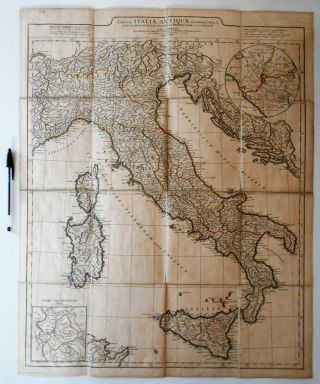
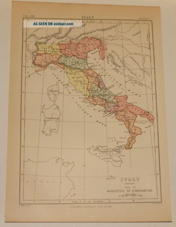
Old Map Of Italy In The Roman Era (1880)


Item History & Price

Information:
Reference Number: Avaluer:30984082Printing Technique: Unknown
Year: 1883Original/Reproduction: Antique Original
Date Range: 1800-1899Format: Book page
Era: 1800sType: State Map
Original Description:
Just to be clear: this is a map, from an 1879 publication, showing Italy as it was in the time of the emperors Augustus to Constantine, 27.5cm x 19.0cm.  


    Similar items


  • 1922 Map Of Africa In The Colonial Era By Meyers.  Vintage

    1922 Map Of Africa In The Colonial Era By Meyers. Vintage

  • 1900 Map Of Siberia In The Czarist Era By Meyers

    1900 Map Of Siberia In The Czarist Era By Meyers

  • 1764 D

    1764 D ' Anville Map Of Italy In Roman Times Geography History Europe Colour

  • Illustrated Maps Of Scotland In The 17th Century - 95 Pages Of Very Old Maps

    Illustrated Maps Of Scotland In The 17th Century - 95 Pages Of Very Old Maps

  • Victorian Era Child

    Victorian Era Child ' S Wool Dress & Old Photograph Of Child In The Dress

  • Antique Map Of England Within The Roman Empire During The Reign Of Antonius Pius

    Antique Map Of England Within The Roman Empire During The Reign Of Antonius Pius

  • Old Map Of Evansville,  In From 1888 - Vintage Indiana Art,  Historic Decor

    Old Map Of Evansville, In From 1888 - Vintage Indiana Art, Historic Decor

  • 1902 Map Of Italy By The Century Company.  Antique

    1902 Map Of Italy By The Century Company. Antique


    • You might also like


    • Hungary & Romania 1579 (1584) Ortelius Unusual Antique Copper Engraved Map

      Hungary & Romania 1579 (1584) Ortelius Unusual Antique Copper Engraved Map

    • Brussels Bruxelles Belfium 1777 De Ferraris & Dupuis Large Antique Map Sheet Xxi

      Brussels Bruxelles Belfium 1777 De Ferraris & Dupuis Large Antique Map Sheet Xxi

    • 1616 Atlas Map Of Iceland.

      1616 Atlas Map Of Iceland.

    • Kazan Russia 1767 Le Clerc/lespinasse Antique Copper Engraved City View

      Kazan Russia 1767 Le Clerc/lespinasse Antique Copper Engraved City View

    • 1899 Stanford,  Folding Map Of Norwich,  Norfolk,  Arthur Collins,  Jarrold & Sons,

      1899 Stanford, Folding Map Of Norwich, Norfolk, Arthur Collins, Jarrold & Sons,

    • 1948 Vintage Linen Colour Map Geological Survey Ten Mile Of Great Britain

      1948 Vintage Linen Colour Map Geological Survey Ten Mile Of Great Britain

    • 1944 Map Flying Bombs Sussex Ww2 Newspaper Military Kent Courier German V1 V2

      1944 Map Flying Bombs Sussex Ww2 Newspaper Military Kent Courier German V1 V2

    • Dated 1638 Vellum Map Of Icklesham Sussex Showing Land Uses Owners Etc

      Dated 1638 Vellum Map Of Icklesham Sussex Showing Land Uses Owners Etc

Avaluer          About Us          Privacy Policy          Contact Us          UP
© 2022, avaluer.net, Inc. or its affiliates