Antique Survey Map Florida With Keys / United States Coast Survey 1848 - 1855


Item History & Price

Information:
Reference Number: Avaluer:34141Type: Map
US State: FloridaDate Range: 1800-1899
Original/Reproduction: OriginalYear: 1848
Maker: Browne & Hasbrouck Lith, NYCountry/Region: United States of America
UPC: Does not apply
Original Description:
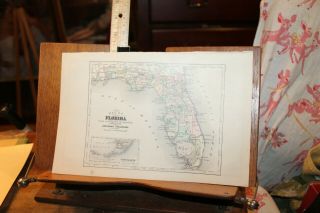
Florida Coast Survey Map, 1848-1855
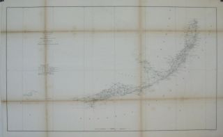
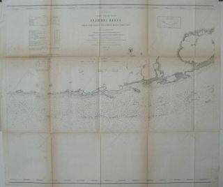
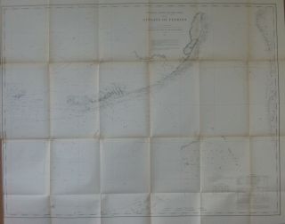
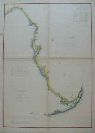
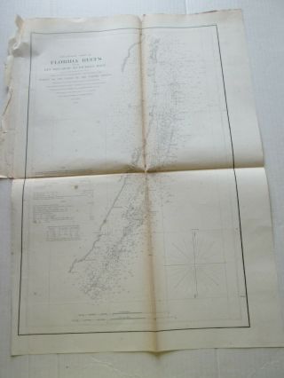
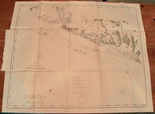
"U.S. Coast Survey"  "Sketch F Showing the Progress of the Survey in Section VI" "With a General Reconnaissance of the Coast of Florida" Excellent condition antique map with period tinting / coloring "Browne & Hasbrouck Lith, NY" United States Coastal Survey in scale 1/1200000 Detailed views of Tortugas Island ans St. John's River 23" Tall by 16 1/2" Wide Folds appear to be excellent condition Map shows only only slight soiling and mino...r foxing


    Similar items


  • 1861 Coast Survey Map Florida Reefs Key West Miami River Dry Tortugas

    1861 Coast Survey Map Florida Reefs Key West Miami River Dry Tortugas

  • 1856 Coast Survey Map Florida Reefs Key Biscayne Lighthouses Beacons

    1856 Coast Survey Map Florida Reefs Key Biscayne Lighthouses Beacons

  • 1863 Us Coast Survey Map Florida Reefs Key Largo Long Island Matecumbe

    1863 Us Coast Survey Map Florida Reefs Key Largo Long Island Matecumbe

  • 1868 Coast Survey Map Florida Keys Biscayne Bay Dry Tortugas Havana

    1868 Coast Survey Map Florida Keys Biscayne Bay Dry Tortugas Havana

  • 1852 Coast Survey Map Florida West Coast Keys Indian District Tampa Bay

    1852 Coast Survey Map Florida West Coast Keys Indian District Tampa Bay

  • (1) 1856 U.  S.  Coast Survey Chart: Florida Reefs,  Key Biscayne To Pickles Reef

    (1) 1856 U. S. Coast Survey Chart: Florida Reefs, Key Biscayne To Pickles Reef

  • 1862 Us Coast Survey Map Florida Reefs Newfound Harbor Key To Boca Grande Key

    1862 Us Coast Survey Map Florida Reefs Newfound Harbor Key To Boca Grande Key

  • Antique 1885 Map Florida And The Florida Keys

    Antique 1885 Map Florida And The Florida Keys


    • You might also like


    • 1860 Mitchell Hand Colored Map Colorado,  Nebraska & Kansas - Civil War Era

      1860 Mitchell Hand Colored Map Colorado, Nebraska & Kansas - Civil War Era

    • 18th Century French Map Of North America

      18th Century French Map Of North America

    • Las Vegas Nevada Vintage 1967 Us Geological Survey Quadrangle Map 4 Panels

      Las Vegas Nevada Vintage 1967 Us Geological Survey Quadrangle Map 4 Panels

    • Rare Antique 1845 Maps United States Exploring Expedition Book Antartica Hawaii

      Rare Antique 1845 Maps United States Exploring Expedition Book Antartica Hawaii

    • Vintage 1926 Map Hollywood From The Best Surveys Of The Time

      Vintage 1926 Map Hollywood From The Best Surveys Of The Time

    • American Continent (western Hemisphere) 1747 Bowen Antique Copper Engraved Map

      American Continent (western Hemisphere) 1747 Bowen Antique Copper Engraved Map

    • Gulf Coast Florida Texas United States 1705 De Fer Unusual Antique Engraved Map

      Gulf Coast Florida Texas United States 1705 De Fer Unusual Antique Engraved Map

    • California As Island United States 1700 De Fer Unusual First Edition Antique Map

      California As Island United States 1700 De Fer Unusual First Edition Antique Map

Avaluer          About Us          Privacy Policy          Contact Us          UP
© 2022, avaluer.net, Inc. or its affiliates