C. 1843 NORTH AMERICA With REPUBLIC OF TEXAS - SDUK, ANTIQUE HAND - COLORED MAP


Item History & Price
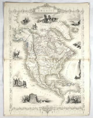
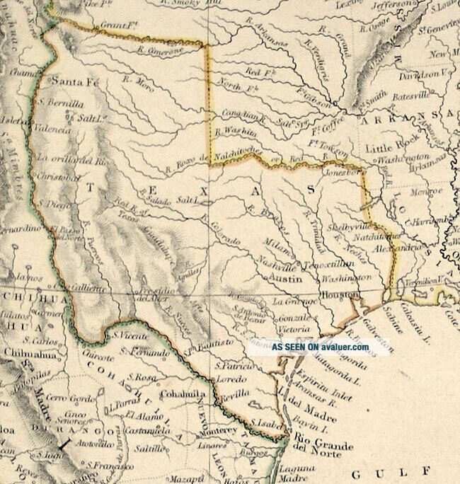
Original Antique Map of North America, c. 1843
Independent Republic of Texas
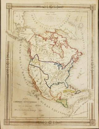
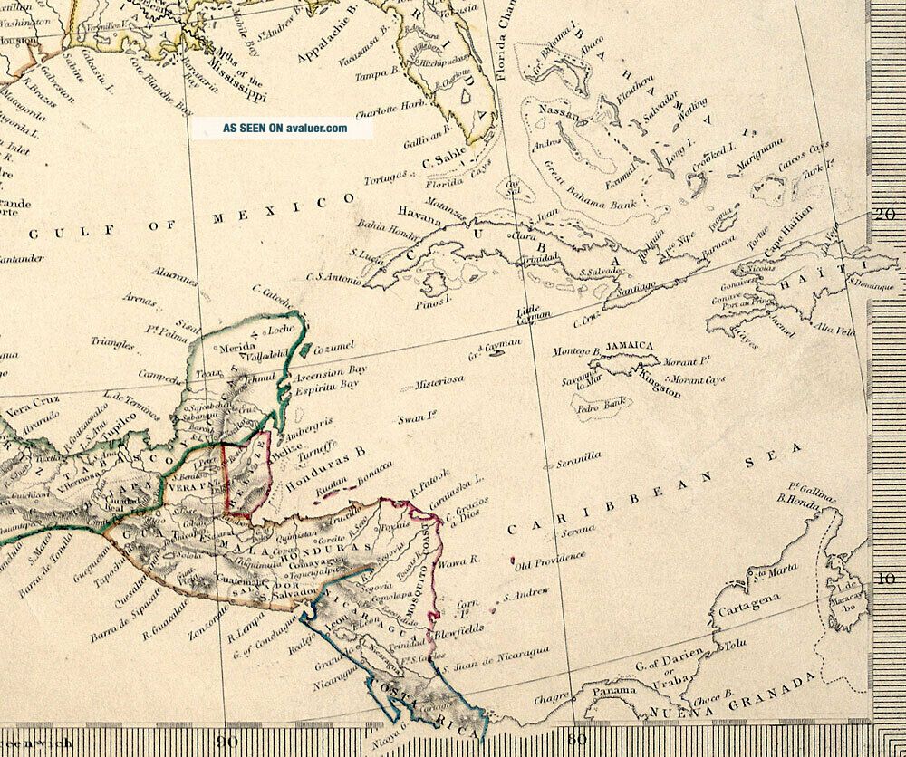
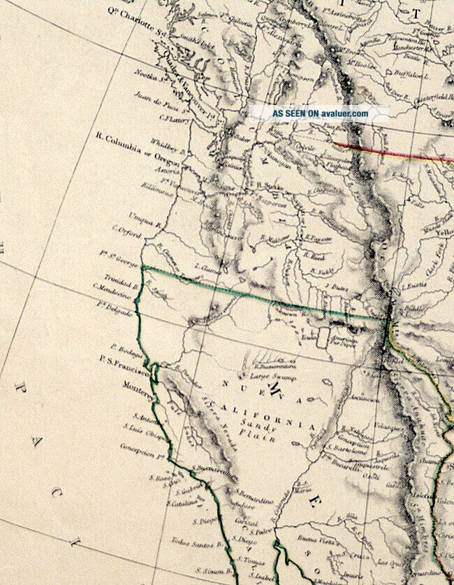
M-14313: “NORTH AMERICA” London: Society for the Diffusion of Useful Knowledge, dated 1843, published by Chapman & Hall. Engraved map with original outline color. (Ref: Wheat #463; Phillips #794). (Paper size: 16 1/8 x 13 1/8’’ – Size from border edges: 15 1/8 x 12 1/8’’).
This detailed historical map shows North America at a particular...ly interesting and changing period. The vast territorial claims of the Independent Republic of Texas extend north along the Rio Grande to the Arkansas River (an area included in Texas’ boundaries until the Compromise of 1850). The region from the Rio Grande to the Pacific is shown under Mexican Rule, and present-day Alaska under the Russian flag. The United States was in the process of western exploration and expansion (the area west of Wisconsin and Iowa territory is unnamed - with the exception of “Columbia” in the upper northwest which was claimed by both the British and Americans until 1846, and shown here with no distinct boundary). Many Indian Tribes are located, and major towns, cities and water routes are identified throughout the continent.
This is an original, not a reproduction, and its condition is good as shown in the photos.
This map comes with a Certificate of Authenticity.
We prefer payment through PayPal. For international purchase we accept only PayPal. Ohio residents should add 6.75% sales tax. Shipping in the United States is $8.00 via USPS Priority Mail. Outside US, shipping is $39.00 by secure Registered Mail. International Buyers – Please Note: Import duties, taxes, and charges are NOT INCLUDED in the item price or shipping cost. These charges are the buyer's responsibility. Please check with your country's customs office to determine what these additional costs will be prior to bidding or buying.
We have been full-time dealers in Illuminated Manuscripts, Maps, Prints and Antiquities since 1980.
Independent Republic of Texas
M-14313: “NORTH AMERICA” London: Society for the Diffusion of Useful Knowledge, dated 1843, published by Chapman & Hall. Engraved map with original outline color. (Ref: Wheat #463; Phillips #794). (Paper size: 16 1/8 x 13 1/8’’ – Size from border edges: 15 1/8 x 12 1/8’’).
This detailed historical map shows North America at a particular...ly interesting and changing period. The vast territorial claims of the Independent Republic of Texas extend north along the Rio Grande to the Arkansas River (an area included in Texas’ boundaries until the Compromise of 1850). The region from the Rio Grande to the Pacific is shown under Mexican Rule, and present-day Alaska under the Russian flag. The United States was in the process of western exploration and expansion (the area west of Wisconsin and Iowa territory is unnamed - with the exception of “Columbia” in the upper northwest which was claimed by both the British and Americans until 1846, and shown here with no distinct boundary). Many Indian Tribes are located, and major towns, cities and water routes are identified throughout the continent.
This is an original, not a reproduction, and its condition is good as shown in the photos.
This map comes with a Certificate of Authenticity.
We prefer payment through PayPal. For international purchase we accept only PayPal. Ohio residents should add 6.75% sales tax. Shipping in the United States is $8.00 via USPS Priority Mail. Outside US, shipping is $39.00 by secure Registered Mail. International Buyers – Please Note: Import duties, taxes, and charges are NOT INCLUDED in the item price or shipping cost. These charges are the buyer's responsibility. Please check with your country's customs office to determine what these additional costs will be prior to bidding or buying.
We have been full-time dealers in Illuminated Manuscripts, Maps, Prints and Antiquities since 1980.