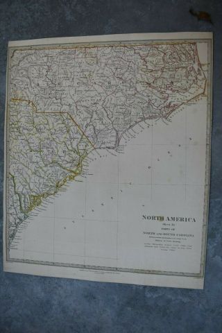
19th Century Map Of North And South Carolina Published By J Hinton 1832


Item History & Price

Information:
Reference Number: Avaluer:35532Cartographer/Publisher: J Hinton
Type: World AtlasPrinting Technique: steel engraving
Year: 1832Original/Reproduction: Antique Original
US State: South Carolina North CarolinaFormat: Folding Map
Era: 1832
Original Description:
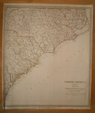
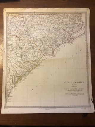
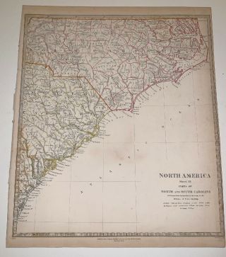
"Mapof the states of North and South Carolina"
FromJohn H. Hinton's The History and Topography of the United States ofAmerica. London: I.T. Hinton & Simpkin & Marshall, [1830]-1832. Steel engraving by Fenner Sears & Co.
Alovely example of a steel engraving from one of the more popularnineteenth century view and map books, Hinton's History andTopography. This work contained text and numerous illustrationsdocumenting the history and topography of the United States. Hin...tonused many different artists, all the engravings being made fromdrawings made on the spot. For their wide coverage, accurate detail, and pleasing appearance, these are amongst the finest small images ofearly nineteenth century America to be found anywhere. The Londonedition was the only one with maps of the regions throughout theUnited States.
PaperSize Measures 28 cm x 40.5 cm
Readyfor Framing


    Similar items


  • 1833 Sduk: Map Of North And South Carolina

    1833 Sduk: Map Of North And South Carolina

  • Antique Map Of North And South Carolina Georgia By Bellin From 1757

    Antique Map Of North And South Carolina Georgia By Bellin From 1757

  • Vintage Map Automobile Roads Of North And South Carolina 1929 Gulf Oil Petrolian

    Vintage Map Automobile Roads Of North And South Carolina 1929 Gulf Oil Petrolian

  • 19th Century Map Of Missouri And Illinois Published By J Hinton 1832

    19th Century Map Of Missouri And Illinois Published By J Hinton 1832

  • Map North America Sheet Xi Parts Of North And South Carolina 1833

    Map North America Sheet Xi Parts Of North And South Carolina 1833

  • 1833 Sduk Map Of Parts Of North And South Carolina - Sheet Xi

    1833 Sduk Map Of Parts Of North And South Carolina - Sheet Xi

  • 1833 Baldwin Cradock Map America North And South Carolina Antique

    1833 Baldwin Cradock Map America North And South Carolina Antique

  • 1849 Radefeld Meyer Map Of North And South America -

    1849 Radefeld Meyer Map Of North And South America -


    • You might also like


    • 1860 Mitchell Hand Colored Map Colorado,  Nebraska & Kansas - Civil War Era

      1860 Mitchell Hand Colored Map Colorado, Nebraska & Kansas - Civil War Era

    • 18th Century French Map Of North America

      18th Century French Map Of North America

    • Las Vegas Nevada Vintage 1967 Us Geological Survey Quadrangle Map 4 Panels

      Las Vegas Nevada Vintage 1967 Us Geological Survey Quadrangle Map 4 Panels

    • Rare Antique 1845 Maps United States Exploring Expedition Book Antartica Hawaii

      Rare Antique 1845 Maps United States Exploring Expedition Book Antartica Hawaii

    • Vintage 1926 Map Hollywood From The Best Surveys Of The Time

      Vintage 1926 Map Hollywood From The Best Surveys Of The Time

    • American Continent (western Hemisphere) 1747 Bowen Antique Copper Engraved Map

      American Continent (western Hemisphere) 1747 Bowen Antique Copper Engraved Map

    • Gulf Coast Florida Texas United States 1705 De Fer Unusual Antique Engraved Map

      Gulf Coast Florida Texas United States 1705 De Fer Unusual Antique Engraved Map

    • California As Island United States 1700 De Fer Unusual First Edition Antique Map

      California As Island United States 1700 De Fer Unusual First Edition Antique Map

Avaluer          About Us          Privacy Policy          Contact Us          UP
© 2022, avaluer.net, Inc. or its affiliates