Historical Antique Map, 1894, Colton ' S Map Of York Wilderness & Adirondacks


Item History & Price

Information:
Reference Number: Avaluer:3867021Cartographer/Publisher: WW Ely
Year: 1894Printing Technique: Lithography
US State: New YorkOriginal/Reproduction: Antique Original
Date Range: 1800-1899Format: Folding Map
Country/Region: United States of AmericaType: County Map
Original Description:
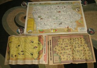
This is a very nice antique map entitled:  Colton's Map of the New York Wilderness and the Adirondacks, dated 1894.  It was compiled by W.W. Ely, MD. and revised by Edwin R. Wallace.  The map is in fine condition and measures 29" x 33".  Nice size.  Please, check out the pictures for condition and characteristics.  We are available for questions or further photos.
# Pictures are part of the description.  Contact us with any questions you mighthave....# POSTAGE:  Wehave lost a lot of money on postage.  Our SHIPPING IS HIGH.We will REFUNDan amount which gives the buyer over a $1 or more, after mailing!#We WILL BUNDLE shipping on multiple items! # WE COLLECT 9% Sales Tax for California Residents.# Contact us if you want us to ship internationally.  We will consider it based on the item.Our store (http://stores.ebay.com/TJRRBAA)has a HUGE variety of different items. Check them out! 


    Similar items


  • 1930 Paris France Uncommon Pictorial Map - Antique Vintage Historic

    1930 Paris France Uncommon Pictorial Map - Antique Vintage Historic

  • 1855 Kansas (kanzas) & Nebraska Territory Antique Map Jh Colton & Co,  York

    1855 Kansas (kanzas) & Nebraska Territory Antique Map Jh Colton & Co, York

  • Vintage 1946 The Des Moines Register Sunday Newspaper Iowa Map &1977 Historical

    Vintage 1946 The Des Moines Register Sunday Newspaper Iowa Map &1977 Historical

  • 1920 Map - World War 1 - Poland,  Historical

    1920 Map - World War 1 - Poland, Historical

  • Rare 1876 Atlas Somerset County Pa F W Beers & Co Geneology Historical

    Rare 1876 Atlas Somerset County Pa F W Beers & Co Geneology Historical

  • Rare 1873 Atlas Somerset County Nj F W Beers & Co Genealogy Historical

    Rare 1873 Atlas Somerset County Nj F W Beers & Co Genealogy Historical

  • Antique Map,  1894 Plan Of Baltimore Maryland Md,  A.  L.  Smith; Framed

    Antique Map, 1894 Plan Of Baltimore Maryland Md, A. L. Smith; Framed

  • Antique Map " Louisiana " Colton

    Antique Map " Louisiana " Colton ' S Atlas Of The World


    • You might also like


    • 1860 Mitchell Hand Colored Map Colorado,  Nebraska & Kansas - Civil War Era

      1860 Mitchell Hand Colored Map Colorado, Nebraska & Kansas - Civil War Era

    • 18th Century French Map Of North America

      18th Century French Map Of North America

    • Las Vegas Nevada Vintage 1967 Us Geological Survey Quadrangle Map 4 Panels

      Las Vegas Nevada Vintage 1967 Us Geological Survey Quadrangle Map 4 Panels

    • Rare Antique 1845 Maps United States Exploring Expedition Book Antartica Hawaii

      Rare Antique 1845 Maps United States Exploring Expedition Book Antartica Hawaii

    • Vintage 1926 Map Hollywood From The Best Surveys Of The Time

      Vintage 1926 Map Hollywood From The Best Surveys Of The Time

    • American Continent (western Hemisphere) 1747 Bowen Antique Copper Engraved Map

      American Continent (western Hemisphere) 1747 Bowen Antique Copper Engraved Map

    • Gulf Coast Florida Texas United States 1705 De Fer Unusual Antique Engraved Map

      Gulf Coast Florida Texas United States 1705 De Fer Unusual Antique Engraved Map

    • California As Island United States 1700 De Fer Unusual First Edition Antique Map

      California As Island United States 1700 De Fer Unusual First Edition Antique Map

Avaluer          About Us          Privacy Policy          Contact Us          UP
© 2022, avaluer.net, Inc. or its affiliates