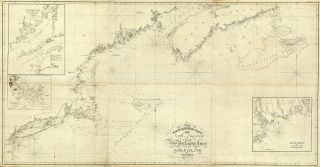
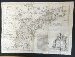
1834 SDUK: North America - Index Map To Canada And The United States


Item History & Price

Information:
Reference Number: Avaluer:3909478Original/Reproduction: Antique Original
US State: AL, FL, GA, MS, NC, SC, AR, IA, KS, LA, MO, NE, MichiganYear: 1834
Date Range: 1800-1899
Original Description:
From "Society for Diffusion of Useful Knowledge"A beautifully hand-colored map from "Society for the Diffusion of Useful Knowledge"The Society for the Diffusion of Useful Knowledge (SDUK), founded in 1826, and wound up in 1848, was a Whiggish London organisation that published inexpensive texts intended to adapt scientific and similarly high-minded material for the rapidly expanding reading public. It was established mainly at the instigation of Lord Brougham with the objects of publishing infor...mation to people who were unable to obtain formal teaching, or who preferred self-education.
Atlas title : Maps of the Society for the Diffusion of Useful Knowledge.Map title : SEE MAPPublished : London :1833Language : English
Wear : wear as seen in photos 
Size: ~13.5in X 16in (33cm x 41cm)


    Similar items


  • Shadowrun Neo Anarchist

    Shadowrun Neo Anarchist ' S The Guide To North America With Map Rare 1991

  • Shadowrun The Neo - Anarchist

    Shadowrun The Neo - Anarchist ' S Guide To North America W/map

  • 1828 Map Ne Coast North America,  N.  Y.  To Cape Canso Nautical Chart Wall Poster

    1828 Map Ne Coast North America, N. Y. To Cape Canso Nautical Chart Wall Poster

  • Spv

    Spv ' S Comprehensive Railroad Atlas Of North America Index To North East Usa

  • Complete Guide To Hunting Across North America 1970 - Maps Of Game By State

    Complete Guide To Hunting Across North America 1970 - Maps Of Game By State

  • 1895 Antique Central School House Supply North America Relief Map

    1895 Antique Central School House Supply North America Relief Map

  • 1804 Map Of The United States - Of North America

    1804 Map Of The United States - Of North America

  • 1755 Map Of British & French Settlements In North America

    1755 Map Of British & French Settlements In North America


    • You might also like


    • 1860 Mitchell Hand Colored Map Colorado,  Nebraska & Kansas - Civil War Era

      1860 Mitchell Hand Colored Map Colorado, Nebraska & Kansas - Civil War Era

    • 18th Century French Map Of North America

      18th Century French Map Of North America

    • Las Vegas Nevada Vintage 1967 Us Geological Survey Quadrangle Map 4 Panels

      Las Vegas Nevada Vintage 1967 Us Geological Survey Quadrangle Map 4 Panels

    • Rare Antique 1845 Maps United States Exploring Expedition Book Antartica Hawaii

      Rare Antique 1845 Maps United States Exploring Expedition Book Antartica Hawaii

    • Vintage 1926 Map Hollywood From The Best Surveys Of The Time

      Vintage 1926 Map Hollywood From The Best Surveys Of The Time

    • American Continent (western Hemisphere) 1747 Bowen Antique Copper Engraved Map

      American Continent (western Hemisphere) 1747 Bowen Antique Copper Engraved Map

    • Gulf Coast Florida Texas United States 1705 De Fer Unusual Antique Engraved Map

      Gulf Coast Florida Texas United States 1705 De Fer Unusual Antique Engraved Map

    • California As Island United States 1700 De Fer Unusual First Edition Antique Map

      California As Island United States 1700 De Fer Unusual First Edition Antique Map

Avaluer          About Us          Privacy Policy          Contact Us          UP
© 2022, avaluer.net, Inc. or its affiliates