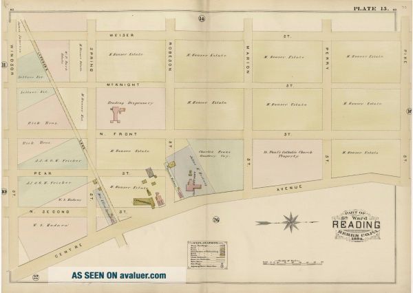
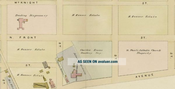
1884 READING BERKS COUNTY PA. CHARLES EVANS CEMETERY WINDSOR - PIKE ST ATLAS MAP


Item History & Price

Information:
Reference Number: Avaluer:42482372
Original Description:
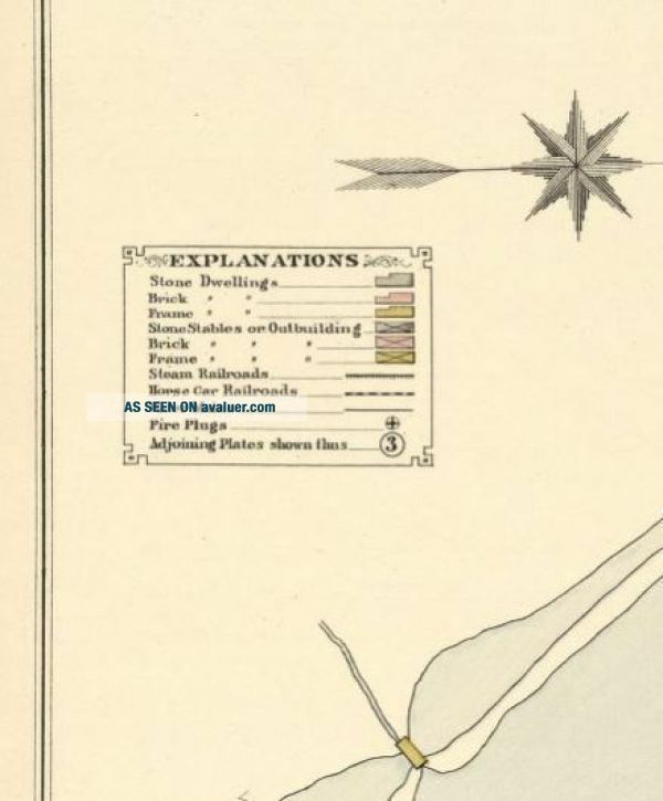
This is a 24x36 high quality, high resolution reproduction on 70 lb. thick stock paper (see my feedback)  of an 1884 A.H. Mueller plat atlas map of Reading, Pennsylvania in Berks County (6th Ward). It includes the Charles Evans Cemetery, St. Paul's Catholic Church Property and Andalusia Hotel.  It is in Mint condition.Plate 15: covers from Weiser St. to Centre Ave. and from Windsor St. to Pike St.Each color represents adifferent type of building: Grey is Stone;... Pink is Brick and Yellow is Wood. Grey Box with an X = Stone Stable or Outbuilding; Pink Boxwith an X = Brick Stable or Outbuilding and Yellow Box with an X = Wood Stable or Outbuilding. See key forwhat all the symbols indicate.Other sizes available upon request:  11x14, $19.95; 16x20, $24.95; 20x24, $29.95; 36x48, $69.95; 24x36.MOUNTED ON FOAM BOARD: 11X14, $24.95; 16X20, $39.95; 20X24, $49.95; 24X36, $59.95.I am selling my collection of raremaps.  If there is a street address of Manhattan, Brooklyn, Queens, Bronx, Staten Island, Long Island, Rochester, Syracuse, Buffalo, Elmira, MonroeCounty, NY, Newark, Atlantic City, Essex County, Montgomery County, MorrisCounty, Bergen County, Cleveland, Toledo, Youngstown, Kansas City, Washington, D.C., New Haven, Bridgeport, Toronto, Montreal, Vancouver, Portland, Maine, Seattle, Los Angeles, Denver, Boston, South Boston, Dorchester, Roxbury, Everett, Worcester, Pawtucket, Brookline, Quincy, Newton, Malden, Lawrence, Lynn, Fitchburg, Middlesex County, Philadelphia, Pittsburgh, Harrisburg, Wilkes-Barre, Reading, Berks County, Delaware County, Montgomery County, Newport & Providence, Rhode Island and other cities that you are interestedin, please check out my other listings or contact me.  I have insurance maps from 1880 to mid-1950s.  Looks great framed! Check out my otheritems!  Besure to add me to your favorites list! 

00331


    Similar items


  • Reading,  Berks County,  Pa 1854 Property Deed - Pennsylvania Document

    Reading, Berks County, Pa 1854 Property Deed - Pennsylvania Document

  • The Passing Scene By George M.  Meiser Reading Berks County Pa 10 Volumes 1 - 10

    The Passing Scene By George M. Meiser Reading Berks County Pa 10 Volumes 1 - 10

  • Centreport (pa) Centennial 1884 - 1984 Berks County Pa Hard Cover Book 722

    Centreport (pa) Centennial 1884 - 1984 Berks County Pa Hard Cover Book 722

  • Centreport Centennial 1884 - 1984 Berks County Pa,  History Of Centreport,  Pa

    Centreport Centennial 1884 - 1984 Berks County Pa, History Of Centreport, Pa

  • Centreport Centennial 1884 - 1984 Berks County Pa Hard Cover Book

    Centreport Centennial 1884 - 1984 Berks County Pa Hard Cover Book

  • Vol 1 Thru 12 The Passing Scene Meiser History Of Reading & Berks County Pa

    Vol 1 Thru 12 The Passing Scene Meiser History Of Reading & Berks County Pa

  • 1968 Book - Boy Scouts Bsa - Daniel Boone Council - Reading,  Berks County,  Pa

    1968 Book - Boy Scouts Bsa - Daniel Boone Council - Reading, Berks County, Pa

  • Vtg Sign Plaque Member Chamber Of Commerce Reading Berks County Pa Pagoda

    Vtg Sign Plaque Member Chamber Of Commerce Reading Berks County Pa Pagoda


    • You might also like


    • 1860 Mitchell Hand Colored Map Colorado,  Nebraska & Kansas - Civil War Era

      1860 Mitchell Hand Colored Map Colorado, Nebraska & Kansas - Civil War Era

    • 18th Century French Map Of North America

      18th Century French Map Of North America

    • Las Vegas Nevada Vintage 1967 Us Geological Survey Quadrangle Map 4 Panels

      Las Vegas Nevada Vintage 1967 Us Geological Survey Quadrangle Map 4 Panels

    • Rare Antique 1845 Maps United States Exploring Expedition Book Antartica Hawaii

      Rare Antique 1845 Maps United States Exploring Expedition Book Antartica Hawaii

    • Vintage 1926 Map Hollywood From The Best Surveys Of The Time

      Vintage 1926 Map Hollywood From The Best Surveys Of The Time

    • American Continent (western Hemisphere) 1747 Bowen Antique Copper Engraved Map

      American Continent (western Hemisphere) 1747 Bowen Antique Copper Engraved Map

    • Gulf Coast Florida Texas United States 1705 De Fer Unusual Antique Engraved Map

      Gulf Coast Florida Texas United States 1705 De Fer Unusual Antique Engraved Map

    • California As Island United States 1700 De Fer Unusual First Edition Antique Map

      California As Island United States 1700 De Fer Unusual First Edition Antique Map

Avaluer          About Us          Privacy Policy          Contact Us          UP
© 2022, avaluer.net, Inc. or its affiliates