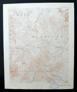
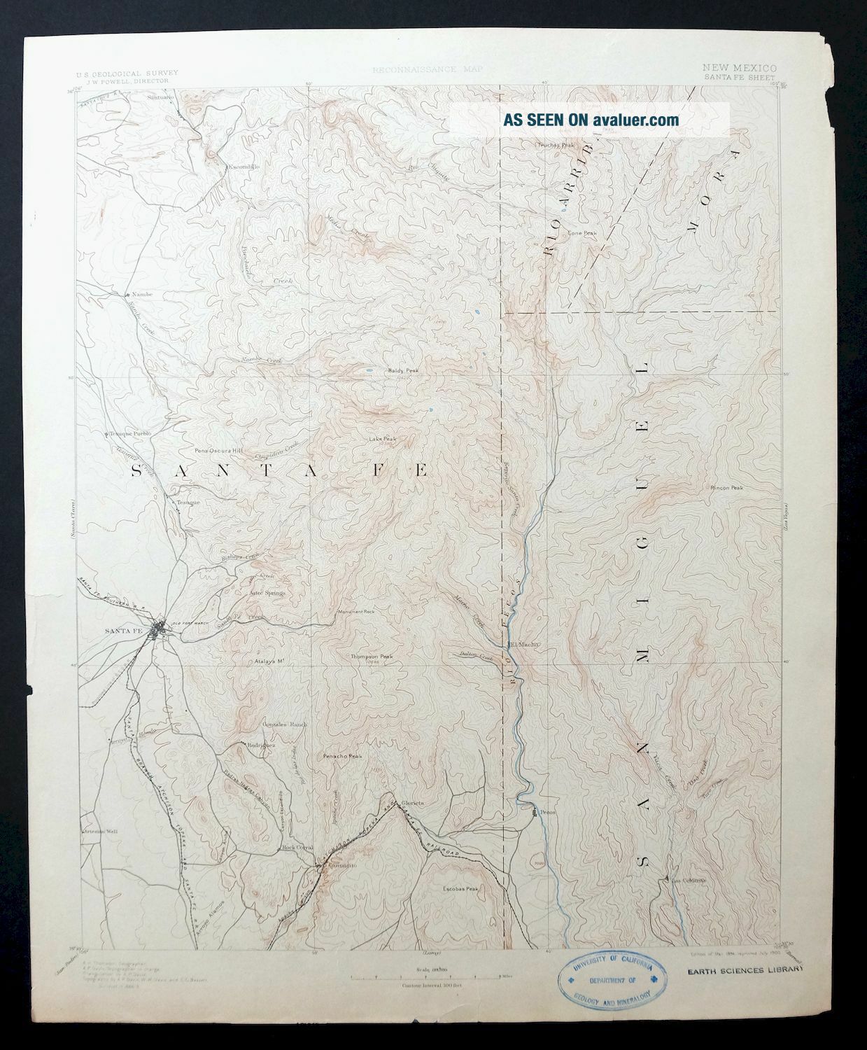
Santa Fe Mexico Rare Antique USGS Topo Map 1894 Pecos Agua Fria
Item History & Price
SANTA FE NEW MEXICO MAP 1894 Vintage Cartographics New Mexico Maps ∙ Antique Prints ∙ Bargain Bin ∙ Browse Nearby Sheets 1894
Santa Fe
New Mexico
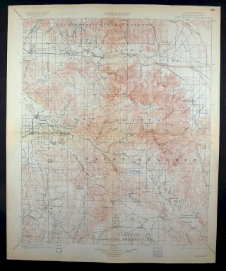
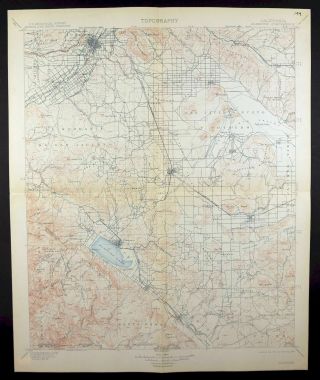
USGS RECONNAISSANCE TOPO MAP
1900 print in good condition
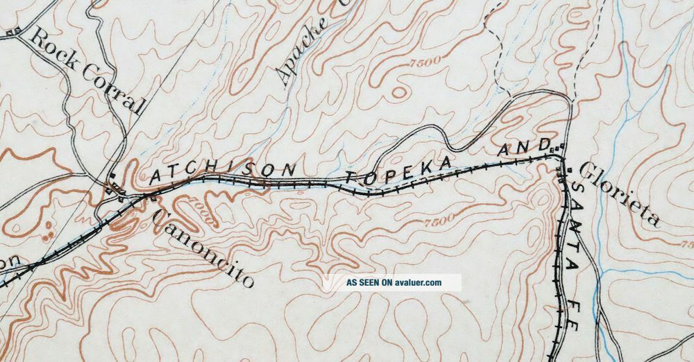
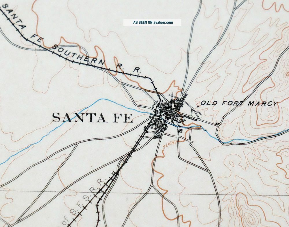
For sale is the 1894 edition of the Santa Fe 30-minute map. This map would be great for framing or display, historical reference or re...search, genealogy studies, adding to a collection, treasure hunting, a nice conversation piece, a gift for a history or map enthusiast, or for anyone interested in this area. This sheet includes the only survey done by the United States Geological Survey for the Santa Fe 30-minute quadrangle. The map is an original 1900 USGS print. The sheet is 119 years old and is in good condition. The Santa Fe map was surveyed before aerial photography methods were widely used in map data gathering. It was drawn by Geological Survey cartographers based on plane table field survey information as well as information gathered from local residents in the area. It displays the remarkable abilities of the early USGS map makers, who placed a strong emphasis on creating complete, accurate, and cartographically appealing maps. MAP DETAILS Title Santa Fe State New Mexico Series 30-minute Surveyed 1888 and 1889 Field Survey Geographer A.H. Thompson Edition 1894 Printed 1900, thick paper stock Woodland Tint No Scale 1:125000 Contour Interval 100 Foot Sheet Dimensions 16 x 20 inches (approximate) Map Dimensions 14 1/4 x 17 1/2 inches Coverage Area Roughly 28 x 32 miles Notes surveyed 23 years before New Mexico statehood, this sheet is a fascinating historical snapshot of Santa Fe when its population was around 5000 and transport was by rail line SHEET CONDITION For maps of this vintage, effort is made to note all visible flaws, no matter how minor. Overall Condition GOOD Sheet Notes lightly handled, never folded, lightly age-toned sheet Map Area no markings, no blemishes Collar Area no markings, no blemishes, repaired edge tears and wear along edges, inventory stamp on lower collar MAP COVERAGE Quadrangle extent overlaid on current basemap. Browse Nearby
Sheets PLACENAMES Depending on map series and survey date, all of the features listed below may not be shown on this map. This list contains features that currently exist or historically existed within the area covered by this map. The list can be used as a reference to determine if this map covers your area of interest. Placenames are listed alphabetically next to each feature type. Cities and Towns (current) Agua Fria, Canada de los Alamos, Canoncito, Chimayo, Chupadero, Cowles, Cundiyo, Eldorado at Santa Fe, Glorieta, La Puebla, Lamy, Nambe, Pecos, Pojoaque, Rio Chiquito, Rio en Medio, Santa Fe, Tererro, Tesuque, and Tesuque Pueblo Counties Covered Mora, Rio Arriba, San Miguel, and Santa Fe Federal Land Units Carson National Forest, Nambe Indian Reservation, Pecos National Historical Park, Pecos Wilderness, Pojoaque Indian Reservation, Santa Fe National Forest, and Tesuque Indian Reservation Rivers and Streams Agua Sarca, Alamo Creek, Arroyo de la Cañada Ancha, Arroyo de la Morada, Arroyo de los Chamisos, Arroyo de los Guardunos, Arroyo Hondo, Arroyo Seco, Aztec Springs Creek, Bear Creek, Beaver Creek, Bonanza Creek, Bull Creek, Calabasa Arroyo, Carpenter Creek, Cave Creek, Cienega Creek, Cow Creek, Daily Creek, Davis Creek, Doctor Creek, El Rito, Elk Creek, Galisteo Creek, Gallina Arroyo, Gallinas River, Glorieta Creek, Hagen Creek, Holy Ghost Creek, Horsethief Creek, Indian Creek, Jacks Creek, Maestas Creek, Manuelitas Creek, Middle Fork Rio Santa Barbara, North Fork Rio Quemado, Panchuela Creek, Pecos River, Pojoaque River, Rio de la Cebolla, Rio de las Trampas, Rio Frijoles, Rio la Casa, Rio Medio, Rio Nambe, Rio Quemado, Rio Santa Barbara, Rio Tesuque, Rio Valdez, Rito Azul, Rito Chaperito, Rito con Agua, Rito de la Osha, Rito de las Quemazones, Rito de los Alamitos, Rito de los Chimayosos, Rito del Oso, Rito del Padre, Rito Frijoles, Rito Gallina, Rito la Vega, Rito Las Trampas, Rito los Esteros, Rito Maestas, Rito Manzanares, Rito Oscuro, Rito Perro, Rito Quemado, Rito Quemazon, Rito Ruidoso, Rito San Jose, Rito Sebadilloses, Rito Torito, San Marcos Arroyo, Santa Cruz River, Santa Fe River, Sapello River, Sawyer Creek, Sheep Creek, Soldier Creek, South Fork Bear Creek, South Fork Rio Casa, South Fork Rio Quemado, South Fork Rito Azul, Tecolote Creek, Wild Horse Creek, Willow Creek, and Winsor Creek Water Bodies Lake Katherine, McClure Reservoir, San Leonardo Lakes, Santa Fe Lake, Stewart Lake, and Twomile Reservoir Populated Places: Canada de los Alamos, Chupadero, Cowles, Cundiyo, East Pecos, El Dorado, El Dorado at Santa Fe, El Macho, Eldorado at Santa Fe, En Medio, Escondillo, Geronimo, Glorieta, Grass Mountain Summer Home Area, Holy Ghost, La Cueva, La Loma, La Puebla, Lower Colonias, Lower La Posada, Nambe, Nambe Pueblo, Pecos, Potrero, Rancho Encantado, Rio En Medio, Santa Fe, Seton Village, Tererro, Tesuque, Tesuque Pueblo, Tres Lagunas, Upper Colonias, Upper La Posada, and Winsor Creek Summer Home. Post Offices: Glorieta Post Office, La Loma Post Office, Pecos Post Office, Santa Fe Post Office, and Tesuque Post Office. Locations: 297 Valencia Interchange, Aspen Basin Recreation Area, Aspen Cabin, Aspen Forrest Service Station, Aspen Ranch, Aspen Vista Picnic Area, BLM Recreation Site, Barrio de Analco Historic District, Beatty Cabin, Bert Clancy Recreation Site, Big Tesuque Campground, Bishops Lodge, Black Canyon Forest Camp, Borrego Mesa Campground, Bouquet Ranch Historic Site, Boy Scouts of America Chimayo Rest Camp, Brazos Cabin, Brush Ranch, Camino del Monte Sol Historic District, Camp Frank Rand Boy Scout Camp, Camp La Salle, Camp Stony, Canoncito, Canoncito Siding, Canoncito at Apache Canyon, Chimayo Boy Scout Camp, Conklin Estate, Cow Creek Campground, Cowles Campground, Cowles Weather Station, Don Gaspar Historic District, El Rancho Montoso, El Rancho Viejo Historic Site, El Rancho de San Sebastian, Eldorado at Santa Fe, Emerson Ranch, Evergreen Lodge, Field Tract Campground, Flying Cloud Ranch, Forked Lightning Ranch, Fort Marcy Ruins Historic Site, Gallina Camp, Garcia Ranch, Glorieta Battlefield National Historic Landmark, Glorieta Convention Center, Glorieta Pass Battlefield Historic Site, Glorieta Pass Ranch, Glorieta Picnic Area, Glorieta Weather Station, Gonzales Ranch, Hidden Valley Ranch, Holy Ghost Campground, Holy Ghost Summer Home Area, Honey Boy Ranch, Hyde Park Estates, Iron Gate Recreation Site, Jacks Creek Campground, Kay Bar Ranch, Laboratory of Anthropology, Lisboa Springs Fish Hatchery, Little Tesuque Camp, Loyd Ranch, Lynch Ranch, Manzanares Cabin, Manzanares Campground, Martin Ranch, Martyrs Cross, Monastery Lake Recreation Site, Mora Campground, Nambe, Nambe Archaeological District, Ninemile Ranch, Northlake Campground, Ortiga Ranch, Overlook Campground, Padre Spring Ranch, Panchuela Campground, Panchuela Ranger Station, Panchuela West Cabin, Pecos District Ranger Station, Pecos Weather Station, Prince Plaza, Rancho Encantado, Rancho La Merced, Rancho Viejo, Rancho la Barbarria, Romero Ranch, Santa Fe Archery Club, Santa Fe Fast Base, Santa Fe Historic District, Santa Fe Ski Basin, Santa Fe Weather Station, Sena Plaza, Seton Village National Historic Landmark, Sierra Lodge, Smith Cabin, Sol y Sombra, Trading Post, Valencia Ranch Archaeological, Willow Creek Campground, Windy Bridge Recreation Site, and Winsor Creek Recreation Site. Areas: Horsethief Meadow, Panchuela West, Rincon Bonito, Valle Alto, Valle Escondido, Valle Largo, Valle Medio, Valle de la Osha, Valle de la Piedra, Valle del Toro, and Vegas Bonita. Administrative Boundaries: Alexander Valle Grant, Canada De Los Alamos Grant, Cuyamungue Grant, Juan de Gabaldon Grant, Nambe Pueblo Grant, Pecos Pueblo, Salvador Gonzales, Santa Cruz Grant, Santa Fe Grant, Santiago Ramirez Grant, Santo Domingo De Cundiyo Grant, Sebastian de Vargas Grant, Talaya Hill Grant, and Tesuque Pueblo Grant. Mountain Ranges: Santa Fe Mountains. Mountains, Peaks, and Summits: Aspen Peak, Atalaya Mountain, Mount Barker, Mesa Borrego, Chaperito Knob, Chimayosos Peak, The Dome, Elk Mountain, Cerro de Escobas, Fangio Mesa, Glorieta Baldy, Glorieta Mesa, Cerro Gordo, Granite Point, Grass Mountain, Hamilton Mesa, Lake Peak, Middle Truchas Peak, Monument Rock, Sierra Mosca, North Truchas Peak, Cerrito del Padre, Pecos Baldy, Pena Oscura Hill, Penitente Peak, Cerro Pinon, Redonda peak, Rosilla Peak, Round Mountain, Rowe Peak, Santa Fe Baldy, Shaggy Peak, Spring Mountain, Sun Mountain, Talaya Hill, Tano Point, Tesuque Peak, Thompson Peak, Truchas Peak, and Viveash Mesa. Reserves: Nambe Indian Reservation, Santa Fe Municipal Watershed, and Tesuque Indian Reservation. Arroyos and Washes: Arroyo de la Canada Ancha, Arroyo Barranca, Arroyo Cuma, Arroyo de los Guardunos, Arroyo de los Lovatos, Arroyo Mascaras, Arroyo de la Morada, Arroyo de la Piedra, Arroyo Ranchito, Arroyo del Rosario, Arroyo Saiz, Arroyo San Antonio, Arroyo Seco, Arroyo Tenorio, Arroyo Tierra Blanca, and Arroyo Torreon. Valleys and Canyons: Alamitos Canyon, Canada Ancha, Canada Ancha, Canada Ancha, Canyon Ancho, Apache Canyon, Canon Chimayo, Canon Cola y Largo, Canada Corral, Canon Corrales, Canon de Cuervito, La Cueva Canyon, Canon de la Cueva, Dalton Canyon, Dry Gulch, Glorieta Canyon, Grasshopper Canyon, Hartman Canyon, Jarosa Canyon, Macho Canyon, Canon de la Madera, Canon de Manzanita, Canada de las Minas, Arroyo Mora, Canon Navajo, Canon Ojo Sarco, Canon del Oso, Pacheco Canyon, Piedras Negras Canyon, Canada Rincon, Ruiz Canyon, Canon de Tijeras, Canon de lo Trigos, and Canada Vaca. Parks: Amelia White Park, Ashbaugh Park, Atalaya Park, Atchison Topeka and Santa Fe Railway Depot Locomotive 5030 Historic Site, Candelero Park, Cerro Gordo Park, Cornell Park, Dalton Picnic Area, De Vargas Park, Fort Marcy Park, Frank S Ortiz Park, General Franklin E Miles Park, Glorieta Pass Historical Marker, Gregory Lopez Park, Herb Martinez Park, Hillside Park, Hyde Memorial State Park, John F Ray Griego Park, Larragoite Park, Magers Field, Monica Lucero Park, O'Bannon Field, Orlando Fernandez Park, Pecos Historical Marker, Pecos National Historical Park, Pecos National Monument Historical Marker, Pecos State Monument, Pecos Wilderness, Pueblo of Nambe Historical Marker, Pueblo of Tesuque Historical Marker, Ragle Park, Salvador Perez Park, Santa Fe Recreation Area, Santa Fe River Park, Santa Fe River Park East, Santa Fe River Park West, Santa Fe River State Park, Santa Fe Trail Historical Marker, Santa Fe on the Camino Real, Seton Village Historical Marker, Southridge Calle Lorca Park, The Santa Fe Plaza National Historic Landmark, Torreon Park, and Young Park. Drainages: Rito con Agua, Rito sin Agua, Albright Creek, Canada de Amole, Rito Atascoso, Aztec Springs Creek, Rito Azul, Bear Creek, Beatty Creek, Bull Creek, Rito Canejo, Rio Capulin, Carpenter Creek, Cave Creek, Rito Chaperito, Rito de los Chimayosos, Rio Chupadero, Chupaderos Creek, Rito Cola y Largo, Davis Creek, Deer Creek, Doctor Creek, Elk Creek, Rito los Esteros, Rio Frijoles, Rito Frijoles, Rito Gallina, Glorieta Creek, Hagen Creek, Holy Ghost Creek, Horsethief Creek, Indian Creek, Jacks Creek, Rito Jaroso, Rito Las Trampas, Little Tesuque Creek, Rito Maestas, Rito Manzanares, Rio Medio, Rio en Medio, Rio Molino, Rio Mora, Rio Nambe, Noisy Brook, North Fork Tesuque Creek, Rito Oscuro, Rito de la Osha, Rito del Oso, Rito del Padre, Panchuela Creek, Rito Perro, Puertecito Creek, Rio Quemado, Rito Quemado, Rito Quemazon, Rito de las Quemazones, Rito Cola Largo, Rito Ruidoso, Agua Sarca Creek, Agua Sarca, Sawyer Creek, Rito Sebadilloses, Sheep Creek, Soldier Creek, South Fork Bear Creek, South Fork Rito Azul, South Fork Tesuque Creek, Tesuque Creek, Rito Torito, Rio Valdez, Rito la Vega, Wild Horse Creek, Willow Creek, and Winsor Creek. Mines: Cowles, Cundiyo, Fairview Lode Mine, Faith, Gilliland Claims, Gould and Thomas Mine, Guy Number One, High Peak, Hubbard Prospect, Jones Mine, Kennedy, Kunklin, Marion, Paytiano, Pecos Mine, Santa Fe Manganese District, and Santa Rita Beryl Prospect. Churches: Apostolic Revival Tabernacle United Pentacostal, Archbishop Lamys Chapel Historic Site, Ba'hai Faith Church, Baptist Indian Center, Benedictine Monastery, Berean Baptist Church, Bible Baptist Church, Bible Life Church, Calvary Baptist Church, Calvary Chapel, Capilla de Santo Domingo Church, Capital Christian Church, Capital City Church of Christ, Cathedral Missions, Chapel of San Miguel Historic Site, Christ Evangelical Church, Christ Lutheran Church, Christian Covenant Church, Christian Life Fellowship, Christian Science Reading Room, Church of Christ, Church of Religous Science, Cristo Rey Catholic Church, Cristo Rey Church, Dial Meditation and Prayer Church, El Buen Pastor Church, El Santuario Church National Historic Landmark, English Speaking SDA Church, First Church of the Nazarene, Glorieta Baptist Church, Grace Community Church, I Am Sanctuary Church, La Capilla de Nacimiento del Nino Dios Church, Living Word Church, Lutheran Church of the Servant, Marcy Park Seventh Day Adventist Church, Mount Carmel Chapel, Mountain Cloud Zen Center, Nuestra Senora de la Luz Church, Office of Governmental Ministry LCA, Our Lady of Guadalupe Church, Our Lady of Light Chapel Historic Site, Our Lady of Light Church Historic Site, Reridos of Our Lady of Light, Rodeo Road Baptist Church, Sacred Heart Church, Saint Anne Catholic Church, Saint Annes Church, Saint Bedes Episcopal Church, Saint Dominic Church, Saint Elias the Prophet Orthodox Church, Saint John the Baptist Catholic Church, Saint Johns United Methodist Church, San Antonio de la Ladera Church, San Diego Church, San Francisco de Assisi Church, San Miguel Mission, San Ysidro Church, Sangre De Cristo Novitiate, Sant Michaels Chapel, Santa Maria De La Paz Catholic Community, Santo Nino Church, Santuario De Gaudalupe, Scottish Rite Temple, Spanish Assembly of God Church, Spanish Baptist Church, Temple Baptist, Temple Beth Shalom, The Celebration Church, The Church of Antioch, The Church of Jesus Christ of Latter Day Saints, The Living Word Church, The Salvation Army Church, Tres Campos Presbyterian Church USA, Westminster Presbyterian Church, and Zia United Methodist Church. Hospitals: Health centers of Northern New Mex La Loma Clinic, Pecos Valley Medical Center, Pinon Hills Hospital, Rio Valle Recover center, and Saint Vincent Hospital. Lakes and Ponds: Lake Johnson, Jose Vigil Lake, Lake Katherine, Lost Bear Lake, Lost Lake, Middle Fork Lake, Monastery Lake, Nambe Lake, Santa Fe Lake, Spirit Lake, Stewart Lake, Trampas Lakes, and Truchas Lakes. Canals: Acequia de los Pinos, La Puebla Ditch, Potrero Ditch, and Reservoir Ditch. Crossings: 294 Canoncito Interchange and 299 Glorieta Interchange. Dams: McClure Dam, Nambe Falls Dam, Nichols Dam, Santa Cruz Debris Basin Number 101 Dam, Santa Cruz Reservoir Dam, and Two Mile Reservoir Dam. Buildings: Alexis Hall, Allison Dormitory Historic Site, Alumni Hall, A M Bergere House Historic Site, Archdiocese Library, Atchison Topeka and Santa Fe Railway Depot Santa Fe Historic Site, Benildus Hall, Benjamin M Read House Historic Site, Bookstop Branch Library, Borrego House Historic Site, Boyle House Historic Site, Campus Bookstore, Carlos Vierra House Historic Site, Catancach House Historic Site, Center for Academic Development, Christian Brothers Residence, Cienega Village Museum, College of Santa Fe Fogelson Library Center, Connells Cabin Historic Site, Connor Hall, Dendahl House Historic Site, Digneo-Valdez House Historic Site, Donaciano Vigil House Historic Site, Dorman House Historic Site, Dorothy S McKibben House Historic Site, Dudrow House Historic Site, El Patio Building Historic Site, El Zaguan Historic Site, Minerals and Natural Resource Library Energy, Environmental Improvement Divison Library, Evans Science Laboratory, Felipe Delgado House Historic Site, Fogelson Library, Fogelson Library Forum/Computer Center, Fogelson Library Southwest Annex/Art Gallery, Fort Marcy Officers Residence Historic Site, Francisca Hinojos House Historic Site, Garson Communication Center, George Cuyler Preston House Historic Site, Glorieta Baptist Conference Center, Greer Garson Thearte Center, Gregorio Crespin House Historic Site, Harriet Naylor Memorial Collection on Volunteerism, Hayt-Wientage Mansion Historic Site, Hesch House Historic Site, Hilario Gallegos House Historic Site, Institute of American Indian Arts, Institute of American Indian Arts Ceramics Studio, Institute of American Indian Arts Studio, John F Kennedy Hall, Jose Alarid House Historic Site, Jose D Sena House Historic Site, Juan Holmes House Historic Site, Juan Jose Prada House, La Salle Hall, Laboratory of Anthropology Library, Marcos and Nicolasa Guterierrez House Historic Site, Martin Luther King Junior Residence Hall, Meem Library, Mr and Mrs William Field Residence Historic Site, Museum of Fine Arts Library, Museum of International Folk Art, Museum of International Folk Art Library, Museum of New Mexico, New Mexico Corrections Department Library, New Mexico Department of Education Library, New Mexico Governors Mansion, New Mexico Legislative Council Service Library, New Mexico School for the Deaf Library, New Mexico State Capitol, New Mexico State Engineer Library, New Mexico State Highway Department, New Mexico State Highway and Transportation Department Library, Old Federal Building Historic Site, Old Palace of the Governors, Oliver LaFarge Branch Library, Onate Center, Ortiz Y Pino House, Ortiz y Ortiz Residence Historic Site, Padre Gallegos House Historic Site, Peter Van Dresser House Historic Site, Peterson Student Center, Pinckney R Tully House, Professor J A Wood House, Randall Davey House Historic Site, Ricardo Alarid House Historic Site, Rio Grande Depot Historic Site, Roque Lobato House, Saint Johns College Library, Saint Michaels Residence Hall, Sandoval House, Santa Fe Builders Supply Company Building Historic Site, Santa Fe Community College Buisness Assistance Center Library, Santa Fe Community College Learning Resource Center Library, Santa Fe County Courthouse Historic Site, Santa Fe Opera, School of American Research Library, Seton Castle Historic Site, Shellaberger Tennis Center, Southwestern College Library, Spanish Log Cabin Historic Site, State Records and Archives Library, Stone Warehouse, Supreme Body Shop Historic Site, Supreme Court Law Library, Tesuque Valley Fire Station, Trinidad Chaves House Historic Site, United States Courthouse Historic Site, Weigle Hall, and Wheelwright Museum. Bridges: Bridge of the Hidalgos Historic Site. Basins: Aspen Basin. Ridges: Bordo Del Medio, La Cueva Ridge, Cerros Negros, Sierra Pelada, Ruidoso Ridge, and Trailriders Wall. Reservoirs and Tanks: Four Mile Reservoir, Granite Point Reservoir, McClure Reservoir, Nambe Falls Reservoir, Nambe Reservoir, Nichols Reservoir, Nombe Reservoir, Santa Cruz Lake, Sierra Mosca Trick Tank, Tesuque Pueblo Reservoirs, and Twomile Reservoir. Swamps: Cienega Redonda. Towers: Glorieta Baldy Lookout Tower Historic Site, KIOT-FM (Espanola), KKOB-AM (Santa Fe), KSFR-FM (Santa Fe), KSWV-AM (Santa Fe), KTRC-AM (Santa Fe), and KVSF-AM (Santa Fe). Trails: Agua Sarca Trail, Alpine Ski Trail, Atalaya Trail, Avalanche Bowl Ski Trail, Azmataz Ski Trail, Bear Wallow Trail, Big Tesuque Trail, Borrego Trail, Bozo Ski Trail, Burro Alley Ski Trail, Camp Robber Ski Trail, Chamiza Trail, Chipmunk Corner Ski Trail, Columbine Ski Trail, Cornice Ski Trail, Davey Lane Ski Trail, Desafio Ski Trail, Desperado Ski Trail, Double Eagle V Ski Trail, Easter Bowl Ski Trail, Easy Street Ski Trail, First Traks Ski Trail, Gayway Ski Trail, JC Ski Trail, Lower Broadway Ski Trail, Lower Burro Ski Trail, Lower Midland Ski Trail, Marmot Ski Trail, Medio Dia Trail, Molly Hogan Ski Trail, Muerte Ski Trail, Norski Cross Country Ski Track, Open Slope Ski Trail, Parachute Ski Trail, Pipeline Ski Trail, Pope Ski Trail, Rio Capulin Trail, Rio Frijoles Trail, Rio Medio Trail, Rio Molino Trail, Rio Nambe Trail, Rio en Medio Trail, Roadrunner Ski Trail, Saint Johns Trail, Santa Fe National Historic Trail, Santa Fe Trail Ski Trail, Sierra Mosca Trail, Slalom Slope Ski Trail, Snows Ski Trail, Spruce Bowl Ski Trail, Sunnyside Ski Trail, Sunset Ski Trail, Tequila Sunrise Ski Trail, Thompson Peak Trail, Thru Way Ski Trail, Thunderbird Ski Trail, Upper Broadway Ski Trail, Upper Midland Ski Trail, Winsor Trail, and Wizard Ski Trail. Waterfalls: Nambe Falls, Pecos Falls, and Rio Quemado Falls. Wells: 10101 Water Well, 10102 Water Well, 10105 Water Well, 10152 Water Well, 10154 Water Well, 10156 Water Well, 10032 Water Well, 10042 Water Well, 10044 Water Well, 10048 Water Well, 10049 Water Well, 10059 Water Well, 10170 Water Well, 10183 Water Well, 10184 Water Well, 10186 Water Well, 10191 Water Well, 10194 Water Well, 10219 Water Well, 10226 Water Well, 10229 Water Well, 10231 Water Well, 10241 Water Well, 10257 Water Well, 10259 Water Well, Arryo Seco Water Well, Camel Rock 1 Water Well, Corral Water Well, EWCH 2 Water Well, Ferguson Water Well, Fort Ragel Water Well, HLCX STRT Water Well, Hickox Water Well, Kel Fed 1 Water Well, Low Vicnty Water Well, Lower Vicinity Well, Nambe ECW1 Water Well, Oldest Well, Osage Water Well, Pueblo Well, RG-10216 Water Well, RG-1033 Water Well, RG-11040 Water Well, RG-11473 Water Well, RG-11611 Water Well, RG-12331 Water Well, RG-13500 Water Well, RG-14119 Water Well, RG-14162 Water Well, RG-14204 Water Well, RG-1424 Water Well, RG-14253 Water Well, RG-14379 Water Well, RG-14644 Water Well, RG-14650 Water Well, RG-14816 WAter Well, RG-14848 Water Well, RG-1516 Water Well, RG-15189 Water Well, RG-15363 Water Well, RG-15423 Water Well, RG-15616 Water Well, RG-15887 Water Wells, RG-15901 Water Well, RG-15928 Water Well, RG-16043 Water Well, RG-16304 Water Well, RG-16411 Water Well, RG-16627 Water Well, RG-1664 Water Well, RG-16849 Water Well, RG-17187 Water Well, RG-17218 Water Well, RG-17341 Water Well, RG-17744 Water Well, RG-17813 Water Well, RG-17862 Water Well, RG-18332 Water Well, RG-18385 Water Well, RG-18448 Water Well, RG-18512 Water Well, RG-18513 Water Well, RG-18529 Water Well, RG-18537 Water Well, RG-18559 Water Well, RG-18572 Water Well, RG-18584 Water Well, RG-18585 Water Well, RG-18593 Water Well, RG-18594 Water Well, RG-18831 Water Well, RG-19044 Water Well, RG-19632 Water Well, RG-20351 Water Well, RG-20388 Water Well, RG-21017 Water Well, RG-21090 Water Well, RG-2182 Water Well, RG-21873 Water Well, RG-2279 Water Well, RG-22842 Water Well, RG-22935 Water Well, RG-2307-10 Water Well, RG-23130 Water Well, RG-23448 Water Well, RG-23784 Water Well, RG-24666 Water Well, RG-25071 Water Well, RG-25115 Water Well, RG-25406 Water Well, RG-25679 Water Well, RG-26557 Water Well, RG-27066 Water Well, RG-27253 Water Well, RG-2745 Water Well, RG-27732 Water Well, RG-27862 Water Well, RG-28168 Water Well, RG-28307 Water Well, RG-28453 Water Well, RG-28465 Water Well, RG-28492 Water Well, RG-28544 Water Well, RG-28712 Water Well, RG-288 Water Well, RG-29042 Water Well, RG-29142 Water Well, RG-304 Water Well, RG-3051 Water Well, RG-30564 Water Well, RG-30778 Water Well, RG-3338 Water Well, RG-3624 Water Well, RG-3929 Water Well, RG-4082 Water Well, RG-4250 Water Well, RG-5338 Water Well, RG-559 Water Well, RG-625 Water Well, RG-626 Water Well, RG-647 Water Well, RG-651 Water Well, RG-654 Water Well, RG-656 Water Well, RG-658 Water Well, RG-661 Water Well, RG-7904 Water Well, RG-804 Water Well, RG-8247 Water Well, RG-8710 Water Well, RG-9040 Water Well, RG-9327 Water Well, RG-9393 Water Well, SF-1A Water Well, SF-1B Water Well, SF-1C Water Well, Torreon Water Well, Upper Vicinity Well, Water Well 1, Water Well 1A, Water Well 2, and Water Well 44. Springs: Alamosa Spring, Apache Spring, Aztec Spring, Burnt Spring, Chupadero Spring, Corrales Spring, La Cueva Number Two Spring, La Cueve Number One Spring, Mitchell Ditch, Ojito Escondido, Sarca Spring, Ojo Sarco, and Weener Spring. Airports: Governors Residence Heliport, Saint Johns College Helispot, and Saint Vincent Hospital Heliport. Gaps: Glorieta Pass and Puerto Nambe. Schools: Alameda Junior HIgh School, Alvord Elementary School, Acequia Madre Elementary School, Acequia Madre School, Atalaya Elementary School, Capital Christian School, Capital High School, Capshaw Junior High School, Carlos Gilbert Elementary School, Chaparral Elementary School, Childrens School, Christian Life Academy, College of Santa Fe, Cristo Rey School, De Vargas Junior High School, El Dorado Elementary School, Fayette Saint Academy, First Baptist Center School, Francis Family School, Francis X Nava Elementary School, Garcia Street Club School, Gonzales Elementary School, Gonzales School, Institute of American Indian Arts, John Hyson School, Kaune Elementary School, Kearney Elementary School, Kearny Elementary School, Kinder Care, La Casita Pre School, Larragoite School, Little Earth School, Manderfield School, Marcy Park SDA School, Martinez School, Monte Vista Montessori School, Mountain View School, Nambe Indian School, Nava Elementary School, New Mexico State School for the Deaf, Nizhoni School, Pecos Elementary School, Pecos High School, Pecos Middle School, Pinon Elementary School, Pinon Hills Hospital and Training Center, R M Sweeny Elementary School, Remuda Christian School, Rio Grande School, Saint Anne Elementary School, Saint Catherines Indian School, Saint Johns College, Saint Michaels High School, Salazar School, Sandhill Day School, Santa Fe Community College, Santa Fe Community School, Santa Fe Hebrew Day School, Santa Fe High School, Santa Fe Indian School, Santa Fe Pre School, Santa Fe Preparatory School, Santa Fe Vocational Technical High School, Santa Rosa High School, Santa Waldorf School, Second Ward School, Sequoia Preparatory School, Small World Learning Center, Temple Baptist School, Temple Beth Shalom School, Tesuque Elementary school, Tesuque Pueblo Day School, Tesuque School, The Brunn School, The Gentle Nudge School, The Tutorial School, Turquoise Trail Elementary School, Twin Spirit Rivers School, Willow Valley School, Wood-Gormley Elementary School, and Young Junior High School. Flats: Brazel Park and Mora Flats. Pillars: Camel Rock. BACKSIDE LEGEND A map summary is printed on the back side of the Santa Fe sheet similar to the one shown here. It outlines the history, purpose, and status of the USGS mapping program at the time of the printing in 1900. It also provides instructions on how to read contour lines and a description of how they are used to depict the terrain. At the bottom of the page is a legend showing all of the symbols used to represent the cultural, relief, and water features found on the map. SHIPPING AND RETURNS This map sheet will be carefully rolled in a sturdy tube and shipped via the US Postal Service. Shipping and handling costs are included in the purchase price.
If you find that the sheet you receive is not as described in the listing, you may ship it back to us for a refund of the purchase price. 15~10161 15~10162 15~10163 15~10346 15~10347 15~10348 15~10351 15~10352 15~10532 15~10533 15~9607 15~9788 15~9789 15~9790 15~9975 15~9976 15~9977 30~2402 30~2495 30~2496 30~2498 30~2589 30~2590 30~2591 30~2592 30~2593 30~2682 30~2683 30~2684 30~2685 30~2686 30~2775 60~295 75~37739 75~37740 75~37741 75~37742 75~37743 75~37744 75~38107 75~38108 75~38109 75~38110 75~38111 75~38112 75~38113 75~38114 75~38475 75~38476 75~38477 75~38478 75~38479 75~38480 75~38481 75~38482 75~38841 75~38842 75~38843 75~38844 75~38845 75~38846 75~38847 75~38848 75~39208 75~39209 75~39210 75~39211 75~39212 75~39213 75~39214 75~39215 75~39573 75~39574 75~39575 75~39576 75~39577 75~39578
Santa Fe
New Mexico
USGS RECONNAISSANCE TOPO MAP
1900 print in good condition
For sale is the 1894 edition of the Santa Fe 30-minute map. This map would be great for framing or display, historical reference or re...search, genealogy studies, adding to a collection, treasure hunting, a nice conversation piece, a gift for a history or map enthusiast, or for anyone interested in this area. This sheet includes the only survey done by the United States Geological Survey for the Santa Fe 30-minute quadrangle. The map is an original 1900 USGS print. The sheet is 119 years old and is in good condition. The Santa Fe map was surveyed before aerial photography methods were widely used in map data gathering. It was drawn by Geological Survey cartographers based on plane table field survey information as well as information gathered from local residents in the area. It displays the remarkable abilities of the early USGS map makers, who placed a strong emphasis on creating complete, accurate, and cartographically appealing maps. MAP DETAILS Title Santa Fe State New Mexico Series 30-minute Surveyed 1888 and 1889 Field Survey Geographer A.H. Thompson Edition 1894 Printed 1900, thick paper stock Woodland Tint No Scale 1:125000 Contour Interval 100 Foot Sheet Dimensions 16 x 20 inches (approximate) Map Dimensions 14 1/4 x 17 1/2 inches Coverage Area Roughly 28 x 32 miles Notes surveyed 23 years before New Mexico statehood, this sheet is a fascinating historical snapshot of Santa Fe when its population was around 5000 and transport was by rail line SHEET CONDITION For maps of this vintage, effort is made to note all visible flaws, no matter how minor. Overall Condition GOOD Sheet Notes lightly handled, never folded, lightly age-toned sheet Map Area no markings, no blemishes Collar Area no markings, no blemishes, repaired edge tears and wear along edges, inventory stamp on lower collar MAP COVERAGE Quadrangle extent overlaid on current basemap. Browse Nearby
Sheets PLACENAMES Depending on map series and survey date, all of the features listed below may not be shown on this map. This list contains features that currently exist or historically existed within the area covered by this map. The list can be used as a reference to determine if this map covers your area of interest. Placenames are listed alphabetically next to each feature type. Cities and Towns (current) Agua Fria, Canada de los Alamos, Canoncito, Chimayo, Chupadero, Cowles, Cundiyo, Eldorado at Santa Fe, Glorieta, La Puebla, Lamy, Nambe, Pecos, Pojoaque, Rio Chiquito, Rio en Medio, Santa Fe, Tererro, Tesuque, and Tesuque Pueblo Counties Covered Mora, Rio Arriba, San Miguel, and Santa Fe Federal Land Units Carson National Forest, Nambe Indian Reservation, Pecos National Historical Park, Pecos Wilderness, Pojoaque Indian Reservation, Santa Fe National Forest, and Tesuque Indian Reservation Rivers and Streams Agua Sarca, Alamo Creek, Arroyo de la Cañada Ancha, Arroyo de la Morada, Arroyo de los Chamisos, Arroyo de los Guardunos, Arroyo Hondo, Arroyo Seco, Aztec Springs Creek, Bear Creek, Beaver Creek, Bonanza Creek, Bull Creek, Calabasa Arroyo, Carpenter Creek, Cave Creek, Cienega Creek, Cow Creek, Daily Creek, Davis Creek, Doctor Creek, El Rito, Elk Creek, Galisteo Creek, Gallina Arroyo, Gallinas River, Glorieta Creek, Hagen Creek, Holy Ghost Creek, Horsethief Creek, Indian Creek, Jacks Creek, Maestas Creek, Manuelitas Creek, Middle Fork Rio Santa Barbara, North Fork Rio Quemado, Panchuela Creek, Pecos River, Pojoaque River, Rio de la Cebolla, Rio de las Trampas, Rio Frijoles, Rio la Casa, Rio Medio, Rio Nambe, Rio Quemado, Rio Santa Barbara, Rio Tesuque, Rio Valdez, Rito Azul, Rito Chaperito, Rito con Agua, Rito de la Osha, Rito de las Quemazones, Rito de los Alamitos, Rito de los Chimayosos, Rito del Oso, Rito del Padre, Rito Frijoles, Rito Gallina, Rito la Vega, Rito Las Trampas, Rito los Esteros, Rito Maestas, Rito Manzanares, Rito Oscuro, Rito Perro, Rito Quemado, Rito Quemazon, Rito Ruidoso, Rito San Jose, Rito Sebadilloses, Rito Torito, San Marcos Arroyo, Santa Cruz River, Santa Fe River, Sapello River, Sawyer Creek, Sheep Creek, Soldier Creek, South Fork Bear Creek, South Fork Rio Casa, South Fork Rio Quemado, South Fork Rito Azul, Tecolote Creek, Wild Horse Creek, Willow Creek, and Winsor Creek Water Bodies Lake Katherine, McClure Reservoir, San Leonardo Lakes, Santa Fe Lake, Stewart Lake, and Twomile Reservoir Populated Places: Canada de los Alamos, Chupadero, Cowles, Cundiyo, East Pecos, El Dorado, El Dorado at Santa Fe, El Macho, Eldorado at Santa Fe, En Medio, Escondillo, Geronimo, Glorieta, Grass Mountain Summer Home Area, Holy Ghost, La Cueva, La Loma, La Puebla, Lower Colonias, Lower La Posada, Nambe, Nambe Pueblo, Pecos, Potrero, Rancho Encantado, Rio En Medio, Santa Fe, Seton Village, Tererro, Tesuque, Tesuque Pueblo, Tres Lagunas, Upper Colonias, Upper La Posada, and Winsor Creek Summer Home. Post Offices: Glorieta Post Office, La Loma Post Office, Pecos Post Office, Santa Fe Post Office, and Tesuque Post Office. Locations: 297 Valencia Interchange, Aspen Basin Recreation Area, Aspen Cabin, Aspen Forrest Service Station, Aspen Ranch, Aspen Vista Picnic Area, BLM Recreation Site, Barrio de Analco Historic District, Beatty Cabin, Bert Clancy Recreation Site, Big Tesuque Campground, Bishops Lodge, Black Canyon Forest Camp, Borrego Mesa Campground, Bouquet Ranch Historic Site, Boy Scouts of America Chimayo Rest Camp, Brazos Cabin, Brush Ranch, Camino del Monte Sol Historic District, Camp Frank Rand Boy Scout Camp, Camp La Salle, Camp Stony, Canoncito, Canoncito Siding, Canoncito at Apache Canyon, Chimayo Boy Scout Camp, Conklin Estate, Cow Creek Campground, Cowles Campground, Cowles Weather Station, Don Gaspar Historic District, El Rancho Montoso, El Rancho Viejo Historic Site, El Rancho de San Sebastian, Eldorado at Santa Fe, Emerson Ranch, Evergreen Lodge, Field Tract Campground, Flying Cloud Ranch, Forked Lightning Ranch, Fort Marcy Ruins Historic Site, Gallina Camp, Garcia Ranch, Glorieta Battlefield National Historic Landmark, Glorieta Convention Center, Glorieta Pass Battlefield Historic Site, Glorieta Pass Ranch, Glorieta Picnic Area, Glorieta Weather Station, Gonzales Ranch, Hidden Valley Ranch, Holy Ghost Campground, Holy Ghost Summer Home Area, Honey Boy Ranch, Hyde Park Estates, Iron Gate Recreation Site, Jacks Creek Campground, Kay Bar Ranch, Laboratory of Anthropology, Lisboa Springs Fish Hatchery, Little Tesuque Camp, Loyd Ranch, Lynch Ranch, Manzanares Cabin, Manzanares Campground, Martin Ranch, Martyrs Cross, Monastery Lake Recreation Site, Mora Campground, Nambe, Nambe Archaeological District, Ninemile Ranch, Northlake Campground, Ortiga Ranch, Overlook Campground, Padre Spring Ranch, Panchuela Campground, Panchuela Ranger Station, Panchuela West Cabin, Pecos District Ranger Station, Pecos Weather Station, Prince Plaza, Rancho Encantado, Rancho La Merced, Rancho Viejo, Rancho la Barbarria, Romero Ranch, Santa Fe Archery Club, Santa Fe Fast Base, Santa Fe Historic District, Santa Fe Ski Basin, Santa Fe Weather Station, Sena Plaza, Seton Village National Historic Landmark, Sierra Lodge, Smith Cabin, Sol y Sombra, Trading Post, Valencia Ranch Archaeological, Willow Creek Campground, Windy Bridge Recreation Site, and Winsor Creek Recreation Site. Areas: Horsethief Meadow, Panchuela West, Rincon Bonito, Valle Alto, Valle Escondido, Valle Largo, Valle Medio, Valle de la Osha, Valle de la Piedra, Valle del Toro, and Vegas Bonita. Administrative Boundaries: Alexander Valle Grant, Canada De Los Alamos Grant, Cuyamungue Grant, Juan de Gabaldon Grant, Nambe Pueblo Grant, Pecos Pueblo, Salvador Gonzales, Santa Cruz Grant, Santa Fe Grant, Santiago Ramirez Grant, Santo Domingo De Cundiyo Grant, Sebastian de Vargas Grant, Talaya Hill Grant, and Tesuque Pueblo Grant. Mountain Ranges: Santa Fe Mountains. Mountains, Peaks, and Summits: Aspen Peak, Atalaya Mountain, Mount Barker, Mesa Borrego, Chaperito Knob, Chimayosos Peak, The Dome, Elk Mountain, Cerro de Escobas, Fangio Mesa, Glorieta Baldy, Glorieta Mesa, Cerro Gordo, Granite Point, Grass Mountain, Hamilton Mesa, Lake Peak, Middle Truchas Peak, Monument Rock, Sierra Mosca, North Truchas Peak, Cerrito del Padre, Pecos Baldy, Pena Oscura Hill, Penitente Peak, Cerro Pinon, Redonda peak, Rosilla Peak, Round Mountain, Rowe Peak, Santa Fe Baldy, Shaggy Peak, Spring Mountain, Sun Mountain, Talaya Hill, Tano Point, Tesuque Peak, Thompson Peak, Truchas Peak, and Viveash Mesa. Reserves: Nambe Indian Reservation, Santa Fe Municipal Watershed, and Tesuque Indian Reservation. Arroyos and Washes: Arroyo de la Canada Ancha, Arroyo Barranca, Arroyo Cuma, Arroyo de los Guardunos, Arroyo de los Lovatos, Arroyo Mascaras, Arroyo de la Morada, Arroyo de la Piedra, Arroyo Ranchito, Arroyo del Rosario, Arroyo Saiz, Arroyo San Antonio, Arroyo Seco, Arroyo Tenorio, Arroyo Tierra Blanca, and Arroyo Torreon. Valleys and Canyons: Alamitos Canyon, Canada Ancha, Canada Ancha, Canada Ancha, Canyon Ancho, Apache Canyon, Canon Chimayo, Canon Cola y Largo, Canada Corral, Canon Corrales, Canon de Cuervito, La Cueva Canyon, Canon de la Cueva, Dalton Canyon, Dry Gulch, Glorieta Canyon, Grasshopper Canyon, Hartman Canyon, Jarosa Canyon, Macho Canyon, Canon de la Madera, Canon de Manzanita, Canada de las Minas, Arroyo Mora, Canon Navajo, Canon Ojo Sarco, Canon del Oso, Pacheco Canyon, Piedras Negras Canyon, Canada Rincon, Ruiz Canyon, Canon de Tijeras, Canon de lo Trigos, and Canada Vaca. Parks: Amelia White Park, Ashbaugh Park, Atalaya Park, Atchison Topeka and Santa Fe Railway Depot Locomotive 5030 Historic Site, Candelero Park, Cerro Gordo Park, Cornell Park, Dalton Picnic Area, De Vargas Park, Fort Marcy Park, Frank S Ortiz Park, General Franklin E Miles Park, Glorieta Pass Historical Marker, Gregory Lopez Park, Herb Martinez Park, Hillside Park, Hyde Memorial State Park, John F Ray Griego Park, Larragoite Park, Magers Field, Monica Lucero Park, O'Bannon Field, Orlando Fernandez Park, Pecos Historical Marker, Pecos National Historical Park, Pecos National Monument Historical Marker, Pecos State Monument, Pecos Wilderness, Pueblo of Nambe Historical Marker, Pueblo of Tesuque Historical Marker, Ragle Park, Salvador Perez Park, Santa Fe Recreation Area, Santa Fe River Park, Santa Fe River Park East, Santa Fe River Park West, Santa Fe River State Park, Santa Fe Trail Historical Marker, Santa Fe on the Camino Real, Seton Village Historical Marker, Southridge Calle Lorca Park, The Santa Fe Plaza National Historic Landmark, Torreon Park, and Young Park. Drainages: Rito con Agua, Rito sin Agua, Albright Creek, Canada de Amole, Rito Atascoso, Aztec Springs Creek, Rito Azul, Bear Creek, Beatty Creek, Bull Creek, Rito Canejo, Rio Capulin, Carpenter Creek, Cave Creek, Rito Chaperito, Rito de los Chimayosos, Rio Chupadero, Chupaderos Creek, Rito Cola y Largo, Davis Creek, Deer Creek, Doctor Creek, Elk Creek, Rito los Esteros, Rio Frijoles, Rito Frijoles, Rito Gallina, Glorieta Creek, Hagen Creek, Holy Ghost Creek, Horsethief Creek, Indian Creek, Jacks Creek, Rito Jaroso, Rito Las Trampas, Little Tesuque Creek, Rito Maestas, Rito Manzanares, Rio Medio, Rio en Medio, Rio Molino, Rio Mora, Rio Nambe, Noisy Brook, North Fork Tesuque Creek, Rito Oscuro, Rito de la Osha, Rito del Oso, Rito del Padre, Panchuela Creek, Rito Perro, Puertecito Creek, Rio Quemado, Rito Quemado, Rito Quemazon, Rito de las Quemazones, Rito Cola Largo, Rito Ruidoso, Agua Sarca Creek, Agua Sarca, Sawyer Creek, Rito Sebadilloses, Sheep Creek, Soldier Creek, South Fork Bear Creek, South Fork Rito Azul, South Fork Tesuque Creek, Tesuque Creek, Rito Torito, Rio Valdez, Rito la Vega, Wild Horse Creek, Willow Creek, and Winsor Creek. Mines: Cowles, Cundiyo, Fairview Lode Mine, Faith, Gilliland Claims, Gould and Thomas Mine, Guy Number One, High Peak, Hubbard Prospect, Jones Mine, Kennedy, Kunklin, Marion, Paytiano, Pecos Mine, Santa Fe Manganese District, and Santa Rita Beryl Prospect. Churches: Apostolic Revival Tabernacle United Pentacostal, Archbishop Lamys Chapel Historic Site, Ba'hai Faith Church, Baptist Indian Center, Benedictine Monastery, Berean Baptist Church, Bible Baptist Church, Bible Life Church, Calvary Baptist Church, Calvary Chapel, Capilla de Santo Domingo Church, Capital Christian Church, Capital City Church of Christ, Cathedral Missions, Chapel of San Miguel Historic Site, Christ Evangelical Church, Christ Lutheran Church, Christian Covenant Church, Christian Life Fellowship, Christian Science Reading Room, Church of Christ, Church of Religous Science, Cristo Rey Catholic Church, Cristo Rey Church, Dial Meditation and Prayer Church, El Buen Pastor Church, El Santuario Church National Historic Landmark, English Speaking SDA Church, First Church of the Nazarene, Glorieta Baptist Church, Grace Community Church, I Am Sanctuary Church, La Capilla de Nacimiento del Nino Dios Church, Living Word Church, Lutheran Church of the Servant, Marcy Park Seventh Day Adventist Church, Mount Carmel Chapel, Mountain Cloud Zen Center, Nuestra Senora de la Luz Church, Office of Governmental Ministry LCA, Our Lady of Guadalupe Church, Our Lady of Light Chapel Historic Site, Our Lady of Light Church Historic Site, Reridos of Our Lady of Light, Rodeo Road Baptist Church, Sacred Heart Church, Saint Anne Catholic Church, Saint Annes Church, Saint Bedes Episcopal Church, Saint Dominic Church, Saint Elias the Prophet Orthodox Church, Saint John the Baptist Catholic Church, Saint Johns United Methodist Church, San Antonio de la Ladera Church, San Diego Church, San Francisco de Assisi Church, San Miguel Mission, San Ysidro Church, Sangre De Cristo Novitiate, Sant Michaels Chapel, Santa Maria De La Paz Catholic Community, Santo Nino Church, Santuario De Gaudalupe, Scottish Rite Temple, Spanish Assembly of God Church, Spanish Baptist Church, Temple Baptist, Temple Beth Shalom, The Celebration Church, The Church of Antioch, The Church of Jesus Christ of Latter Day Saints, The Living Word Church, The Salvation Army Church, Tres Campos Presbyterian Church USA, Westminster Presbyterian Church, and Zia United Methodist Church. Hospitals: Health centers of Northern New Mex La Loma Clinic, Pecos Valley Medical Center, Pinon Hills Hospital, Rio Valle Recover center, and Saint Vincent Hospital. Lakes and Ponds: Lake Johnson, Jose Vigil Lake, Lake Katherine, Lost Bear Lake, Lost Lake, Middle Fork Lake, Monastery Lake, Nambe Lake, Santa Fe Lake, Spirit Lake, Stewart Lake, Trampas Lakes, and Truchas Lakes. Canals: Acequia de los Pinos, La Puebla Ditch, Potrero Ditch, and Reservoir Ditch. Crossings: 294 Canoncito Interchange and 299 Glorieta Interchange. Dams: McClure Dam, Nambe Falls Dam, Nichols Dam, Santa Cruz Debris Basin Number 101 Dam, Santa Cruz Reservoir Dam, and Two Mile Reservoir Dam. Buildings: Alexis Hall, Allison Dormitory Historic Site, Alumni Hall, A M Bergere House Historic Site, Archdiocese Library, Atchison Topeka and Santa Fe Railway Depot Santa Fe Historic Site, Benildus Hall, Benjamin M Read House Historic Site, Bookstop Branch Library, Borrego House Historic Site, Boyle House Historic Site, Campus Bookstore, Carlos Vierra House Historic Site, Catancach House Historic Site, Center for Academic Development, Christian Brothers Residence, Cienega Village Museum, College of Santa Fe Fogelson Library Center, Connells Cabin Historic Site, Connor Hall, Dendahl House Historic Site, Digneo-Valdez House Historic Site, Donaciano Vigil House Historic Site, Dorman House Historic Site, Dorothy S McKibben House Historic Site, Dudrow House Historic Site, El Patio Building Historic Site, El Zaguan Historic Site, Minerals and Natural Resource Library Energy, Environmental Improvement Divison Library, Evans Science Laboratory, Felipe Delgado House Historic Site, Fogelson Library, Fogelson Library Forum/Computer Center, Fogelson Library Southwest Annex/Art Gallery, Fort Marcy Officers Residence Historic Site, Francisca Hinojos House Historic Site, Garson Communication Center, George Cuyler Preston House Historic Site, Glorieta Baptist Conference Center, Greer Garson Thearte Center, Gregorio Crespin House Historic Site, Harriet Naylor Memorial Collection on Volunteerism, Hayt-Wientage Mansion Historic Site, Hesch House Historic Site, Hilario Gallegos House Historic Site, Institute of American Indian Arts, Institute of American Indian Arts Ceramics Studio, Institute of American Indian Arts Studio, John F Kennedy Hall, Jose Alarid House Historic Site, Jose D Sena House Historic Site, Juan Holmes House Historic Site, Juan Jose Prada House, La Salle Hall, Laboratory of Anthropology Library, Marcos and Nicolasa Guterierrez House Historic Site, Martin Luther King Junior Residence Hall, Meem Library, Mr and Mrs William Field Residence Historic Site, Museum of Fine Arts Library, Museum of International Folk Art, Museum of International Folk Art Library, Museum of New Mexico, New Mexico Corrections Department Library, New Mexico Department of Education Library, New Mexico Governors Mansion, New Mexico Legislative Council Service Library, New Mexico School for the Deaf Library, New Mexico State Capitol, New Mexico State Engineer Library, New Mexico State Highway Department, New Mexico State Highway and Transportation Department Library, Old Federal Building Historic Site, Old Palace of the Governors, Oliver LaFarge Branch Library, Onate Center, Ortiz Y Pino House, Ortiz y Ortiz Residence Historic Site, Padre Gallegos House Historic Site, Peter Van Dresser House Historic Site, Peterson Student Center, Pinckney R Tully House, Professor J A Wood House, Randall Davey House Historic Site, Ricardo Alarid House Historic Site, Rio Grande Depot Historic Site, Roque Lobato House, Saint Johns College Library, Saint Michaels Residence Hall, Sandoval House, Santa Fe Builders Supply Company Building Historic Site, Santa Fe Community College Buisness Assistance Center Library, Santa Fe Community College Learning Resource Center Library, Santa Fe County Courthouse Historic Site, Santa Fe Opera, School of American Research Library, Seton Castle Historic Site, Shellaberger Tennis Center, Southwestern College Library, Spanish Log Cabin Historic Site, State Records and Archives Library, Stone Warehouse, Supreme Body Shop Historic Site, Supreme Court Law Library, Tesuque Valley Fire Station, Trinidad Chaves House Historic Site, United States Courthouse Historic Site, Weigle Hall, and Wheelwright Museum. Bridges: Bridge of the Hidalgos Historic Site. Basins: Aspen Basin. Ridges: Bordo Del Medio, La Cueva Ridge, Cerros Negros, Sierra Pelada, Ruidoso Ridge, and Trailriders Wall. Reservoirs and Tanks: Four Mile Reservoir, Granite Point Reservoir, McClure Reservoir, Nambe Falls Reservoir, Nambe Reservoir, Nichols Reservoir, Nombe Reservoir, Santa Cruz Lake, Sierra Mosca Trick Tank, Tesuque Pueblo Reservoirs, and Twomile Reservoir. Swamps: Cienega Redonda. Towers: Glorieta Baldy Lookout Tower Historic Site, KIOT-FM (Espanola), KKOB-AM (Santa Fe), KSFR-FM (Santa Fe), KSWV-AM (Santa Fe), KTRC-AM (Santa Fe), and KVSF-AM (Santa Fe). Trails: Agua Sarca Trail, Alpine Ski Trail, Atalaya Trail, Avalanche Bowl Ski Trail, Azmataz Ski Trail, Bear Wallow Trail, Big Tesuque Trail, Borrego Trail, Bozo Ski Trail, Burro Alley Ski Trail, Camp Robber Ski Trail, Chamiza Trail, Chipmunk Corner Ski Trail, Columbine Ski Trail, Cornice Ski Trail, Davey Lane Ski Trail, Desafio Ski Trail, Desperado Ski Trail, Double Eagle V Ski Trail, Easter Bowl Ski Trail, Easy Street Ski Trail, First Traks Ski Trail, Gayway Ski Trail, JC Ski Trail, Lower Broadway Ski Trail, Lower Burro Ski Trail, Lower Midland Ski Trail, Marmot Ski Trail, Medio Dia Trail, Molly Hogan Ski Trail, Muerte Ski Trail, Norski Cross Country Ski Track, Open Slope Ski Trail, Parachute Ski Trail, Pipeline Ski Trail, Pope Ski Trail, Rio Capulin Trail, Rio Frijoles Trail, Rio Medio Trail, Rio Molino Trail, Rio Nambe Trail, Rio en Medio Trail, Roadrunner Ski Trail, Saint Johns Trail, Santa Fe National Historic Trail, Santa Fe Trail Ski Trail, Sierra Mosca Trail, Slalom Slope Ski Trail, Snows Ski Trail, Spruce Bowl Ski Trail, Sunnyside Ski Trail, Sunset Ski Trail, Tequila Sunrise Ski Trail, Thompson Peak Trail, Thru Way Ski Trail, Thunderbird Ski Trail, Upper Broadway Ski Trail, Upper Midland Ski Trail, Winsor Trail, and Wizard Ski Trail. Waterfalls: Nambe Falls, Pecos Falls, and Rio Quemado Falls. Wells: 10101 Water Well, 10102 Water Well, 10105 Water Well, 10152 Water Well, 10154 Water Well, 10156 Water Well, 10032 Water Well, 10042 Water Well, 10044 Water Well, 10048 Water Well, 10049 Water Well, 10059 Water Well, 10170 Water Well, 10183 Water Well, 10184 Water Well, 10186 Water Well, 10191 Water Well, 10194 Water Well, 10219 Water Well, 10226 Water Well, 10229 Water Well, 10231 Water Well, 10241 Water Well, 10257 Water Well, 10259 Water Well, Arryo Seco Water Well, Camel Rock 1 Water Well, Corral Water Well, EWCH 2 Water Well, Ferguson Water Well, Fort Ragel Water Well, HLCX STRT Water Well, Hickox Water Well, Kel Fed 1 Water Well, Low Vicnty Water Well, Lower Vicinity Well, Nambe ECW1 Water Well, Oldest Well, Osage Water Well, Pueblo Well, RG-10216 Water Well, RG-1033 Water Well, RG-11040 Water Well, RG-11473 Water Well, RG-11611 Water Well, RG-12331 Water Well, RG-13500 Water Well, RG-14119 Water Well, RG-14162 Water Well, RG-14204 Water Well, RG-1424 Water Well, RG-14253 Water Well, RG-14379 Water Well, RG-14644 Water Well, RG-14650 Water Well, RG-14816 WAter Well, RG-14848 Water Well, RG-1516 Water Well, RG-15189 Water Well, RG-15363 Water Well, RG-15423 Water Well, RG-15616 Water Well, RG-15887 Water Wells, RG-15901 Water Well, RG-15928 Water Well, RG-16043 Water Well, RG-16304 Water Well, RG-16411 Water Well, RG-16627 Water Well, RG-1664 Water Well, RG-16849 Water Well, RG-17187 Water Well, RG-17218 Water Well, RG-17341 Water Well, RG-17744 Water Well, RG-17813 Water Well, RG-17862 Water Well, RG-18332 Water Well, RG-18385 Water Well, RG-18448 Water Well, RG-18512 Water Well, RG-18513 Water Well, RG-18529 Water Well, RG-18537 Water Well, RG-18559 Water Well, RG-18572 Water Well, RG-18584 Water Well, RG-18585 Water Well, RG-18593 Water Well, RG-18594 Water Well, RG-18831 Water Well, RG-19044 Water Well, RG-19632 Water Well, RG-20351 Water Well, RG-20388 Water Well, RG-21017 Water Well, RG-21090 Water Well, RG-2182 Water Well, RG-21873 Water Well, RG-2279 Water Well, RG-22842 Water Well, RG-22935 Water Well, RG-2307-10 Water Well, RG-23130 Water Well, RG-23448 Water Well, RG-23784 Water Well, RG-24666 Water Well, RG-25071 Water Well, RG-25115 Water Well, RG-25406 Water Well, RG-25679 Water Well, RG-26557 Water Well, RG-27066 Water Well, RG-27253 Water Well, RG-2745 Water Well, RG-27732 Water Well, RG-27862 Water Well, RG-28168 Water Well, RG-28307 Water Well, RG-28453 Water Well, RG-28465 Water Well, RG-28492 Water Well, RG-28544 Water Well, RG-28712 Water Well, RG-288 Water Well, RG-29042 Water Well, RG-29142 Water Well, RG-304 Water Well, RG-3051 Water Well, RG-30564 Water Well, RG-30778 Water Well, RG-3338 Water Well, RG-3624 Water Well, RG-3929 Water Well, RG-4082 Water Well, RG-4250 Water Well, RG-5338 Water Well, RG-559 Water Well, RG-625 Water Well, RG-626 Water Well, RG-647 Water Well, RG-651 Water Well, RG-654 Water Well, RG-656 Water Well, RG-658 Water Well, RG-661 Water Well, RG-7904 Water Well, RG-804 Water Well, RG-8247 Water Well, RG-8710 Water Well, RG-9040 Water Well, RG-9327 Water Well, RG-9393 Water Well, SF-1A Water Well, SF-1B Water Well, SF-1C Water Well, Torreon Water Well, Upper Vicinity Well, Water Well 1, Water Well 1A, Water Well 2, and Water Well 44. Springs: Alamosa Spring, Apache Spring, Aztec Spring, Burnt Spring, Chupadero Spring, Corrales Spring, La Cueva Number Two Spring, La Cueve Number One Spring, Mitchell Ditch, Ojito Escondido, Sarca Spring, Ojo Sarco, and Weener Spring. Airports: Governors Residence Heliport, Saint Johns College Helispot, and Saint Vincent Hospital Heliport. Gaps: Glorieta Pass and Puerto Nambe. Schools: Alameda Junior HIgh School, Alvord Elementary School, Acequia Madre Elementary School, Acequia Madre School, Atalaya Elementary School, Capital Christian School, Capital High School, Capshaw Junior High School, Carlos Gilbert Elementary School, Chaparral Elementary School, Childrens School, Christian Life Academy, College of Santa Fe, Cristo Rey School, De Vargas Junior High School, El Dorado Elementary School, Fayette Saint Academy, First Baptist Center School, Francis Family School, Francis X Nava Elementary School, Garcia Street Club School, Gonzales Elementary School, Gonzales School, Institute of American Indian Arts, John Hyson School, Kaune Elementary School, Kearney Elementary School, Kearny Elementary School, Kinder Care, La Casita Pre School, Larragoite School, Little Earth School, Manderfield School, Marcy Park SDA School, Martinez School, Monte Vista Montessori School, Mountain View School, Nambe Indian School, Nava Elementary School, New Mexico State School for the Deaf, Nizhoni School, Pecos Elementary School, Pecos High School, Pecos Middle School, Pinon Elementary School, Pinon Hills Hospital and Training Center, R M Sweeny Elementary School, Remuda Christian School, Rio Grande School, Saint Anne Elementary School, Saint Catherines Indian School, Saint Johns College, Saint Michaels High School, Salazar School, Sandhill Day School, Santa Fe Community College, Santa Fe Community School, Santa Fe Hebrew Day School, Santa Fe High School, Santa Fe Indian School, Santa Fe Pre School, Santa Fe Preparatory School, Santa Fe Vocational Technical High School, Santa Rosa High School, Santa Waldorf School, Second Ward School, Sequoia Preparatory School, Small World Learning Center, Temple Baptist School, Temple Beth Shalom School, Tesuque Elementary school, Tesuque Pueblo Day School, Tesuque School, The Brunn School, The Gentle Nudge School, The Tutorial School, Turquoise Trail Elementary School, Twin Spirit Rivers School, Willow Valley School, Wood-Gormley Elementary School, and Young Junior High School. Flats: Brazel Park and Mora Flats. Pillars: Camel Rock. BACKSIDE LEGEND A map summary is printed on the back side of the Santa Fe sheet similar to the one shown here. It outlines the history, purpose, and status of the USGS mapping program at the time of the printing in 1900. It also provides instructions on how to read contour lines and a description of how they are used to depict the terrain. At the bottom of the page is a legend showing all of the symbols used to represent the cultural, relief, and water features found on the map. SHIPPING AND RETURNS This map sheet will be carefully rolled in a sturdy tube and shipped via the US Postal Service. Shipping and handling costs are included in the purchase price.
If you find that the sheet you receive is not as described in the listing, you may ship it back to us for a refund of the purchase price. 15~10161 15~10162 15~10163 15~10346 15~10347 15~10348 15~10351 15~10352 15~10532 15~10533 15~9607 15~9788 15~9789 15~9790 15~9975 15~9976 15~9977 30~2402 30~2495 30~2496 30~2498 30~2589 30~2590 30~2591 30~2592 30~2593 30~2682 30~2683 30~2684 30~2685 30~2686 30~2775 60~295 75~37739 75~37740 75~37741 75~37742 75~37743 75~37744 75~38107 75~38108 75~38109 75~38110 75~38111 75~38112 75~38113 75~38114 75~38475 75~38476 75~38477 75~38478 75~38479 75~38480 75~38481 75~38482 75~38841 75~38842 75~38843 75~38844 75~38845 75~38846 75~38847 75~38848 75~39208 75~39209 75~39210 75~39211 75~39212 75~39213 75~39214 75~39215 75~39573 75~39574 75~39575 75~39576 75~39577 75~39578