POLAND 1690 NICOLAS VISSCHER - SANSON LARGE UNUSUAL ANTIQUE MAP 17TH CENTURY


Item History & Price

Information:
Reference Number: Avaluer:44646146Cartographer/Publisher: Nicholas Vischer
Year: 1690Printing Technique: Copper Plate
Date Range: 1600-1699Original/Reproduction: Antique Original
Country/Region: Lithuania, Poland, UkraineFormat: Atlas
Original Description:

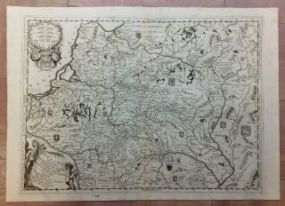
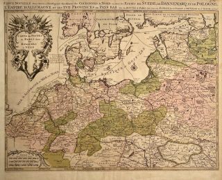
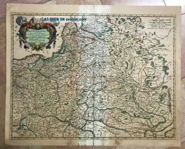
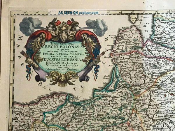
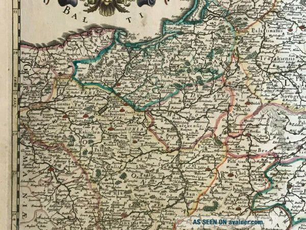
Title of the map:"Tabula nova totius REGNI POLONIAE in quo sunt Ducatus et provinciae Russia, Cujavia, Mazovia, Russia Nigra &c. DUCATUS LITHUANIA, UKRANIA, &c in qua Volhynia et Podolia cum suis Palatinabus ac Confinys"
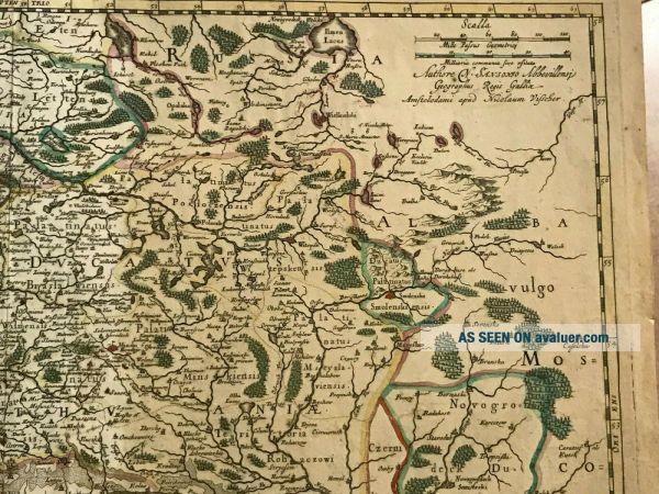
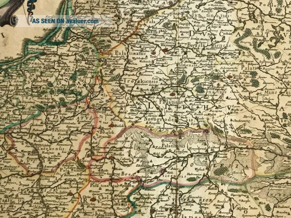
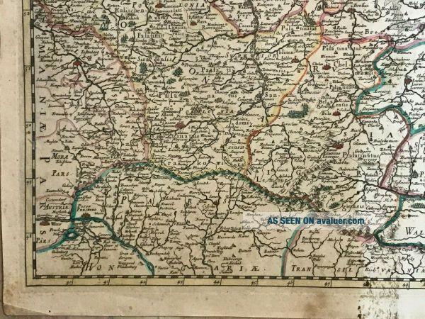
Unusual large antique copper engraved map of Poland, Lithuania, Ukraine, Latvia and Belaruss, by Nicolas VISSCHER II (1649-1702),  XVIIe Century, from a map of Nicolas Sanson d'Abbeville. 

Size with margins : 59 x 47, 5 cm / 23, 2 x... 18, 5 inchesEdition : Amsterdam, 1690, from "Atlas minor sive geographia compendiosa qua orbis terrarum, " XVIIe Century.Condition : a small decoloration in the center, very small repairs on back in the margins, good condition.

If you buy more than one item, you have to pay only one shipping cost.WE DON'T SELL LASER AND COPIES MAPS, ALL WE SELL IS ORIGINAL AND ANTIQUEDue to the age an type of paper, some imperfections are to be expected. Please examine the images provided carefully, and if you have any questions please ask and we will be happy to help you


    Similar items


  • 1690 Nicolas Visscher Antique Map Of Great Britain & Ireland

    1690 Nicolas Visscher Antique Map Of Great Britain & Ireland

  • 056 Antique 1678 Map Of Poland,  Ukraine,  Lithuania Rossi Sanson Large

    056 Antique 1678 Map Of Poland, Ukraine, Lithuania Rossi Sanson Large

  • Lituania Poland 1690 Vincenzo Coronelli Unusual Large Antique Map 17th Century

    Lituania Poland 1690 Vincenzo Coronelli Unusual Large Antique Map 17th Century

  • 1690 Antique Map Poland,  Lithuania,  Belarus,  Germany Sanson Nicolas Rare Map

    1690 Antique Map Poland, Lithuania, Belarus, Germany Sanson Nicolas Rare Map

  • Europe 1646 Nicolas Sanson /mariette Unusual Large Antique Map In Colors

    Europe 1646 Nicolas Sanson /mariette Unusual Large Antique Map In Colors

  • Ireland 1696 Sanson & Jaillot Unusual Large Antique Copper Engraved Map

    Ireland 1696 Sanson & Jaillot Unusual Large Antique Copper Engraved Map

  • Scotland 1693 Sanson/jaillot Unusual Large Antique Copper Engraved Map

    Scotland 1693 Sanson/jaillot Unusual Large Antique Copper Engraved Map

  • Hungary & Balkan Countries 1696 Sanson & Jaillot Unusual Large Antique Map

    Hungary & Balkan Countries 1696 Sanson & Jaillot Unusual Large Antique Map


    • You might also like


    • Hungary & Romania 1579 (1584) Ortelius Unusual Antique Copper Engraved Map

      Hungary & Romania 1579 (1584) Ortelius Unusual Antique Copper Engraved Map

    • Brussels Bruxelles Belfium 1777 De Ferraris & Dupuis Large Antique Map Sheet Xxi

      Brussels Bruxelles Belfium 1777 De Ferraris & Dupuis Large Antique Map Sheet Xxi

    • 1616 Atlas Map Of Iceland.

      1616 Atlas Map Of Iceland.

    • Kazan Russia 1767 Le Clerc/lespinasse Antique Copper Engraved City View

      Kazan Russia 1767 Le Clerc/lespinasse Antique Copper Engraved City View

    • 1899 Stanford,  Folding Map Of Norwich,  Norfolk,  Arthur Collins,  Jarrold & Sons,

      1899 Stanford, Folding Map Of Norwich, Norfolk, Arthur Collins, Jarrold & Sons,

    • 1948 Vintage Linen Colour Map Geological Survey Ten Mile Of Great Britain

      1948 Vintage Linen Colour Map Geological Survey Ten Mile Of Great Britain

    • 1944 Map Flying Bombs Sussex Ww2 Newspaper Military Kent Courier German V1 V2

      1944 Map Flying Bombs Sussex Ww2 Newspaper Military Kent Courier German V1 V2

    • Dated 1638 Vellum Map Of Icklesham Sussex Showing Land Uses Owners Etc

      Dated 1638 Vellum Map Of Icklesham Sussex Showing Land Uses Owners Etc

Avaluer          About Us          Privacy Policy          Contact Us          UP
© 2022, avaluer.net, Inc. or its affiliates