Circa 1690 A Map Of All The Earth J Moxon, King CharlesII & California As Island


Item History & Price

Information:
Reference Number: Avaluer:44968609Cartographer/Publisher: J Moxon
Year: 1690Printing Technique: Copper Plate
Antique: YesOriginal/Reproduction: Antique Original
US State: CaliforniaFormat: Folding Map
Date Range: 1600-1699Type: World map
Era: 1600s
Original Description:
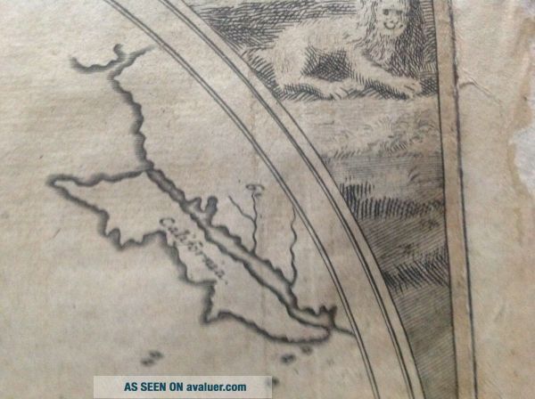
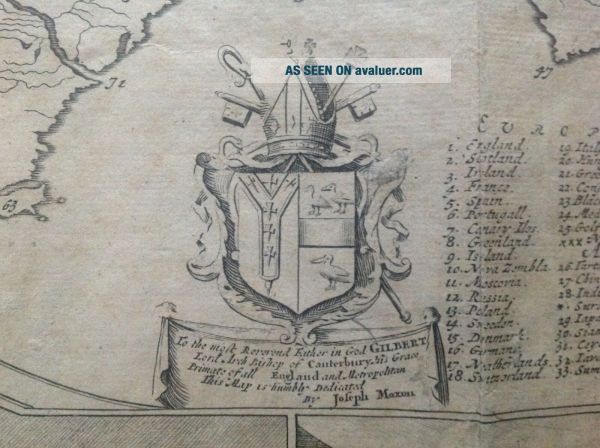
A Map of All the Earth. And how after the Flood it was divided among the Sons of Noah.
By J Moxon
Hydrographer to the King's most Excellent Majesty
Original, but restored and slightly altered (see lower left hand panel), copper plate engraving published in London circa 1690.
Approx image size 12.5 x 18ins


    Similar items


  • Rare Circa 1700 A Map Of North America According To The Newest Observation

    Rare Circa 1700 A Map Of North America According To The Newest Observation

  • Circa 1800 A Map Of Twenty Miles Round The City Of Oxford

    Circa 1800 A Map Of Twenty Miles Round The City Of Oxford

  • A Map Of Narnia & The Surrounding Countries,  1972 Pauline Baynes C.  S.  Lewis Vtg

    A Map Of Narnia & The Surrounding Countries, 1972 Pauline Baynes C. S. Lewis Vtg

  • [1925] Lancashire Printed Books.  A Bibliography Of All The Books Printed In Lanc

    [1925] Lancashire Printed Books. A Bibliography Of All The Books Printed In Lanc

  • 1884 Cram

    1884 Cram ' S Unrivaled Family World Atlas With Maps Of All The States

  • My Dying Bride: A Map Of All Our Failures 2 Lp Vinyl Record Set 2012 Germany

    My Dying Bride: A Map Of All Our Failures 2 Lp Vinyl Record Set 2012 Germany

  • " A " Map Of Georgia The Gulf Coast And Lower Mississippi In 1748

    " A " Map Of Georgia The Gulf Coast And Lower Mississippi In 1748

  • A Map Of Middle Earth Lord Of The Rings Poster Jrr Tolkein First Printing 1970

    A Map Of Middle Earth Lord Of The Rings Poster Jrr Tolkein First Printing 1970


    • You might also like


    • 1860 Mitchell Hand Colored Map Colorado,  Nebraska & Kansas - Civil War Era

      1860 Mitchell Hand Colored Map Colorado, Nebraska & Kansas - Civil War Era

    • 18th Century French Map Of North America

      18th Century French Map Of North America

    • Las Vegas Nevada Vintage 1967 Us Geological Survey Quadrangle Map 4 Panels

      Las Vegas Nevada Vintage 1967 Us Geological Survey Quadrangle Map 4 Panels

    • Rare Antique 1845 Maps United States Exploring Expedition Book Antartica Hawaii

      Rare Antique 1845 Maps United States Exploring Expedition Book Antartica Hawaii

    • Vintage 1926 Map Hollywood From The Best Surveys Of The Time

      Vintage 1926 Map Hollywood From The Best Surveys Of The Time

    • American Continent (western Hemisphere) 1747 Bowen Antique Copper Engraved Map

      American Continent (western Hemisphere) 1747 Bowen Antique Copper Engraved Map

    • Gulf Coast Florida Texas United States 1705 De Fer Unusual Antique Engraved Map

      Gulf Coast Florida Texas United States 1705 De Fer Unusual Antique Engraved Map

    • California As Island United States 1700 De Fer Unusual First Edition Antique Map

      California As Island United States 1700 De Fer Unusual First Edition Antique Map

Avaluer          About Us          Privacy Policy          Contact Us          UP
© 2022, avaluer.net, Inc. or its affiliates