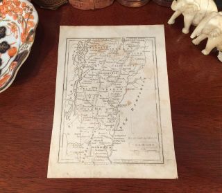
1852 Antique Pre - Civil War VERMONT Hand - Colored Engraved Map


Item History & Price
Fine Adornment of History. Great for Genealogy. Imaginative & Creative Gift.1852 Map of Vermont
Steel-Plate Engraved. Hand-Colored.
Original 1852. 165-yrs-old.
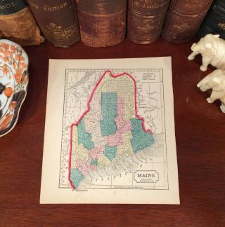
Map is in Very Good/Good condition. No folds, marks, tears, or writings. Mild to Moderate foxing. Not a Reproduction. Original Steel Engraved Map of the 1852 Edition of The First Book of History, Combined with Geography; Containing the History and Geography of The Wes...tern Hemisphere, by the Author of Peter Parley's Tales; Illustrated by Engravings and Colored Maps; Published 1852 by Jenks, Hickling, and Swan: Boston, 1852; a copy of the Title Page of which is Included. Entered According to Act of Congress in the Year 1852 by Jenks, Hickling, and Swan in the Clerk's Office of the District Court of the District of Massachusetts. A Fine Map for the Decorator, Historian, and Collector. Makes an Imaginative and Creative Gift.
Impressive On Any
Home or Office Wall
Dimensions: 4 7/8" x 6 3/4"
Fine Adornment of
Vermont HistoryGreat for History and Family Genealogy, as Map shows Cities, Towns, & Landmarks of 1852, Some of Which No Longer Exist Today.
Excellent Map for the Decorator, Historian, or Collector. Easily Framed. Makes an Imaginative & Creative Gift.
Visit My eBay Store: Atticus Hutchinson AntiquesFree Shipping Special. Maps are mailed the day after purchase & normally arrive within 2-3 days. All Credit & Debit Cards accepted through Paypal. Please email with any questions.Greetings from Historical Savannah, Georgia: Founded 1733.
Press the Store Link Above for More of My Collection.
"Some, to beautify their parlors, chambers, and studies....loveth, getteth, and useth maps, charts, and geographical globes."- John Dee, Advisor to Queen Elizabeth I.
Steel-Plate Engraved. Hand-Colored.
Original 1852. 165-yrs-old.
Map is in Very Good/Good condition. No folds, marks, tears, or writings. Mild to Moderate foxing. Not a Reproduction. Original Steel Engraved Map of the 1852 Edition of The First Book of History, Combined with Geography; Containing the History and Geography of The Wes...tern Hemisphere, by the Author of Peter Parley's Tales; Illustrated by Engravings and Colored Maps; Published 1852 by Jenks, Hickling, and Swan: Boston, 1852; a copy of the Title Page of which is Included. Entered According to Act of Congress in the Year 1852 by Jenks, Hickling, and Swan in the Clerk's Office of the District Court of the District of Massachusetts. A Fine Map for the Decorator, Historian, and Collector. Makes an Imaginative and Creative Gift.
Impressive On Any
Home or Office Wall
Dimensions: 4 7/8" x 6 3/4"
Fine Adornment of
Vermont HistoryGreat for History and Family Genealogy, as Map shows Cities, Towns, & Landmarks of 1852, Some of Which No Longer Exist Today.
Excellent Map for the Decorator, Historian, or Collector. Easily Framed. Makes an Imaginative & Creative Gift.
Visit My eBay Store: Atticus Hutchinson AntiquesFree Shipping Special. Maps are mailed the day after purchase & normally arrive within 2-3 days. All Credit & Debit Cards accepted through Paypal. Please email with any questions.Greetings from Historical Savannah, Georgia: Founded 1733.
Press the Store Link Above for More of My Collection.
"Some, to beautify their parlors, chambers, and studies....loveth, getteth, and useth maps, charts, and geographical globes."- John Dee, Advisor to Queen Elizabeth I.