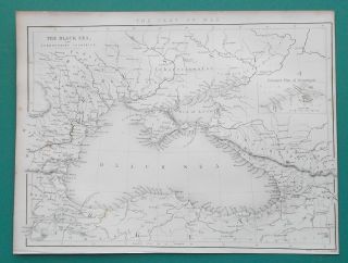
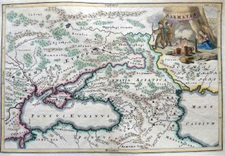
Ukraine Russia Mare Nigrum Moldova - J. B. Homann - Colored Copper Map - 1712


Item History & Price

Information:
Reference Number: Avaluer:46178Type: County Map
Format: Atlas MapDate Range: 1700-1799
Printing Technique: Copper PlateCountry/Region: Moldova, Romania, Russia
Original/Reproduction: Antique OriginalCartographer/Publisher: Johann Baptist Homann
Original Description:
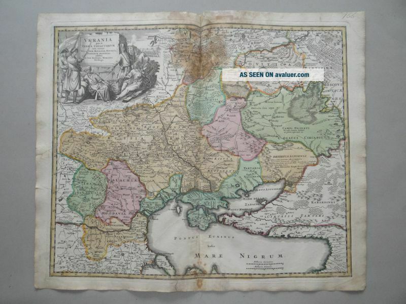
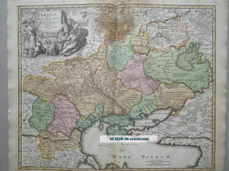
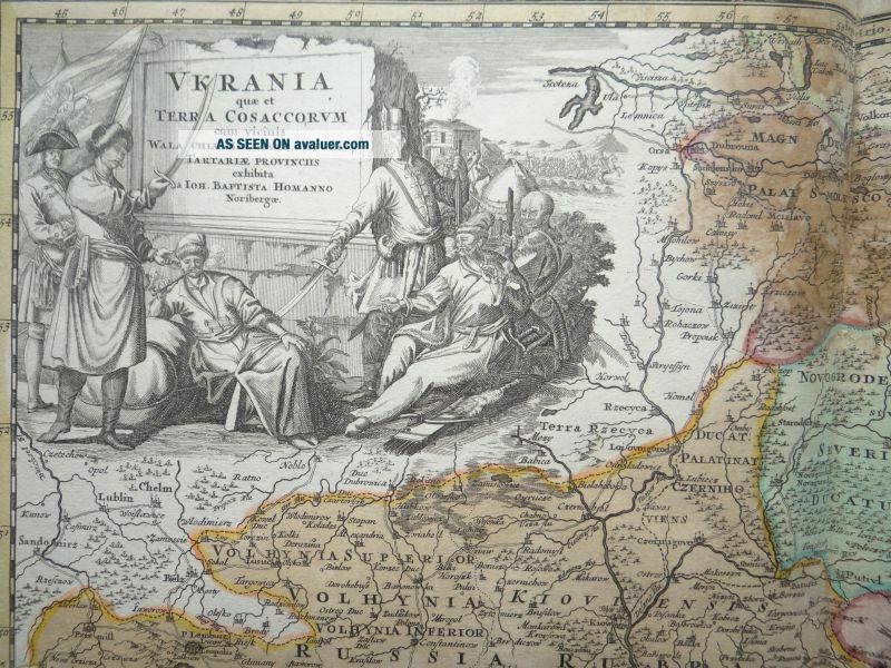
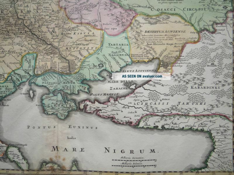
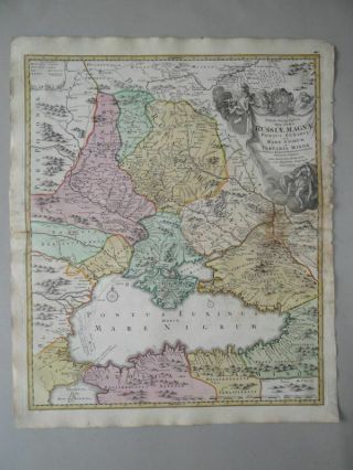
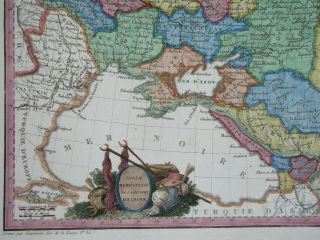
"Ukrania quae et Terra Cosaccorum cum vicinis Walachiae, Moldoviae, Minoris q. Tartariae, Provincus exhibita . . ."colore copper map by Johann Baptist Homann (1664-1724), Nuremberg, (ca. 1712)sheet size (HxL): ca. 20, 36 x 25, 19 inch (53 x 64cm)- browned, slightly spotty, marginal blemishes -More copper maps by J.B. Homann you can find in our current auctions.


    Similar items


  • Rusiae Manga Russia Mare Nigrum Black Sea - Homann - Old Colored Copper Map 1720

    Rusiae Manga Russia Mare Nigrum Black Sea - Homann - Old Colored Copper Map 1720

  • 1812 Map Ukraine Russia Belarus Georgia Moldova Crimea Caucasus

    1812 Map Ukraine Russia Belarus Georgia Moldova Crimea Caucasus

  • 1895 Romania Bulgaria Serbia Montenegro Bukovina Ukraine Russia Moldova Map

    1895 Romania Bulgaria Serbia Montenegro Bukovina Ukraine Russia Moldova Map

  • 4 Patches Customs Moldova Ukraine Russia (2 Pictures)

    4 Patches Customs Moldova Ukraine Russia (2 Pictures)

  • 1840 Antique Map - Black Sea Ukraine Russia Crimea Moldova Turkey Georgia

    1840 Antique Map - Black Sea Ukraine Russia Crimea Moldova Turkey Georgia

  • Sarmatia Romania Ukraine Russia By Cellarius C1703 Antique Engraved Map

    Sarmatia Romania Ukraine Russia By Cellarius C1703 Antique Engraved Map

  • 1855,  Xl - Oldcolored Panoram.  View Of Kerch/kercz[kertch]crimea,  Крым,  Ukraine,  Russia

    1855, Xl - Oldcolored Panoram. View Of Kerch/kercz[kertch]crimea, Крым, Ukraine, Russia

  • 178xl,  Tatary - Crimea,  Ukraine,  Russia,  Zaporizhzhia,  Sevastopol,  Kerch,  Berdyansk,  Yalta

    178xl, Tatary - Crimea, Ukraine, Russia, Zaporizhzhia, Sevastopol, Kerch, Berdyansk, Yalta


    • You might also like


    • Hungary & Romania 1579 (1584) Ortelius Unusual Antique Copper Engraved Map

      Hungary & Romania 1579 (1584) Ortelius Unusual Antique Copper Engraved Map

    • Brussels Bruxelles Belfium 1777 De Ferraris & Dupuis Large Antique Map Sheet Xxi

      Brussels Bruxelles Belfium 1777 De Ferraris & Dupuis Large Antique Map Sheet Xxi

    • 1616 Atlas Map Of Iceland.

      1616 Atlas Map Of Iceland.

    • Kazan Russia 1767 Le Clerc/lespinasse Antique Copper Engraved City View

      Kazan Russia 1767 Le Clerc/lespinasse Antique Copper Engraved City View

    • 1899 Stanford,  Folding Map Of Norwich,  Norfolk,  Arthur Collins,  Jarrold & Sons,

      1899 Stanford, Folding Map Of Norwich, Norfolk, Arthur Collins, Jarrold & Sons,

    • 1948 Vintage Linen Colour Map Geological Survey Ten Mile Of Great Britain

      1948 Vintage Linen Colour Map Geological Survey Ten Mile Of Great Britain

    • 1944 Map Flying Bombs Sussex Ww2 Newspaper Military Kent Courier German V1 V2

      1944 Map Flying Bombs Sussex Ww2 Newspaper Military Kent Courier German V1 V2

    • Dated 1638 Vellum Map Of Icklesham Sussex Showing Land Uses Owners Etc

      Dated 1638 Vellum Map Of Icklesham Sussex Showing Land Uses Owners Etc

Avaluer          About Us          Privacy Policy          Contact Us          UP
© 2022, avaluer.net, Inc. or its affiliates