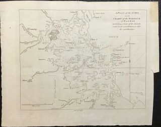
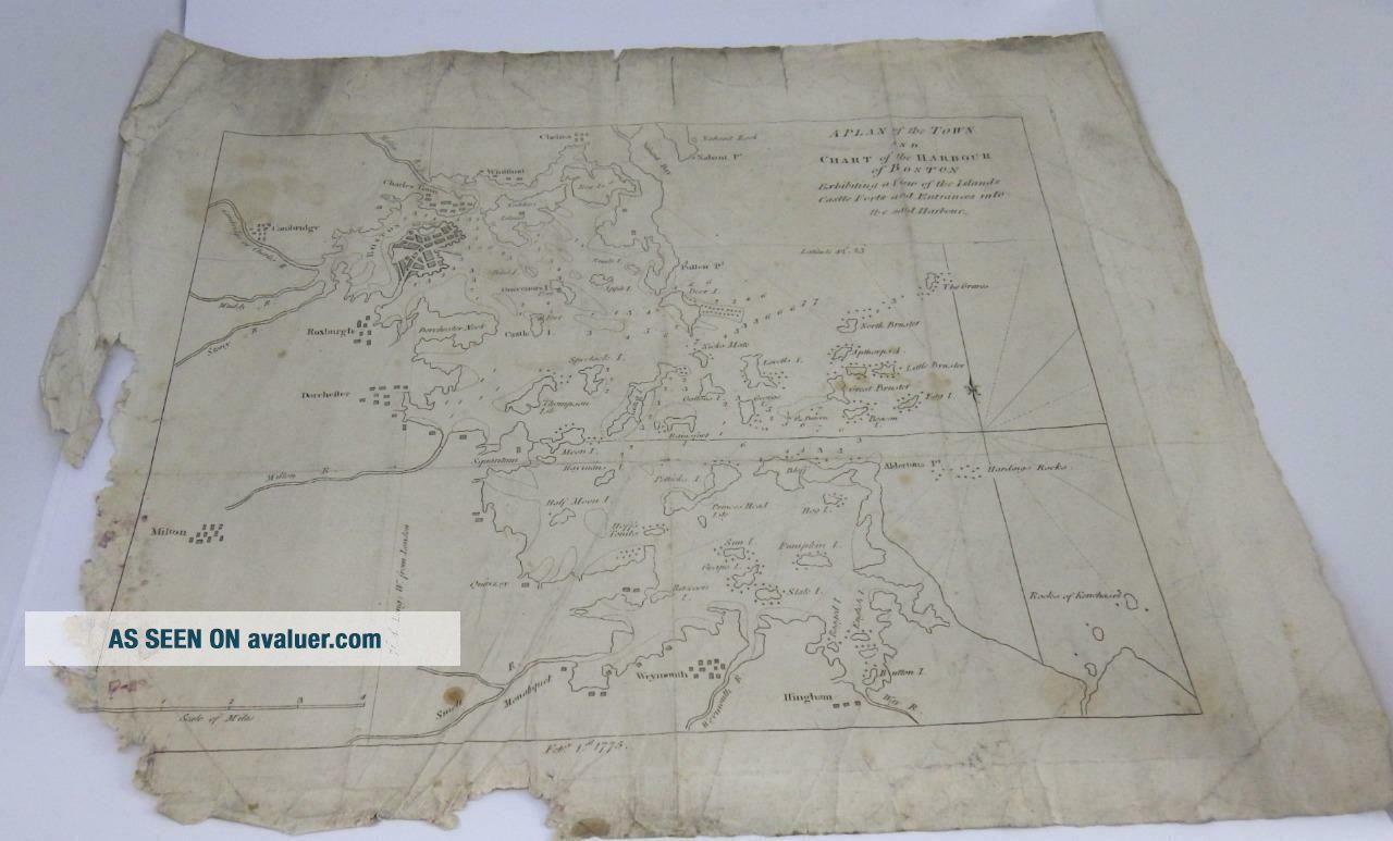
RARE 1775 Antique Map Of A Plan Of The Town & Chart Of The Harbour Of BOSTON


Item History & Price

Information:
Reference Number: Avaluer:47326City: Boston
Original/Reproduction: Antique OriginalCountry/Region: USA
Type: City MapDate Range: 1700-1799
Original Description:


I ship worldwideAmazing - RARE! 18th Century Black & White engraved map of BOSTONDated 1775Entitled 'A Plan of the Town & Chart of the Harbour of BOSTON Islands Castles Forts and Entrances into the said Harbour.'Size - 16" wide x 13.5" high. Condition: fair for age. Dark marks & tears around the edges & to bottom right edge. Wonderful Antique Decor!See photos as they form part of the description. White marks are light reflectionsLISTING MORE ANTIQUE MAPSSales Tax appli...es to items shipped to a Canadian address.

RARE! 1775 Antique Map of A Plan of the Town & Chart of the Harbour of BOSTON


I ship worldwide

Amazing - RARE! 18th Century Black & White engraved map of BOSTON
Dated 1775
Entitled 'A Plan of the Town & Chart of the Harbour of BOSTON Islands Castles Forts and Entrances into the said Harbour.'
Size - 16" wide x 13.5" high. 
Condition: fair for age. Dark marks & tears around the edges & to bottom right edge.  
Wonderful Antique Decor!
See photos as they form part of the description. White marks are light reflections
LISTING MORE ANTIQUE MAPS

Sales Tax applies to items shipped to a Canadian address.
My HST number is 860453653.
Alberta, Manitoba, NWT, Nunavut, BC, Quebec & Yukon are 5%
Saskatchewan is 6%
Ontario & NFL is 13%
PEI is 14%
Nova Scotia & New Brunswick is 15%

View My Other Items For Sale&Add me to your Favorite SellersFollow us on Facebook The Antiques Boutique - BaddeckAlso listing top quality British antique & vintage jewellery, antiquarian books, military items, vintage & unusual items - happy to combine shipping & will ship worldwide.
We no longer ship to Italy due to items 'going missing' in the post.


Payment is by paypal within 3 business days of end of sale.
Sales tax applies when shipping to a Canadian address
 

Your item will be shipped as soon as possible - in most cases wtihin 1 business day. 
Please allow for customs delays & public holidays.
Import taxes are the responsability of the buyer. 
Returns must be made within 7 days of  the sale date.
Buyer pays return shipping and all associated costs eg return customs fees.
No refunds for buyers remorse.

Auction Template Design © In My Cedar Chest
- Unauthorized Duplication Prohibited. Pictures sell!
Auctiva offers Free Image Hosting and Editing.250+ Listing Templates!
Auctiva gets you noticed!

The complete eBay Selling Solution.


    Similar items


  • Rare 1846 Antique Map Of Tennessee S.  A.  Mitchell Nashville Knoxville Stage Routes

    Rare 1846 Antique Map Of Tennessee S. A. Mitchell Nashville Knoxville Stage Routes

  • Very Rare And Desirable 1775 Antique Map Of Boston Revolutionary War

    Very Rare And Desirable 1775 Antique Map Of Boston Revolutionary War

  • Rare Framed Antique Map Of China By Philipp Cluver Published 1697.

    Rare Framed Antique Map Of China By Philipp Cluver Published 1697.

  • Rare C1695 Antique Map Of Shropshire By Robert Morden

    Rare C1695 Antique Map Of Shropshire By Robert Morden

  • Rare Old Antique Map Of London,  England: C1633 1600s: Stuart Period: Reprint

    Rare Old Antique Map Of London, England: C1633 1600s: Stuart Period: Reprint

  • Rare Framed Antique Map Of Berkshire - The Roads From Oxford To Salisbury - 1730

    Rare Framed Antique Map Of Berkshire - The Roads From Oxford To Salisbury - 1730

  • Rare 1772 Antique Map Of America By M.  De Vaugondy Indian Territory 13 Colonies

    Rare 1772 Antique Map Of America By M. De Vaugondy Indian Territory 13 Colonies

  • Rare Old Antique Map Of London,  England: C1633 1600s: Stuart Period: Reprint

    Rare Old Antique Map Of London, England: C1633 1600s: Stuart Period: Reprint


    • You might also like


    • 1860 Mitchell Hand Colored Map Colorado,  Nebraska & Kansas - Civil War Era

      1860 Mitchell Hand Colored Map Colorado, Nebraska & Kansas - Civil War Era

    • 18th Century French Map Of North America

      18th Century French Map Of North America

    • Las Vegas Nevada Vintage 1967 Us Geological Survey Quadrangle Map 4 Panels

      Las Vegas Nevada Vintage 1967 Us Geological Survey Quadrangle Map 4 Panels

    • Rare Antique 1845 Maps United States Exploring Expedition Book Antartica Hawaii

      Rare Antique 1845 Maps United States Exploring Expedition Book Antartica Hawaii

    • Vintage 1926 Map Hollywood From The Best Surveys Of The Time

      Vintage 1926 Map Hollywood From The Best Surveys Of The Time

    • American Continent (western Hemisphere) 1747 Bowen Antique Copper Engraved Map

      American Continent (western Hemisphere) 1747 Bowen Antique Copper Engraved Map

    • Gulf Coast Florida Texas United States 1705 De Fer Unusual Antique Engraved Map

      Gulf Coast Florida Texas United States 1705 De Fer Unusual Antique Engraved Map

    • California As Island United States 1700 De Fer Unusual First Edition Antique Map

      California As Island United States 1700 De Fer Unusual First Edition Antique Map

Avaluer          About Us          Privacy Policy          Contact Us          UP
© 2022, avaluer.net, Inc. or its affiliates