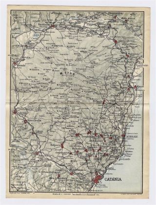
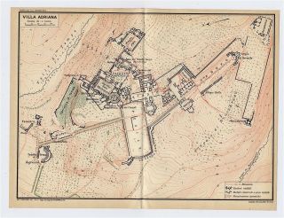
1930 VINTAGE MAP OF VICINITY OF AGRIGENTO / SICILY / ITALY


Item History & Price

Information:
Reference Number: Avaluer:48180026Topic: Maps
Region: ItalyPublication Year: 1930
Subgenre: ItalyType: Map
Maker: BaedekerYear: 1930
Country/Region: ItalyMAP SIZE: 6" x 4" (15 x 10 cm)
Original Description:
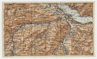
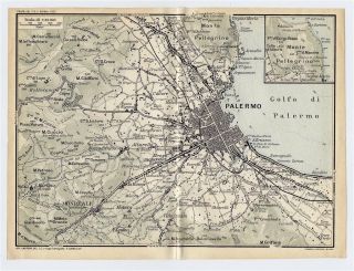
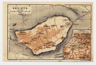
ORIGIN OF THE MAP: "The Blue Guides - Southern Italy", 2nd edition, published in London, UK by Macmillan and Co. Ltd. and in Paris by Librairie Hachette.

DATE OF ISSUE: 1930.

SIZE: 6" x 4" (15 x 10 cm).

Most of maps we sell come from ancient atlases that were damaged and beyond repair. The maps have often a canvas or paper binding tape mounted on back along the centerfold. If you have ANY PROBLEM with the purchase, it is essential you CONTACT US BEFORE LEAVING F...EEDBACK TO GIVE US THE CHANCE TO RESOLVE IT.

SHIPPED FROM CANADA in secure tubes or bubble mailers. PLEASE NOTE, THAT THE SHIPPING FROM QUEBEC TO THE U.S. TAKES 10 DAYS / WORLD 18 DAYS.

We combine shipping costs for multiple items. The HIGHEST VALUE SHIPPING FEE WILL APPLY FIRST and each subsequent item will be shipped FOR FREE.

00100


    Similar items


  • 1930 Vintage Map Of Vicinity Of Catania Sicily Mount Etna Volcano Italy

    1930 Vintage Map Of Vicinity Of Catania Sicily Mount Etna Volcano Italy

  • 1930 Vintage Map Of Vicinity Of Lake Thun Spiez Frutigen Boltigen / Switzerland

    1930 Vintage Map Of Vicinity Of Lake Thun Spiez Frutigen Boltigen / Switzerland

  • 1930 Vintage Map Of Vicinity Of Palermo / Sicily / Italy

    1930 Vintage Map Of Vicinity Of Palermo / Sicily / Italy

  • 1930 Vintage Map Of Orvieto / Umbria / Italy

    1930 Vintage Map Of Orvieto / Umbria / Italy

  • 1930 Vintage Map Of The Isles Of Scilly

    1930 Vintage Map Of The Isles Of Scilly

  • 1937 Antique Europe Map 1930s Vintage Map Of Europe Gallery Wall Art 6176

    1937 Antique Europe Map 1930s Vintage Map Of Europe Gallery Wall Art 6176

  • 1930 Vintage Map Of Hadrian

    1930 Vintage Map Of Hadrian ' S Villa / Tivoli / Lazio / Italy

  • 1937 Antique Europe Map 1930s Vintage Map Of Europe Gallery Wall Art 6794

    1937 Antique Europe Map 1930s Vintage Map Of Europe Gallery Wall Art 6794


    • You might also like


    • Hungary & Romania 1579 (1584) Ortelius Unusual Antique Copper Engraved Map

      Hungary & Romania 1579 (1584) Ortelius Unusual Antique Copper Engraved Map

    • Brussels Bruxelles Belfium 1777 De Ferraris & Dupuis Large Antique Map Sheet Xxi

      Brussels Bruxelles Belfium 1777 De Ferraris & Dupuis Large Antique Map Sheet Xxi

    • 1616 Atlas Map Of Iceland.

      1616 Atlas Map Of Iceland.

    • Kazan Russia 1767 Le Clerc/lespinasse Antique Copper Engraved City View

      Kazan Russia 1767 Le Clerc/lespinasse Antique Copper Engraved City View

    • 1899 Stanford,  Folding Map Of Norwich,  Norfolk,  Arthur Collins,  Jarrold & Sons,

      1899 Stanford, Folding Map Of Norwich, Norfolk, Arthur Collins, Jarrold & Sons,

    • 1948 Vintage Linen Colour Map Geological Survey Ten Mile Of Great Britain

      1948 Vintage Linen Colour Map Geological Survey Ten Mile Of Great Britain

    • 1944 Map Flying Bombs Sussex Ww2 Newspaper Military Kent Courier German V1 V2

      1944 Map Flying Bombs Sussex Ww2 Newspaper Military Kent Courier German V1 V2

    • Dated 1638 Vellum Map Of Icklesham Sussex Showing Land Uses Owners Etc

      Dated 1638 Vellum Map Of Icklesham Sussex Showing Land Uses Owners Etc

Avaluer          About Us          Privacy Policy          Contact Us          UP
© 2022, avaluer.net, Inc. or its affiliates