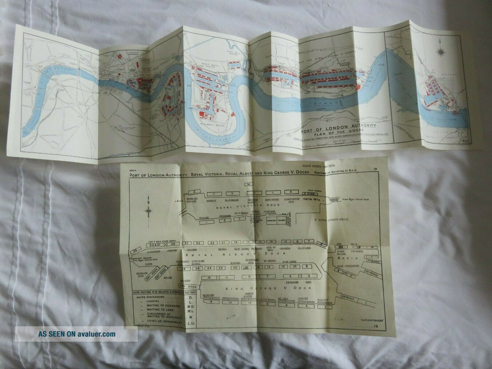
Port Of London Authority Plan Of The Docks River Thames 2 Vintage Maps


Item History & Price

Information:
Reference Number: Avaluer:48194942Type: River Map
Original Description:
2 MAPS
Please see pictures
Any questions please ask
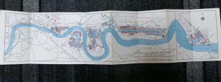
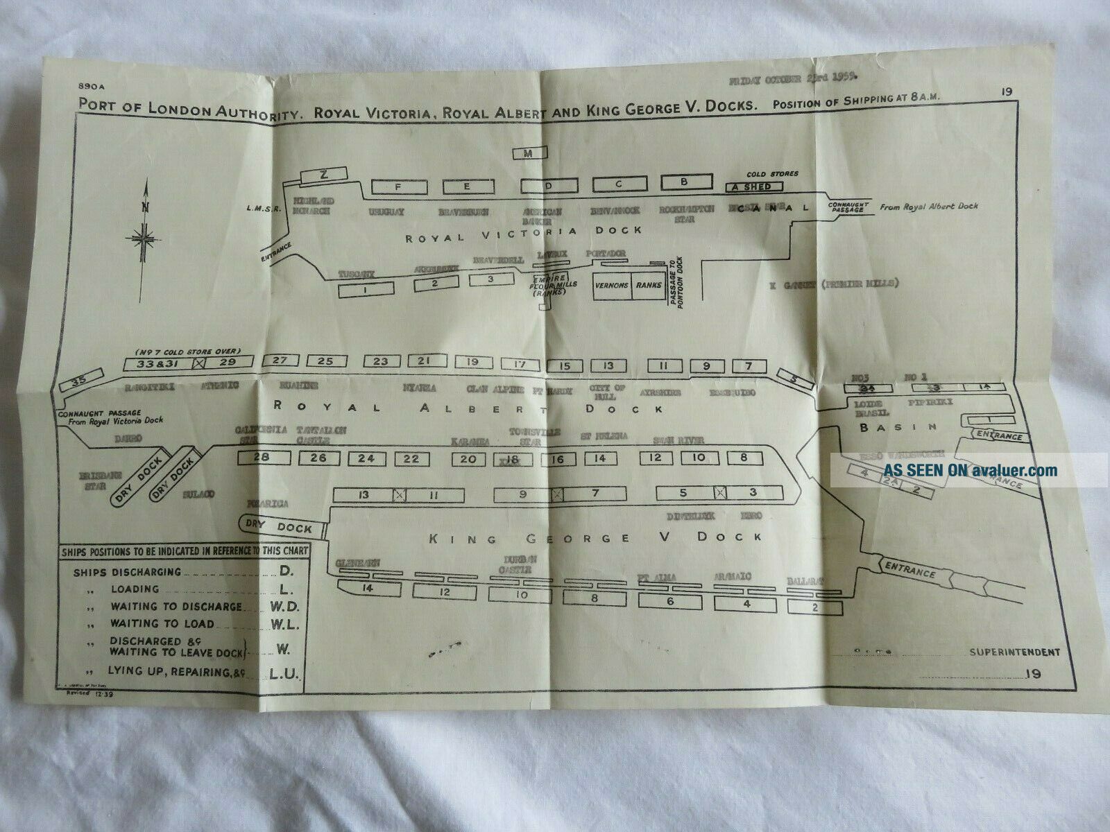
PORT OF LONDON AUTHORITY. ROYAL VICTORIA, ROYAL ALBERT AND KING GEORGE V.DOCKS. POSITION OF SHIPPING AT 8.A.M
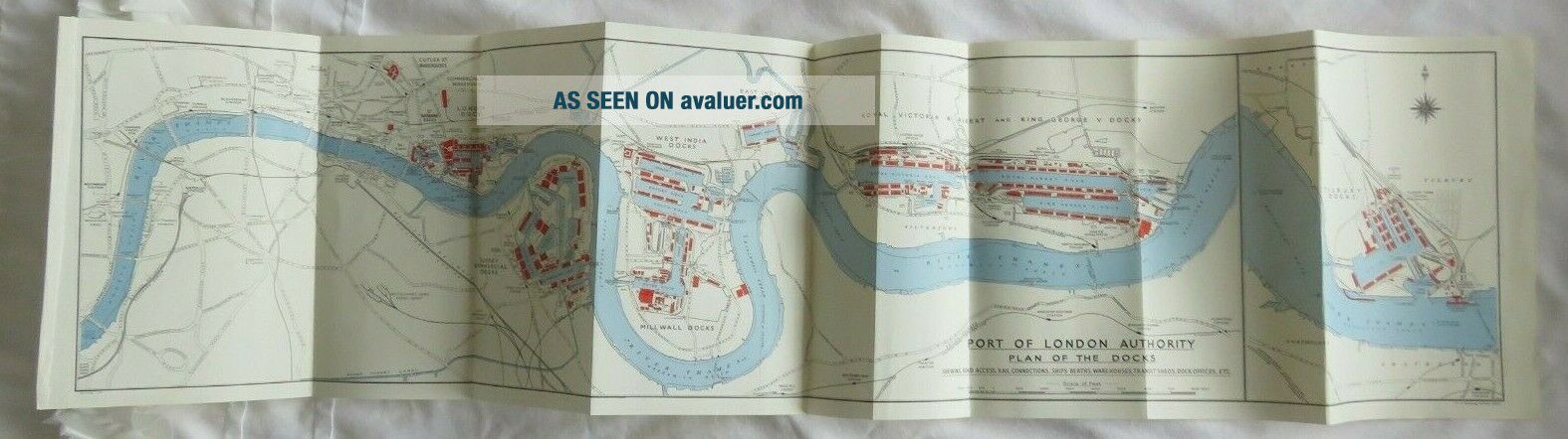
PORT OF LONDON AUTHORITY PLAN OF THE DOCK RIVER THAMES
More items available in my shop


    Similar items


  • Port Of London Authority Plan Of The Docks River Thames 1964

    Port Of London Authority Plan Of The Docks River Thames 1964

  • Romania 1910s Galati Danube Port,  View Of The Docks,  Rare Animated Postcard

    Romania 1910s Galati Danube Port, View Of The Docks, Rare Animated Postcard

  • Ships And Ports Of The Great White Fleet - United Fruit Company - 1940s Booklet.

    Ships And Ports Of The Great White Fleet - United Fruit Company - 1940s Booklet.

  • A Side View Of The Dock And An Admiralty Salvage Ship - Vintage Photo

    A Side View Of The Dock And An Admiralty Salvage Ship - Vintage Photo

  • Bailey Island Maine Me View Of The Dock And Cottages

    Bailey Island Maine Me View Of The Dock And Cottages

  • Greece,  Thessaly:1911 Volos Coloured Postcard Of The Dock.  Editor: S.  Stournaras

    Greece, Thessaly:1911 Volos Coloured Postcard Of The Dock. Editor: S. Stournaras

  • Turkey,  Greece:smyrne Cordelio Postcard Of The Dock.

    Turkey, Greece:smyrne Cordelio Postcard Of The Dock.


    • You might also like


    • Hungary & Romania 1579 (1584) Ortelius Unusual Antique Copper Engraved Map

      Hungary & Romania 1579 (1584) Ortelius Unusual Antique Copper Engraved Map

    • Brussels Bruxelles Belfium 1777 De Ferraris & Dupuis Large Antique Map Sheet Xxi

      Brussels Bruxelles Belfium 1777 De Ferraris & Dupuis Large Antique Map Sheet Xxi

    • 1616 Atlas Map Of Iceland.

      1616 Atlas Map Of Iceland.

    • Kazan Russia 1767 Le Clerc/lespinasse Antique Copper Engraved City View

      Kazan Russia 1767 Le Clerc/lespinasse Antique Copper Engraved City View

    • 1899 Stanford,  Folding Map Of Norwich,  Norfolk,  Arthur Collins,  Jarrold & Sons,

      1899 Stanford, Folding Map Of Norwich, Norfolk, Arthur Collins, Jarrold & Sons,

    • 1948 Vintage Linen Colour Map Geological Survey Ten Mile Of Great Britain

      1948 Vintage Linen Colour Map Geological Survey Ten Mile Of Great Britain

    • 1944 Map Flying Bombs Sussex Ww2 Newspaper Military Kent Courier German V1 V2

      1944 Map Flying Bombs Sussex Ww2 Newspaper Military Kent Courier German V1 V2

    • Dated 1638 Vellum Map Of Icklesham Sussex Showing Land Uses Owners Etc

      Dated 1638 Vellum Map Of Icklesham Sussex Showing Land Uses Owners Etc

Avaluer          About Us          Privacy Policy          Contact Us          UP
© 2022, avaluer.net, Inc. or its affiliates