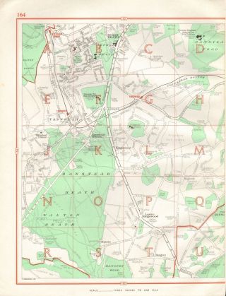
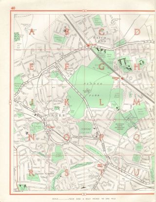
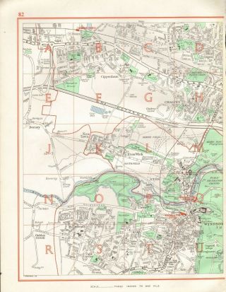
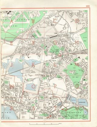
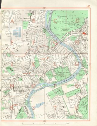
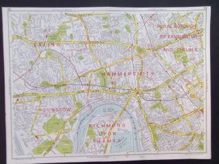
1964 VINTAGE STREET MAP - RICKMANSWORTH, SARRATT, CHORLEYWOOD, CHENIES


Item History & Price

Information:
Reference Number: Avaluer:48196171Format: Street Map
Map Type: City, Roads/ Trails/ TravelRegion: UK
Antique/ Modern: Modern
Original Description:
Detailed larger London & suburbs street map from 1964.  This is from the 'Authentic Map Directory' series, being the first post war issue, London 5th edition. Original colour, suitable for framing, good margins on three sides surrounding image but tight on one side where it was bound in. Scale 3 inches to 1 mile. There is another map verso.  Page Size: Approx 330x 250 mm (13 x 10 ...Inches)Provenance: London Map Directory, Published by Geographia Ltd, 1964. This is the fifth edition of this directory, the first post WW2 editionCondition:Please look at the picture provided. There may be light signs of aging and usage to margins, image very good.  GUARANTEED OVER 50 YEARS OLDThe picture included here is of the actual print for sale, not a stock or library picture.  The vast majority of prints we sell originate from old, disbound books, atlases and magazines. Virtually all antiquarian maps and prints are subject to some normal aging due to use and time which is not obtrusive unless otherwise stated.  We endeavour to describe any faults but please look at the picture. We offer a no questions asked return policy. GUARANTEED ORIGINAL ANTIQUE PRINTThis is an authentic print, published at the date stated above. It is not a modern copy.FREE DOMESTIC POSTAGE


    Similar items


  • 1964 Vintage Street Map - Tadworth,  Banstead Heath,

    1964 Vintage Street Map - Tadworth, Banstead Heath,

  • 1964 Vintage Street Map - Sevenoaks,  Riverhead,  Kippington

    1964 Vintage Street Map - Sevenoaks, Riverhead, Kippington

  • 1964 Vintage Street Map - Hatch End,  Pinner,  Harrow Garden Village

    1964 Vintage Street Map - Hatch End, Pinner, Harrow Garden Village

  • 1964 Vintage Street Map - Cippenham,  Chalvey,  Eton Wick,  Clewer

    1964 Vintage Street Map - Cippenham, Chalvey, Eton Wick, Clewer

  • 1964 Vintage Street Map - Feltham,  Ashford,  Heathrow,  Kempton

    1964 Vintage Street Map - Feltham, Ashford, Heathrow, Kempton

  • 1964 Vintage Street Map - Isleworth,  Patersham,  Richmond,  Twickenham

    1964 Vintage Street Map - Isleworth, Patersham, Richmond, Twickenham

  • London Hammersmith Ealing Holland Park Vintage 1964 Geographia Street Map 9 " X12 "

    London Hammersmith Ealing Holland Park Vintage 1964 Geographia Street Map 9 " X12 "

  • Vintage Street Map Broadstairs Kent 1964/5

    Vintage Street Map Broadstairs Kent 1964/5


    • You might also like


    • Hungary & Romania 1579 (1584) Ortelius Unusual Antique Copper Engraved Map

      Hungary & Romania 1579 (1584) Ortelius Unusual Antique Copper Engraved Map

    • Brussels Bruxelles Belfium 1777 De Ferraris & Dupuis Large Antique Map Sheet Xxi

      Brussels Bruxelles Belfium 1777 De Ferraris & Dupuis Large Antique Map Sheet Xxi

    • 1616 Atlas Map Of Iceland.

      1616 Atlas Map Of Iceland.

    • Kazan Russia 1767 Le Clerc/lespinasse Antique Copper Engraved City View

      Kazan Russia 1767 Le Clerc/lespinasse Antique Copper Engraved City View

    • 1899 Stanford,  Folding Map Of Norwich,  Norfolk,  Arthur Collins,  Jarrold & Sons,

      1899 Stanford, Folding Map Of Norwich, Norfolk, Arthur Collins, Jarrold & Sons,

    • 1948 Vintage Linen Colour Map Geological Survey Ten Mile Of Great Britain

      1948 Vintage Linen Colour Map Geological Survey Ten Mile Of Great Britain

    • 1944 Map Flying Bombs Sussex Ww2 Newspaper Military Kent Courier German V1 V2

      1944 Map Flying Bombs Sussex Ww2 Newspaper Military Kent Courier German V1 V2

    • Dated 1638 Vellum Map Of Icklesham Sussex Showing Land Uses Owners Etc

      Dated 1638 Vellum Map Of Icklesham Sussex Showing Land Uses Owners Etc

Avaluer          About Us          Privacy Policy          Contact Us          UP
© 2022, avaluer.net, Inc. or its affiliates