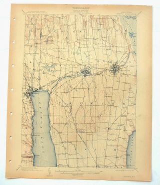
Mineral Point Wisconsin Antique USGS Topographic Map 1902 Platteville Topo
Item History & Price
MINERAL POINT WISCONSIN USGS TOPO MAP 1902 Vintage Cartographics Wisconsin Maps ∙ Antique Prints ∙ Bargain Bin ∙ Browse Nearby Sheets 1902
Mineral Point
Wisconsin, Illinois
USGS TOPOGRAPHIC MAP
1917 print in fair condition
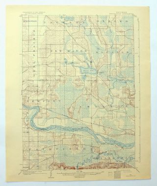
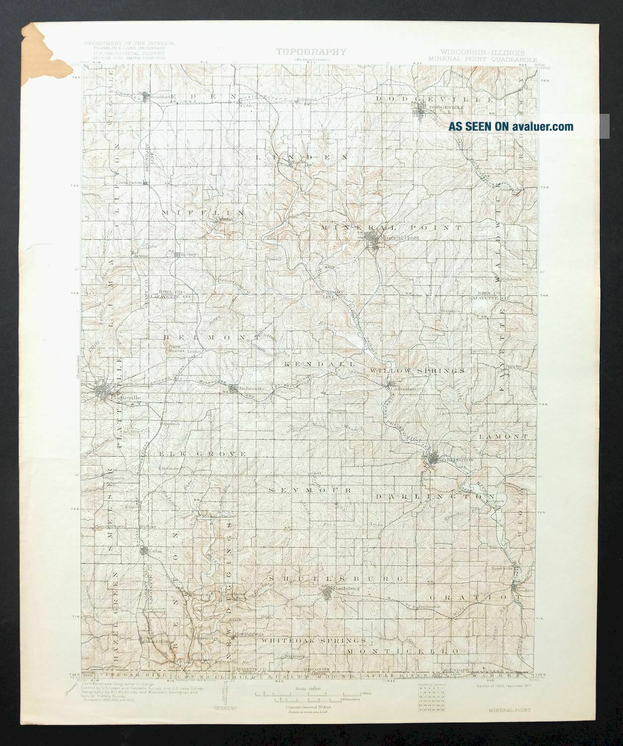
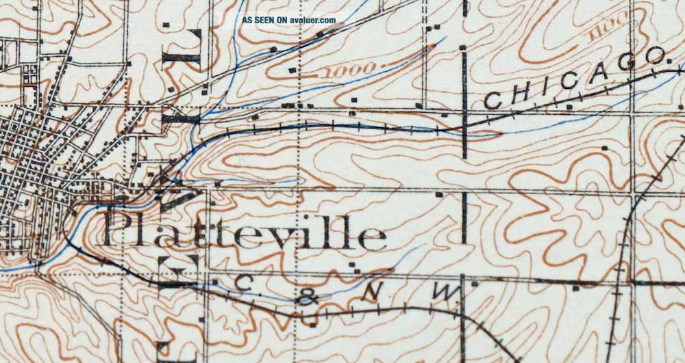
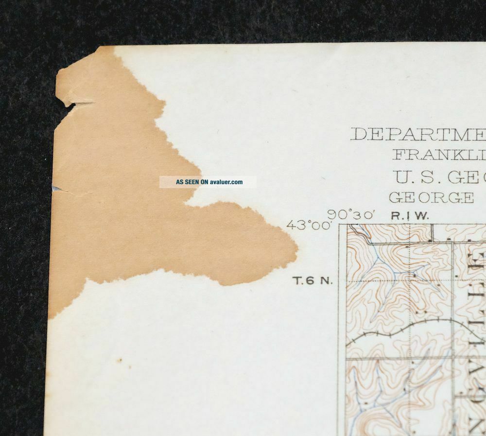
For sale is the 1902 edition of the Mineral Point 30-minute map. This map would be great for historical reference o...r research, genealogy studies, adding to a collection, treasure hunting, a nice conversation piece, a gift for a history or map enthusiast, or for anyone interested in this area. This sheet includes the first survey produced by the United States Geological Survey for the Mineral Point 30-minute quadrangle. The map is an original 1917 USGS print that is 102-year-old years old and in fair condition. The Mineral Point 30-minute map shows roads, paths, towns, railroads, rivers, creeks, elevation contour lines, public land survey lines, county, state, and other administrative boundaries, and many structures (houses, churches, schools, barns, etc.) as they existed at the time of the survey in 1900 through 1904. The Mineral Point map was field surveyed before aerial photography methods were widely used in map data gathering. It was drawn by cartographers based on plane table field survey information as well as information gathered from local residents in the area. It displays the remarkable abilities of early government map makers, who placed a strong emphasis on creating complete, accurate, and cartographically appealing maps. Maps from the USGS 30-minute series have been out of print for many years. They have never been common and original prints are increasingly difficult to find. For areas where the 30-minute map was produced, it is usually the first large-scale survey done by the USGS for that area. These are a valuable historical record, as they contain many placenames and features that have been dropped from more recent series' and editions. MAP DETAILS Title Mineral Point State Wisconsin, Illinois Series 30-minute Surveyed 1900 through 1904 Field Survey Geographer Jno. H. Renshawe Engraved 1902 Edition 1902 Printed 1917, thick paper stock Woodland Tint No Scale 1:125000 Contour Interval 20 Foot Sheet Dimensions 16 x 20 inches (approximate) Map Dimensions 12 7/8 x 17 1/2 inches Coverage Area 25 x 35 miles Notes collar condition does not affect framing potential or the valuable historical information contained within the map area SHEET CONDITION For maps of this vintage, effort is made to note all visible flaws, no matter how minor. Overall Condition FAIR Sheet Notes very lightly handled, never folded, lightly age-toned sheet, smooth and flat Map Area flawless map area Collar Area no markings, considerable dark blemish in upper left collar corner, edge tears carefully stabilized with clear archival tape on backside of sheet MAP COVERAGE Quadrangle extent overlaid on current basemap. Browse Nearby
Sheets PLACENAMES Depending on map series and survey date, all of the features listed below may not be shown on this map. This list contains features that currently exist or historically existed within the area covered by this map. The list can be used as a reference to determine if this map covers your area of interest. Placenames are listed alphabetically next to each feature type. Cities and Towns (current) Apple River, Belmont, Benton, Calamine, Cobb, Cuba City, Darlington, Dodgeville, Gratiot, Hazel Green, Linden, Livingston, Mineral Point, Montfort, New Diggings, Platteville, Rewey, Ridgeway, Shullsburg, Waldwick, and Warren Counties Covered Grant, Iowa, Jo Daviess, and Lafayette Rivers and Streams Ames Branch, Apple River, Badger Hollow Creek, Baker Creek, Bear Branch, Blacks Creek, Blockhouse Creek, Blotz Branch, Blue River, Bonner Branch, Brewery Creek, Bull Branch, Canon Creek, Canyon Park Creek, Cave Hollow Creek, Clear Creek, Conley Lewis Creek, Coon Branch, Copper Creek, Cottage Inn Branch, Crow Branch, Cutler Creek, Diggins Creek, Dodge Branch, East Fork Galena River, Ellis Branch, Flint Creek, French Creek, Fritsch Creek, Furnace Creek, Galena River, Gribble Branch, Harker Creek, Jones Branch, Kelsey Branch, Kentucky Creek, Lee Creek, Ley Creek, Little Platte River, Livingston Branch, Lovett Creek, Lynch Branch, Madden Branch, Martin Creek, McAdam Branch, Mineral Point Branch, Mounds Branch, Mud Branch, North Fork Ames Branch, Otter Creek, Pats Creek, Pecatonica River, Pedler Creek, Pengelly Creek, Platte River, Rock Branch, Scrabble Branch, Shullsburg Branch, Silver Spring Creek, Simmons Branch, Sinsinawa River, Smith Conley Creek, Snowden Branch, South Fork Ames Branch, Spring Branch, Steiner Branch, Sudah Branch, Thunder Branch, Trout Brook, Vinegar Branch, West Fork Apple River, Williams-rewey Branch, Wolf Creek, Wood Branch, and Yellowstone River Water Bodies Beardsley Lake and Lake Joy 2 IN WISCONSIN Populated Places: Arthur, Avon, Calamine, Belmont, Benton, Bigpatch, Cobb, Cuba City, Darlington, Dodgeville, Dunbarton, Edmund, Elk Grove, Elmo, Etna, Fayette, Georgetown, Gratiot, Hazel Green, Ipswich, Jenkinsville, Jonesdale, Lead Mine, Leslie, Linden, Livingston, Meekers Grove, Mifflin, Mineral Point, Montfort, New Diggings, Platteville, Red Rock, Rewey, Riverside, Saint Rose, Shullsburg, Slateford, Strawbridge, Truman, Waldwick, and White Oak. Post Offices: Platteville Post Office. Locations: Central School, Seymour Corners, and Walnut Grove School. Administrative Boundaries: Town of Belmont, Village of Belmont, Town of Benton, Village of Benton, Town of Clifton, Village of Cobb, Cuba City, City of Darlington, Town of Darlington, City of Dodgeville, Town of Eden, Town of Elk Grove, Town of Fayette, Town of Gratiot, Village of Gratiot, Town of Hazel Green, Village of Hazel Green, Town of Kendall, Town of Lamont, Town of Lima, Town of Linden, Village of Linden, Village of Livingston, Town of Mifflin, City of Mineral Point, Town of Mineral Point, Village of Montfort, Town of Monticello, Town of New Diggings, City of Platteville, Town of Platteville, Village of Rewey, Town of Seymour, City of Shullsburg, Town of Shullsburg, Town of Smelser, Town of Waldwick, Town of White Oak Springs, Town of Willow Springs, and Town of Wingville. Mountains, Peaks, and Summits: Belmont Mound, Little Mound, Platte Mounds, and White Hill. Valleys and Canyons: Foreman Hollow. Parks: City Hall Park, First Capitol State Park, Legion Park, Smith Park, and Soldiers Memorial Park. Drainages: Ames Branch, Baker Creek, Bear Branch, Blacks Creek, Blotz Branch, Bonner Branch, Brewery Creek, Bull Branch, Cave Hollow Creek, Coon Branch, Copper Creek, Cottage Inn Branch, Diggins Creek, Ellis Branch, Fritsch Creek, Furnace Creek, Gravel Run Creek, Gribble Branch, Jones Branch, Kelsey Branch, Ley Creek, Livingston Branch, Lovett Creek, Lynch Branch, Madden Branch, Martin Creek, Mineral Point Branch, Mounds Branch, North Fork Ames Branch, Otter Creek, Pats Creek, Pedler Creek, Rock Branch, Scrabble Branch, Shullsburg Branch, Simmons Branch, South Fork Ames Branch, Spring Branch, Sudan Branch, Thunder Branch, Trout Brook, Vinegar Branch, Whiteside Branch, Williams-Rewey Branch, Wolf Creek, and Wood Branch. Mines: Acme Mine, Blackstone Mine, Burkett Mine, Calumet and Hecla Mine, Homestead Mine, Leo V Mine, Liberty Mine, Mifflin Mine, Mulcahy Mine, New Dall Mine, and Rasque Mine. Churches: Bethel Church, Bethlehem Church, Bryn Zion Church, Carmel Church, Evangelical Lutheran Church of Peace, First Congregational United Church of Christ, First English Lutheran Church, First United Methodist Church, Free Methodist Church, Lead Mine Church, Peniel Church, Pleasant View Church, Plymouth Congregational Church, Roseville Church, Saint Joseph Church, Saint Marys Church, Saint Marys Roman Catholic Church, Saint Pauls Evangelical Lutheran Church, Simpson Chapel, Trinity Episcopal Church, and Willow Springs Church. Hospitals: Memorial Hospital of Iowa County. Dams: Hutchinson Dam, John Gobracht G-6513 Dam, Klein G1349.1 Dam, Ludden Lake 2WP1659 Dam, McNett E6379 Dam, Metz Number 1 G9922 Dam, Metz Number 2 G9922 Dam, Robert Coyier G9994 Dam, and Wright-Palzkill 3SD78808 Dam. Buildings: Jamison Museum, Mining Museum, and Platteville City Hall. Reservoirs and Tanks: .43 Reservoir, 0.3 Reservoir, 0.37 Reservoir, 0.49 Reservoir, 0.6 Reservoir, 1 Reservoir, Beardsley Lake, Lake Joy 2, and Ludden Lake. Towers: WDMP-AM (Dodgeville), WDMP-FM (Dodgeville), WJTY-FM (Lancaster), WSUP-FM (Platteville), and WTOQ-AM (Platteville). Airports: Darlington Aviation Inc Airport, Dodgeville Municipal Airport, Grant County Airport, Iowa County Airport, Memorial Hospital Heliport, Shullsburg Airport, and Tuschen Airport. Schools: Bachford School, Barreltown School, Bethel Grove School, Bethel School, Blockhouse School, Bloomfield School, Broad View School, Burr Oak School, Belmont Elementary School, Benton Elementary School, Benton High School, Bigpatch School, Black Bear School, Brannon School, Carpenter School, Carr School, Center School, Cottage Inn School, Diamond Grove School, Dodgeville Elementary School, Dodgeville High School, Dublin School, Dunbarton School, Elmo School, Glenville School, Grant School, Greenwood School, Hamestreet School, Hazel Dell School, Hazel Valley School, Heil School, Holland School, Hollyhead School, Holy Rosary Grade School, Hopewell School, Hovey School, Ipswich School, Jackson School, Jamesville School, Jericho School, Johnny Cake School, Keo Springs School, Lead Mine School, Leslie School, Levitt School, Lincoln School, Lone School, Lost Grove School, Martinville School, Meylor School, Milltown School, Mineral Point Elementary School, Model School, Mound Valley School, Mount Vernon School, Mullen School, New Providence School, North Hollow School, North Survey School, O'Brien School, O'Toole School, Oak Grove School, Oak Park School, Oaklawn School, Otter Creek School, Paper School, Parkinson School, Peniel School, Pine Grove School, Platteville High School, Platteville Middle School, Pleasant View School, Plum Grove School, Race Track School, Red Rock School, Robbins School, Rock School, Rowe School, Saint Joseph Grade School, Saint Mary Parish School, Saint Peters School, Salty Hollow School, Seven Oaks School, Seymour Central School, Silverthorne School, South Survey School, Strawberry School, Sullivan School, Summit School, Sunny Dale School, Sunny Slope School, Sunnyside School, Sweet Clover School, Truman School, University of Wisconsin - Platteville, Vickers School, Wardsville School, Waterloo School, West Mound School, West School, White Thorne School, Whitson View School, Willow Branch School, Willow Grove School, Willow Park School, Willow Springs School, Wisconsin Institute of Technology, Wood Branch School, Woodchuck School, and Youle School. IN ILLINOIS Populated Places: Apple River. Mountains, Peaks, and Summits: Charles Mound. Mines: Northwestern Mine and Unity Mine. Schools: Veda Grand School. BACKSIDE LEGEND A map summary is printed on the back side of the Mineral Point sheet similar to the one shown in the picture. It outlines the history, purpose, and status of the USGS mapping program at the time of the printing in 1917. It also provides instructions on how to read contour lines and a description of how they are used to depict the terrain. At the bottom of the page is a legend showing all of the symbols used to represent the cultural, relief, and water features found on the map. SHIPPING AND RETURNS This map sheet will be carefully rolled in a sturdy tube and shipped via the US Postal Service. Shipping and handling costs are included in the purchase price.
If you find that the sheet you receive is not as described in the listing, you may ship it back to us for a refund of the purchase price. 15~4015 15~4016 15~4017 15~4018 15~4019 15~4020 15~4218 15~4219 15~4220 15~4221 15~4222 15~4223 15~4224 15~4225 15~4426 15~4427 15~4428 15~4429 15~4628 15~4629 15~4630 15~4631 15~4829 15~4830 15~4831 15~4832 15~4833 15~4834 15~5034 15~5035 15~5036 15~5037 15~5038 15~5039 30~1096 30~1097 30~1099 30~1200 30~1201 30~1202 30~1203 30~1304 30~1305 30~1306 30~1412 30~1413 30~1414 75~15712 75~15713 75~15714 75~15715 75~15716 75~15897 75~16119 75~16120 75~16121 75~16122 75~16123 75~16124 75~16125 75~16126 75~16535 75~16536 75~16537 75~16538 75~16539 75~16540 75~16541 75~16542 75~16691 75~16692 75~16922 75~16923 75~16924 75~16925 75~16926 75~16927 75~16928 75~16929 75~16930 75~17084 75~17323 75~17324 75~17325 75~17326 75~17327 75~17486 75~17487 75~17488 75~17713 75~17714 75~17715 75~17716 75~17717 75~17871
Mineral Point
Wisconsin, Illinois
USGS TOPOGRAPHIC MAP
1917 print in fair condition
For sale is the 1902 edition of the Mineral Point 30-minute map. This map would be great for historical reference o...r research, genealogy studies, adding to a collection, treasure hunting, a nice conversation piece, a gift for a history or map enthusiast, or for anyone interested in this area. This sheet includes the first survey produced by the United States Geological Survey for the Mineral Point 30-minute quadrangle. The map is an original 1917 USGS print that is 102-year-old years old and in fair condition. The Mineral Point 30-minute map shows roads, paths, towns, railroads, rivers, creeks, elevation contour lines, public land survey lines, county, state, and other administrative boundaries, and many structures (houses, churches, schools, barns, etc.) as they existed at the time of the survey in 1900 through 1904. The Mineral Point map was field surveyed before aerial photography methods were widely used in map data gathering. It was drawn by cartographers based on plane table field survey information as well as information gathered from local residents in the area. It displays the remarkable abilities of early government map makers, who placed a strong emphasis on creating complete, accurate, and cartographically appealing maps. Maps from the USGS 30-minute series have been out of print for many years. They have never been common and original prints are increasingly difficult to find. For areas where the 30-minute map was produced, it is usually the first large-scale survey done by the USGS for that area. These are a valuable historical record, as they contain many placenames and features that have been dropped from more recent series' and editions. MAP DETAILS Title Mineral Point State Wisconsin, Illinois Series 30-minute Surveyed 1900 through 1904 Field Survey Geographer Jno. H. Renshawe Engraved 1902 Edition 1902 Printed 1917, thick paper stock Woodland Tint No Scale 1:125000 Contour Interval 20 Foot Sheet Dimensions 16 x 20 inches (approximate) Map Dimensions 12 7/8 x 17 1/2 inches Coverage Area 25 x 35 miles Notes collar condition does not affect framing potential or the valuable historical information contained within the map area SHEET CONDITION For maps of this vintage, effort is made to note all visible flaws, no matter how minor. Overall Condition FAIR Sheet Notes very lightly handled, never folded, lightly age-toned sheet, smooth and flat Map Area flawless map area Collar Area no markings, considerable dark blemish in upper left collar corner, edge tears carefully stabilized with clear archival tape on backside of sheet MAP COVERAGE Quadrangle extent overlaid on current basemap. Browse Nearby
Sheets PLACENAMES Depending on map series and survey date, all of the features listed below may not be shown on this map. This list contains features that currently exist or historically existed within the area covered by this map. The list can be used as a reference to determine if this map covers your area of interest. Placenames are listed alphabetically next to each feature type. Cities and Towns (current) Apple River, Belmont, Benton, Calamine, Cobb, Cuba City, Darlington, Dodgeville, Gratiot, Hazel Green, Linden, Livingston, Mineral Point, Montfort, New Diggings, Platteville, Rewey, Ridgeway, Shullsburg, Waldwick, and Warren Counties Covered Grant, Iowa, Jo Daviess, and Lafayette Rivers and Streams Ames Branch, Apple River, Badger Hollow Creek, Baker Creek, Bear Branch, Blacks Creek, Blockhouse Creek, Blotz Branch, Blue River, Bonner Branch, Brewery Creek, Bull Branch, Canon Creek, Canyon Park Creek, Cave Hollow Creek, Clear Creek, Conley Lewis Creek, Coon Branch, Copper Creek, Cottage Inn Branch, Crow Branch, Cutler Creek, Diggins Creek, Dodge Branch, East Fork Galena River, Ellis Branch, Flint Creek, French Creek, Fritsch Creek, Furnace Creek, Galena River, Gribble Branch, Harker Creek, Jones Branch, Kelsey Branch, Kentucky Creek, Lee Creek, Ley Creek, Little Platte River, Livingston Branch, Lovett Creek, Lynch Branch, Madden Branch, Martin Creek, McAdam Branch, Mineral Point Branch, Mounds Branch, Mud Branch, North Fork Ames Branch, Otter Creek, Pats Creek, Pecatonica River, Pedler Creek, Pengelly Creek, Platte River, Rock Branch, Scrabble Branch, Shullsburg Branch, Silver Spring Creek, Simmons Branch, Sinsinawa River, Smith Conley Creek, Snowden Branch, South Fork Ames Branch, Spring Branch, Steiner Branch, Sudah Branch, Thunder Branch, Trout Brook, Vinegar Branch, West Fork Apple River, Williams-rewey Branch, Wolf Creek, Wood Branch, and Yellowstone River Water Bodies Beardsley Lake and Lake Joy 2 IN WISCONSIN Populated Places: Arthur, Avon, Calamine, Belmont, Benton, Bigpatch, Cobb, Cuba City, Darlington, Dodgeville, Dunbarton, Edmund, Elk Grove, Elmo, Etna, Fayette, Georgetown, Gratiot, Hazel Green, Ipswich, Jenkinsville, Jonesdale, Lead Mine, Leslie, Linden, Livingston, Meekers Grove, Mifflin, Mineral Point, Montfort, New Diggings, Platteville, Red Rock, Rewey, Riverside, Saint Rose, Shullsburg, Slateford, Strawbridge, Truman, Waldwick, and White Oak. Post Offices: Platteville Post Office. Locations: Central School, Seymour Corners, and Walnut Grove School. Administrative Boundaries: Town of Belmont, Village of Belmont, Town of Benton, Village of Benton, Town of Clifton, Village of Cobb, Cuba City, City of Darlington, Town of Darlington, City of Dodgeville, Town of Eden, Town of Elk Grove, Town of Fayette, Town of Gratiot, Village of Gratiot, Town of Hazel Green, Village of Hazel Green, Town of Kendall, Town of Lamont, Town of Lima, Town of Linden, Village of Linden, Village of Livingston, Town of Mifflin, City of Mineral Point, Town of Mineral Point, Village of Montfort, Town of Monticello, Town of New Diggings, City of Platteville, Town of Platteville, Village of Rewey, Town of Seymour, City of Shullsburg, Town of Shullsburg, Town of Smelser, Town of Waldwick, Town of White Oak Springs, Town of Willow Springs, and Town of Wingville. Mountains, Peaks, and Summits: Belmont Mound, Little Mound, Platte Mounds, and White Hill. Valleys and Canyons: Foreman Hollow. Parks: City Hall Park, First Capitol State Park, Legion Park, Smith Park, and Soldiers Memorial Park. Drainages: Ames Branch, Baker Creek, Bear Branch, Blacks Creek, Blotz Branch, Bonner Branch, Brewery Creek, Bull Branch, Cave Hollow Creek, Coon Branch, Copper Creek, Cottage Inn Branch, Diggins Creek, Ellis Branch, Fritsch Creek, Furnace Creek, Gravel Run Creek, Gribble Branch, Jones Branch, Kelsey Branch, Ley Creek, Livingston Branch, Lovett Creek, Lynch Branch, Madden Branch, Martin Creek, Mineral Point Branch, Mounds Branch, North Fork Ames Branch, Otter Creek, Pats Creek, Pedler Creek, Rock Branch, Scrabble Branch, Shullsburg Branch, Simmons Branch, South Fork Ames Branch, Spring Branch, Sudan Branch, Thunder Branch, Trout Brook, Vinegar Branch, Whiteside Branch, Williams-Rewey Branch, Wolf Creek, and Wood Branch. Mines: Acme Mine, Blackstone Mine, Burkett Mine, Calumet and Hecla Mine, Homestead Mine, Leo V Mine, Liberty Mine, Mifflin Mine, Mulcahy Mine, New Dall Mine, and Rasque Mine. Churches: Bethel Church, Bethlehem Church, Bryn Zion Church, Carmel Church, Evangelical Lutheran Church of Peace, First Congregational United Church of Christ, First English Lutheran Church, First United Methodist Church, Free Methodist Church, Lead Mine Church, Peniel Church, Pleasant View Church, Plymouth Congregational Church, Roseville Church, Saint Joseph Church, Saint Marys Church, Saint Marys Roman Catholic Church, Saint Pauls Evangelical Lutheran Church, Simpson Chapel, Trinity Episcopal Church, and Willow Springs Church. Hospitals: Memorial Hospital of Iowa County. Dams: Hutchinson Dam, John Gobracht G-6513 Dam, Klein G1349.1 Dam, Ludden Lake 2WP1659 Dam, McNett E6379 Dam, Metz Number 1 G9922 Dam, Metz Number 2 G9922 Dam, Robert Coyier G9994 Dam, and Wright-Palzkill 3SD78808 Dam. Buildings: Jamison Museum, Mining Museum, and Platteville City Hall. Reservoirs and Tanks: .43 Reservoir, 0.3 Reservoir, 0.37 Reservoir, 0.49 Reservoir, 0.6 Reservoir, 1 Reservoir, Beardsley Lake, Lake Joy 2, and Ludden Lake. Towers: WDMP-AM (Dodgeville), WDMP-FM (Dodgeville), WJTY-FM (Lancaster), WSUP-FM (Platteville), and WTOQ-AM (Platteville). Airports: Darlington Aviation Inc Airport, Dodgeville Municipal Airport, Grant County Airport, Iowa County Airport, Memorial Hospital Heliport, Shullsburg Airport, and Tuschen Airport. Schools: Bachford School, Barreltown School, Bethel Grove School, Bethel School, Blockhouse School, Bloomfield School, Broad View School, Burr Oak School, Belmont Elementary School, Benton Elementary School, Benton High School, Bigpatch School, Black Bear School, Brannon School, Carpenter School, Carr School, Center School, Cottage Inn School, Diamond Grove School, Dodgeville Elementary School, Dodgeville High School, Dublin School, Dunbarton School, Elmo School, Glenville School, Grant School, Greenwood School, Hamestreet School, Hazel Dell School, Hazel Valley School, Heil School, Holland School, Hollyhead School, Holy Rosary Grade School, Hopewell School, Hovey School, Ipswich School, Jackson School, Jamesville School, Jericho School, Johnny Cake School, Keo Springs School, Lead Mine School, Leslie School, Levitt School, Lincoln School, Lone School, Lost Grove School, Martinville School, Meylor School, Milltown School, Mineral Point Elementary School, Model School, Mound Valley School, Mount Vernon School, Mullen School, New Providence School, North Hollow School, North Survey School, O'Brien School, O'Toole School, Oak Grove School, Oak Park School, Oaklawn School, Otter Creek School, Paper School, Parkinson School, Peniel School, Pine Grove School, Platteville High School, Platteville Middle School, Pleasant View School, Plum Grove School, Race Track School, Red Rock School, Robbins School, Rock School, Rowe School, Saint Joseph Grade School, Saint Mary Parish School, Saint Peters School, Salty Hollow School, Seven Oaks School, Seymour Central School, Silverthorne School, South Survey School, Strawberry School, Sullivan School, Summit School, Sunny Dale School, Sunny Slope School, Sunnyside School, Sweet Clover School, Truman School, University of Wisconsin - Platteville, Vickers School, Wardsville School, Waterloo School, West Mound School, West School, White Thorne School, Whitson View School, Willow Branch School, Willow Grove School, Willow Park School, Willow Springs School, Wisconsin Institute of Technology, Wood Branch School, Woodchuck School, and Youle School. IN ILLINOIS Populated Places: Apple River. Mountains, Peaks, and Summits: Charles Mound. Mines: Northwestern Mine and Unity Mine. Schools: Veda Grand School. BACKSIDE LEGEND A map summary is printed on the back side of the Mineral Point sheet similar to the one shown in the picture. It outlines the history, purpose, and status of the USGS mapping program at the time of the printing in 1917. It also provides instructions on how to read contour lines and a description of how they are used to depict the terrain. At the bottom of the page is a legend showing all of the symbols used to represent the cultural, relief, and water features found on the map. SHIPPING AND RETURNS This map sheet will be carefully rolled in a sturdy tube and shipped via the US Postal Service. Shipping and handling costs are included in the purchase price.
If you find that the sheet you receive is not as described in the listing, you may ship it back to us for a refund of the purchase price. 15~4015 15~4016 15~4017 15~4018 15~4019 15~4020 15~4218 15~4219 15~4220 15~4221 15~4222 15~4223 15~4224 15~4225 15~4426 15~4427 15~4428 15~4429 15~4628 15~4629 15~4630 15~4631 15~4829 15~4830 15~4831 15~4832 15~4833 15~4834 15~5034 15~5035 15~5036 15~5037 15~5038 15~5039 30~1096 30~1097 30~1099 30~1200 30~1201 30~1202 30~1203 30~1304 30~1305 30~1306 30~1412 30~1413 30~1414 75~15712 75~15713 75~15714 75~15715 75~15716 75~15897 75~16119 75~16120 75~16121 75~16122 75~16123 75~16124 75~16125 75~16126 75~16535 75~16536 75~16537 75~16538 75~16539 75~16540 75~16541 75~16542 75~16691 75~16692 75~16922 75~16923 75~16924 75~16925 75~16926 75~16927 75~16928 75~16929 75~16930 75~17084 75~17323 75~17324 75~17325 75~17326 75~17327 75~17486 75~17487 75~17488 75~17713 75~17714 75~17715 75~17716 75~17717 75~17871