1719 Antique Strip Road Map: London To Bristol & Bath By John Senex


Item History & Price
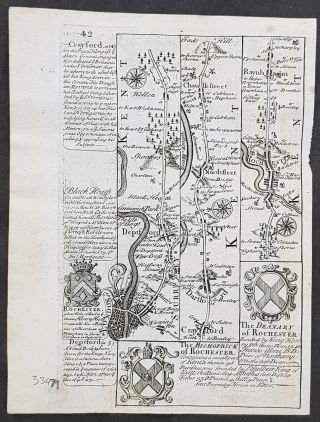
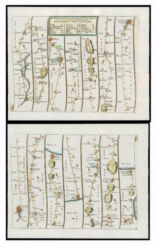
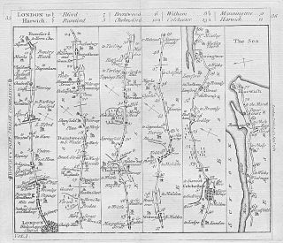
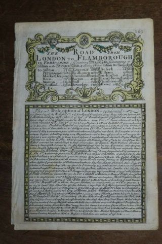
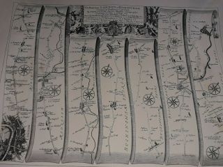
On offer: an original (i.e. not a later reproduction) antique map "The Road from London to Bristol.". Uncoloured as issued.
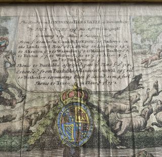
A road strip map based on Ogilby's surveyed Roads from London to Bristol. The front showing the road from London via Brentford, Maidenhead, Reading, Newbury, Hungerford to Marlborough. The back showing the continuation from Marlborough to Bristol and the branch to Bath. DATE PRINTED: 1719 or shortly afterwards. The first edition w...as issued at this date although further issues continued to the mid 18th century. SIZE: The printed area including titles is approximately 21.5 x 16 cm, 8.5 x 6.25 inches (medium) plus margins.PROVENANCE: Published by John Senex c1757 based on the earlier John Ogilby maps, for The Roads through England Delineated, or Ogilby’s Survey, Revised, Improved & Reduced to a Size Portable for the Pocket by John Senex, F.R.S. Being an Actual Survey of all the Principal Roads of England, and Wales, Distinctly laid down on one hundred & one Copper Plates on which are delineated all the cities, Towns, villages, Hills, Rivers, Brooks, Churches, capital Seats, and every place worthy of Note, throughout each ROAD; WITH The Addition of some roads newly drawn, which were omitted by Mr Ogilby, and Several necessary Corrections made in others; Together with a great number of explanatory references, by whicvh this Edition of the Roads is render'd of more general Use for TRAVELLERS. - Printed for John Bowles and Son at the Black Horse in Cornhill London.TYPE: Antique copper plate engraving printed on paper. VERSO: There is a continuation of the map printed on the reverse side. CONDITION: Good. Suitable for framing. Please check the scan for any blemishes prior to making your purchase. Virtually all antiquarian maps and prints are subject to some normal aging due to use and time which is not significant unless otherwise stated. AUTHENTICITY: This is an authentic antique print, published at the date stated above. I do not offer reproductions. It is not a modern copy. The term 'original' when applied to a print means that it was printed at the first or original date of publication; it does not imply that the item is unique. RETURNS POLICY: I offer a no questions returns policy. All I ask is that you pay return shipping and mail back to me in original condition. BACKGROUND INFORMATION: John Senex produced a vast array of cartography, from maps of the world and the continents as well as individual country maps of phenomenal detail. But it is for his road maps that he is best known, to wit, 1719 saw his small version of John Ogilby's Britannia: a series of superb strip maps, larger than Owen & Bowen's, smaller than Thomas Gardner's. It ran through many editions and is widely collected.Please explore my ebay shop for more antique prints.
Track Page Views With
Auctiva's FREE Counter