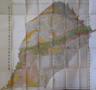
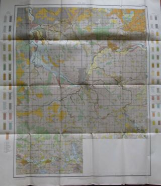
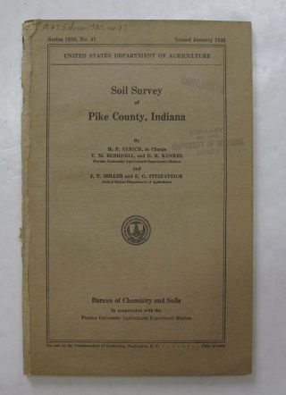
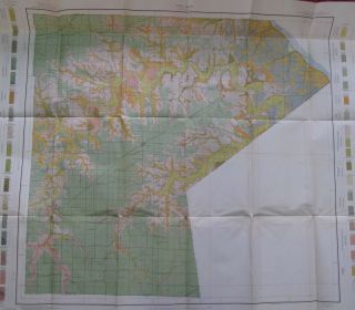
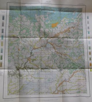
Folded Color Soil Survey Map Delaware County Indiana Center Eaton Albany 1913


Item History & Price

Information:
Reference Number: Avaluer:48249290Type: Map
Original/Reproduction: OriginalMaker: US Department of Agriculture
Original Description:
 We are offering a folded, color, soil survey map of Delaware County, Indiana. This map is in Very Good condition, with some light wear at the folds. The map shows Center, Eaton, Albany, Yorktown, and more.

Shipping Anywhere In The United States Media Mail $4; International Shipping $20.Please Note: We accept PayPal, but also accept all credit cards. Everything we sell is Returnable for any reason. We only ask for prompt notification, within 14 days.

We generally do ...try to "combine shipping" when you purchase more than one item--except in cases of large lots or very heavy shipments.

ON INTERNATIONAL ORDERS, WE DO REFUND ON OVERCHARGES!! Don't hesitate to ask for more info/detail on any of our listings.HOFFMAN BOOKS, ABAA, IOBA

THIS IS AN ORIGINAL PRINTING - NOT A MODERN REPRODUCTION. 


    Similar items


  • Folded Color Soil Survey Map Chester County Pennsylvania Coatesville Oxford 1905

    Folded Color Soil Survey Map Chester County Pennsylvania Coatesville Oxford 1905

  • Folded Color Soil Survey Map Genesee County Michigan Flint Fenton Flushing 1912

    Folded Color Soil Survey Map Genesee County Michigan Flint Fenton Flushing 1912

  • Folded Color Soil Survey Map Kingman County,  Kansas Cunningham Nashville Norwich

    Folded Color Soil Survey Map Kingman County, Kansas Cunningham Nashville Norwich

  • Folded Color Soil Survey Map Mason County Michigan Ludington Scottville Custer

    Folded Color Soil Survey Map Mason County Michigan Ludington Scottville Custer

  • Color Soil Survey Map Pike County Indiana Petersburg Winslow Spurgeon 1938

    Color Soil Survey Map Pike County Indiana Petersburg Winslow Spurgeon 1938

  • Folded Color Soil Survey Map Ralls County Missouri London Center Perry 1913

    Folded Color Soil Survey Map Ralls County Missouri London Center Perry 1913

  • Folded Color Soil Survey Map Marion County Kansas Florence Peabody Hillsboro

    Folded Color Soil Survey Map Marion County Kansas Florence Peabody Hillsboro

  • Folded Soil Survey Map Montgomery County Indiana Crawfordsville Ladoga Waynetown

    Folded Soil Survey Map Montgomery County Indiana Crawfordsville Ladoga Waynetown


    • You might also like


    • 1860 Mitchell Hand Colored Map Colorado,  Nebraska & Kansas - Civil War Era

      1860 Mitchell Hand Colored Map Colorado, Nebraska & Kansas - Civil War Era

    • 18th Century French Map Of North America

      18th Century French Map Of North America

    • Las Vegas Nevada Vintage 1967 Us Geological Survey Quadrangle Map 4 Panels

      Las Vegas Nevada Vintage 1967 Us Geological Survey Quadrangle Map 4 Panels

    • Rare Antique 1845 Maps United States Exploring Expedition Book Antartica Hawaii

      Rare Antique 1845 Maps United States Exploring Expedition Book Antartica Hawaii

    • Vintage 1926 Map Hollywood From The Best Surveys Of The Time

      Vintage 1926 Map Hollywood From The Best Surveys Of The Time

    • American Continent (western Hemisphere) 1747 Bowen Antique Copper Engraved Map

      American Continent (western Hemisphere) 1747 Bowen Antique Copper Engraved Map

    • Gulf Coast Florida Texas United States 1705 De Fer Unusual Antique Engraved Map

      Gulf Coast Florida Texas United States 1705 De Fer Unusual Antique Engraved Map

    • California As Island United States 1700 De Fer Unusual First Edition Antique Map

      California As Island United States 1700 De Fer Unusual First Edition Antique Map

Avaluer          About Us          Privacy Policy          Contact Us          UP
© 2022, avaluer.net, Inc. or its affiliates