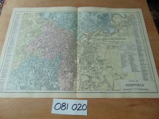
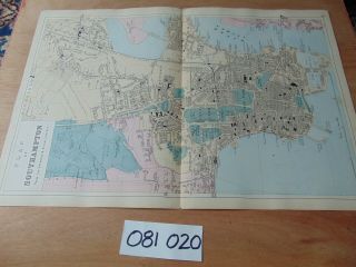
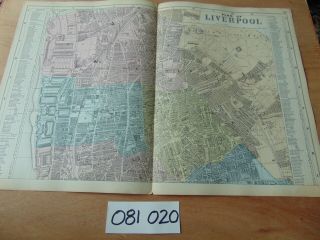
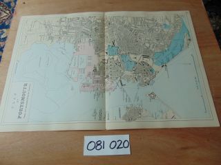
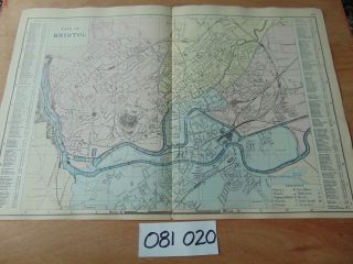
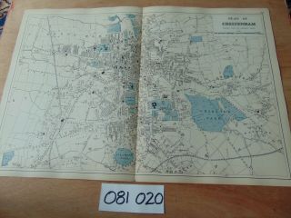
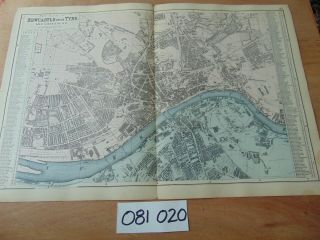
19th CENTURY 1889 ANTIQUE BACON MAP PLAN OF EDINBURGH SCOTLAND 71


Item History & Price

Information:
Reference Number: Avaluer:48252654
Original Description:
USED ORIGINAL 19th CENTURY 1889 ANTIQUE BACON MAP SIZE 20.25 x 13.5 INCHESMINOR TEARS WOULD LOOK GREAT FRAMED
HAPPY TO SHIP WORLDWIDE AND REDUCE POSTAGE FOR MULTIPLE PURCHASESPLEASE SEE OUR CLEAR PHOTO'sGET IT FAST ALL OUR ITEMS ARE DELIVERED PROMPTLY AND WELL PROTECTEDTERMS AND CONDITIONS All winning bidders enter a legally binding contract to buy the item / items won and agree in full to these Terms & Conditions. The Buyer is responsible for all for all Postage &... Packing costs shown on the auction (e.& o.e). All payments are non negotiable and must be payed in full and cleared before items are shipped. Please ensure that your Ebay and Paypal details are correct before payment is madeReturns Policy AUCTION ITEMS - ALL ITEMS ARE SOLD "AS IS" AND RETURNS ARE NOT ACCEPTED


    Similar items


  • 19th Century 1889 Antique Bacon Map Plan Of Sheffield 87

    19th Century 1889 Antique Bacon Map Plan Of Sheffield 87

  • 19th Century 1889 Antique Bacon Map Plan Of Southampton 88

    19th Century 1889 Antique Bacon Map Plan Of Southampton 88

  • 19th Century 1889 Antique Bacon Map Plan Of Liverpool 80

    19th Century 1889 Antique Bacon Map Plan Of Liverpool 80

  • 19th Century 1889 Antique Bacon Map Plan Of Portsmouth 86

    19th Century 1889 Antique Bacon Map Plan Of Portsmouth 86

  • 19th Century 1889 Antique Bacon Map Plan Of Bristol 67

    19th Century 1889 Antique Bacon Map Plan Of Bristol 67

  • 19th Century 1889 Antique Bacon Map Plan Of Cheltenham 69

    19th Century 1889 Antique Bacon Map Plan Of Cheltenham 69

  • 19th Century 1889 Antique Bacon Map Plan Of Newcastle Upon Tyne 83

    19th Century 1889 Antique Bacon Map Plan Of Newcastle Upon Tyne 83


    • You might also like


    • Hungary & Romania 1579 (1584) Ortelius Unusual Antique Copper Engraved Map

      Hungary & Romania 1579 (1584) Ortelius Unusual Antique Copper Engraved Map

    • Brussels Bruxelles Belfium 1777 De Ferraris & Dupuis Large Antique Map Sheet Xxi

      Brussels Bruxelles Belfium 1777 De Ferraris & Dupuis Large Antique Map Sheet Xxi

    • 1616 Atlas Map Of Iceland.

      1616 Atlas Map Of Iceland.

    • Kazan Russia 1767 Le Clerc/lespinasse Antique Copper Engraved City View

      Kazan Russia 1767 Le Clerc/lespinasse Antique Copper Engraved City View

    • 1899 Stanford,  Folding Map Of Norwich,  Norfolk,  Arthur Collins,  Jarrold & Sons,

      1899 Stanford, Folding Map Of Norwich, Norfolk, Arthur Collins, Jarrold & Sons,

    • 1948 Vintage Linen Colour Map Geological Survey Ten Mile Of Great Britain

      1948 Vintage Linen Colour Map Geological Survey Ten Mile Of Great Britain

    • 1944 Map Flying Bombs Sussex Ww2 Newspaper Military Kent Courier German V1 V2

      1944 Map Flying Bombs Sussex Ww2 Newspaper Military Kent Courier German V1 V2

    • Dated 1638 Vellum Map Of Icklesham Sussex Showing Land Uses Owners Etc

      Dated 1638 Vellum Map Of Icklesham Sussex Showing Land Uses Owners Etc

Avaluer          About Us          Privacy Policy          Contact Us          UP
© 2022, avaluer.net, Inc. or its affiliates