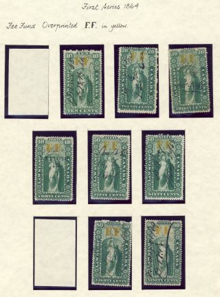
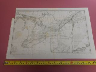
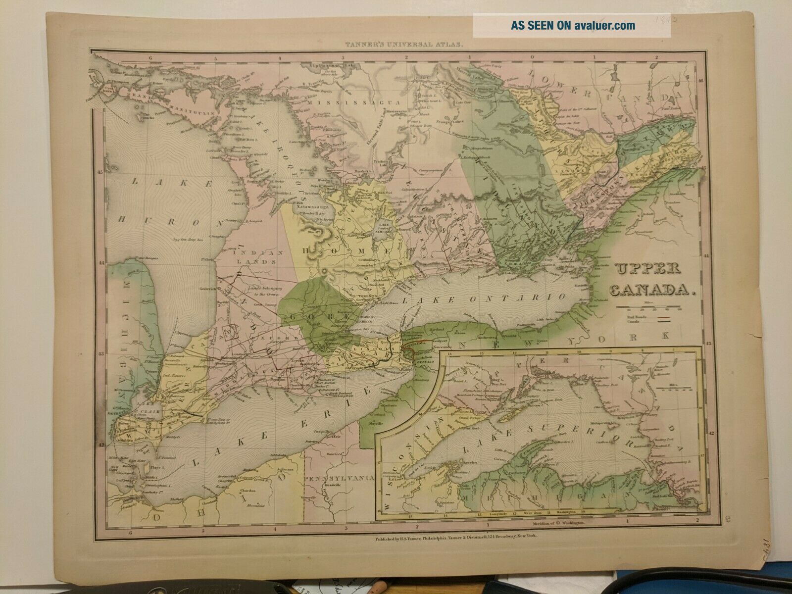
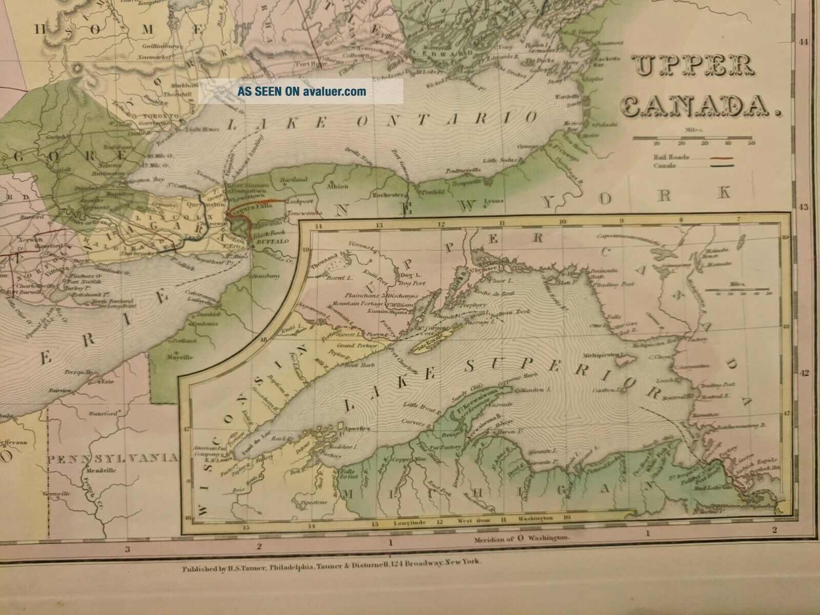
1843 Tanner: Map Of Upper Canada, Ontario, Lake Superior


Item History & Price

Information:
Reference Number: Avaluer:48257453Cartographer/Publisher: Henry Tanner
Format: Atlas MapPrinting Technique: Copper Plate
Year: 1843Original/Reproduction: Antique Original
Date Range: 1800-1899Canadian Province: Ontario
Country/Region: Canada
Original Description:
Fine, original, copper-engraved map of Upper Canada, largely Ontario, with an inset map of Lake Superior, by Henry S. Tanner, from the New Universal Atlas: Philadelphia, 1843. This original antique map of Upper Canada or Ontario comes from the 2nd edition of the New Universal Atlas, containing maps of the various Empires, Kingdoms, States and Republics of the World by H.S. Tanner: Philadelphia, 1843. Scarce; excellent condition. Hand colored; fine, heavy paper. A few minor chips and ed...ge tears, not affecting engraved surface. A fine impression. 13 1/2" x 17" outer dimensions.


    Similar items


  • Smyth

    Smyth ' S Map Of Upper Canada. Published 1813 By Prior & Dunning 1st Ed. Cased Map

  • Uc - 14 Halfpenny Token 1832 Province Of Upper Canada Ontario Breton 732

    Uc - 14 Halfpenny Token 1832 Province Of Upper Canada Ontario Breton 732

  • 1920s Lloyd

    1920s Lloyd ' S Wall Map Of Lambton County, Ontario, Canada

  • 6x Upper Canada (ontario) Law Stamps Ls Ol - 33 - 34 - 35 - 36a - 37a - 41a Cv=$230.  00

    6x Upper Canada (ontario) Law Stamps Ls Ol - 33 - 34 - 35 - 36a - 37a - 41a Cv=$230. 00

  • 8x Upper Canada (ontario) Law Stamps Ff Ol17 - 18 - 19 - 20 - 21 - 22 - 24 - 25.  Cv=$271.  00

    8x Upper Canada (ontario) Law Stamps Ff Ol17 - 18 - 19 - 20 - 21 - 22 - 24 - 25. Cv=$271. 00

  • 100 Townships Of Upper Canada Map By J Walker C1835

    100 Townships Of Upper Canada Map By J Walker C1835

  • Champlain Oil Circa 195? Road Map Of Quebec/eastern Ontario

    Champlain Oil Circa 195? Road Map Of Quebec/eastern Ontario

  • 8x Upper Canada (ontario) Law Stamps Ol2,  Ol2b To Ol7 & Ol9.  Cat.  Value=$165.  00

    8x Upper Canada (ontario) Law Stamps Ol2, Ol2b To Ol7 & Ol9. Cat. Value=$165. 00


    • You might also like


    • 1860 Mitchell Hand Colored Map Colorado,  Nebraska & Kansas - Civil War Era

      1860 Mitchell Hand Colored Map Colorado, Nebraska & Kansas - Civil War Era

    • 18th Century French Map Of North America

      18th Century French Map Of North America

    • Las Vegas Nevada Vintage 1967 Us Geological Survey Quadrangle Map 4 Panels

      Las Vegas Nevada Vintage 1967 Us Geological Survey Quadrangle Map 4 Panels

    • Rare Antique 1845 Maps United States Exploring Expedition Book Antartica Hawaii

      Rare Antique 1845 Maps United States Exploring Expedition Book Antartica Hawaii

    • Vintage 1926 Map Hollywood From The Best Surveys Of The Time

      Vintage 1926 Map Hollywood From The Best Surveys Of The Time

    • American Continent (western Hemisphere) 1747 Bowen Antique Copper Engraved Map

      American Continent (western Hemisphere) 1747 Bowen Antique Copper Engraved Map

    • Gulf Coast Florida Texas United States 1705 De Fer Unusual Antique Engraved Map

      Gulf Coast Florida Texas United States 1705 De Fer Unusual Antique Engraved Map

    • California As Island United States 1700 De Fer Unusual First Edition Antique Map

      California As Island United States 1700 De Fer Unusual First Edition Antique Map

Avaluer          About Us          Privacy Policy          Contact Us          UP
© 2022, avaluer.net, Inc. or its affiliates