1759 BELLIN Atlas Map ICELAND - Carte De L ' Islande M Horrebows - Islande


Item History & Price

Information:
Reference Number: Avaluer:48258915Printing Technique: Copper Plate
Antique: YesOriginal/Reproduction: Antique Original
Date Range: 1700-1799Year: 1759
Era: 1700s
Original Description:
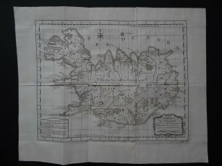
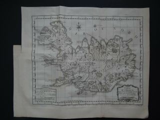
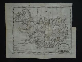
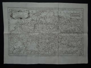
Map title:Carte de L'IslandeDressee sur celle de M. Horrebows
A rare antique folding map of Icelandby Jacques Nicolas Bellin, drawn from work by Niels Horrebowc1759
From the book:Histoire Generale des Voyagesby Prevost See pictures
Page size 42 x 38.5 cmMap is in good condition for its age, engravings are clearPage has a little marginal browning and handling marksText in FrenchFold lines as issuedBlank on reverseUncoloured
Payments by Paypal please.UK postage £5.50Eur...ope £11.99Worldwide £12.99


    Similar items


  • 1758 Bellin Atlas Map Iceland - Carte De L

    1758 Bellin Atlas Map Iceland - Carte De L ' Islande - Horrebows

  • 1770 Bellin Atlas Map Iceland - Carte De L

    1770 Bellin Atlas Map Iceland - Carte De L ' Islande

  • 1780 Bellin Atlas Map Iceland - Carte De L

    1780 Bellin Atlas Map Iceland - Carte De L ' Islande - Horrebows

  • 1752 Bellin Atlas Map Japan - Carte De L

    1752 Bellin Atlas Map Japan - Carte De L ' Empire Du Japon

  • 1758 Bellin Atlas Map Siberia - Carte De La Siberie

    1758 Bellin Atlas Map Siberia - Carte De La Siberie

  • 1754 Bellin Atlas Map Mexico - Carte De L

    1754 Bellin Atlas Map Mexico - Carte De L ' Empire Du Mexique

  • 1750 Bellin Atlas Map Maldives - Carte Des Isles Maldives

    1750 Bellin Atlas Map Maldives - Carte Des Isles Maldives

  • 1758 Bellin Atlas Map Jamaica - Carte De L

    1758 Bellin Atlas Map Jamaica - Carte De L ' Isle De La Jamaique - Caribbean


    • You might also like


    • Hungary & Romania 1579 (1584) Ortelius Unusual Antique Copper Engraved Map

      Hungary & Romania 1579 (1584) Ortelius Unusual Antique Copper Engraved Map

    • Brussels Bruxelles Belfium 1777 De Ferraris & Dupuis Large Antique Map Sheet Xxi

      Brussels Bruxelles Belfium 1777 De Ferraris & Dupuis Large Antique Map Sheet Xxi

    • 1616 Atlas Map Of Iceland.

      1616 Atlas Map Of Iceland.

    • Kazan Russia 1767 Le Clerc/lespinasse Antique Copper Engraved City View

      Kazan Russia 1767 Le Clerc/lespinasse Antique Copper Engraved City View

    • 1899 Stanford,  Folding Map Of Norwich,  Norfolk,  Arthur Collins,  Jarrold & Sons,

      1899 Stanford, Folding Map Of Norwich, Norfolk, Arthur Collins, Jarrold & Sons,

    • 1948 Vintage Linen Colour Map Geological Survey Ten Mile Of Great Britain

      1948 Vintage Linen Colour Map Geological Survey Ten Mile Of Great Britain

    • 1944 Map Flying Bombs Sussex Ww2 Newspaper Military Kent Courier German V1 V2

      1944 Map Flying Bombs Sussex Ww2 Newspaper Military Kent Courier German V1 V2

    • Dated 1638 Vellum Map Of Icklesham Sussex Showing Land Uses Owners Etc

      Dated 1638 Vellum Map Of Icklesham Sussex Showing Land Uses Owners Etc

Avaluer          About Us          Privacy Policy          Contact Us          UP
© 2022, avaluer.net, Inc. or its affiliates