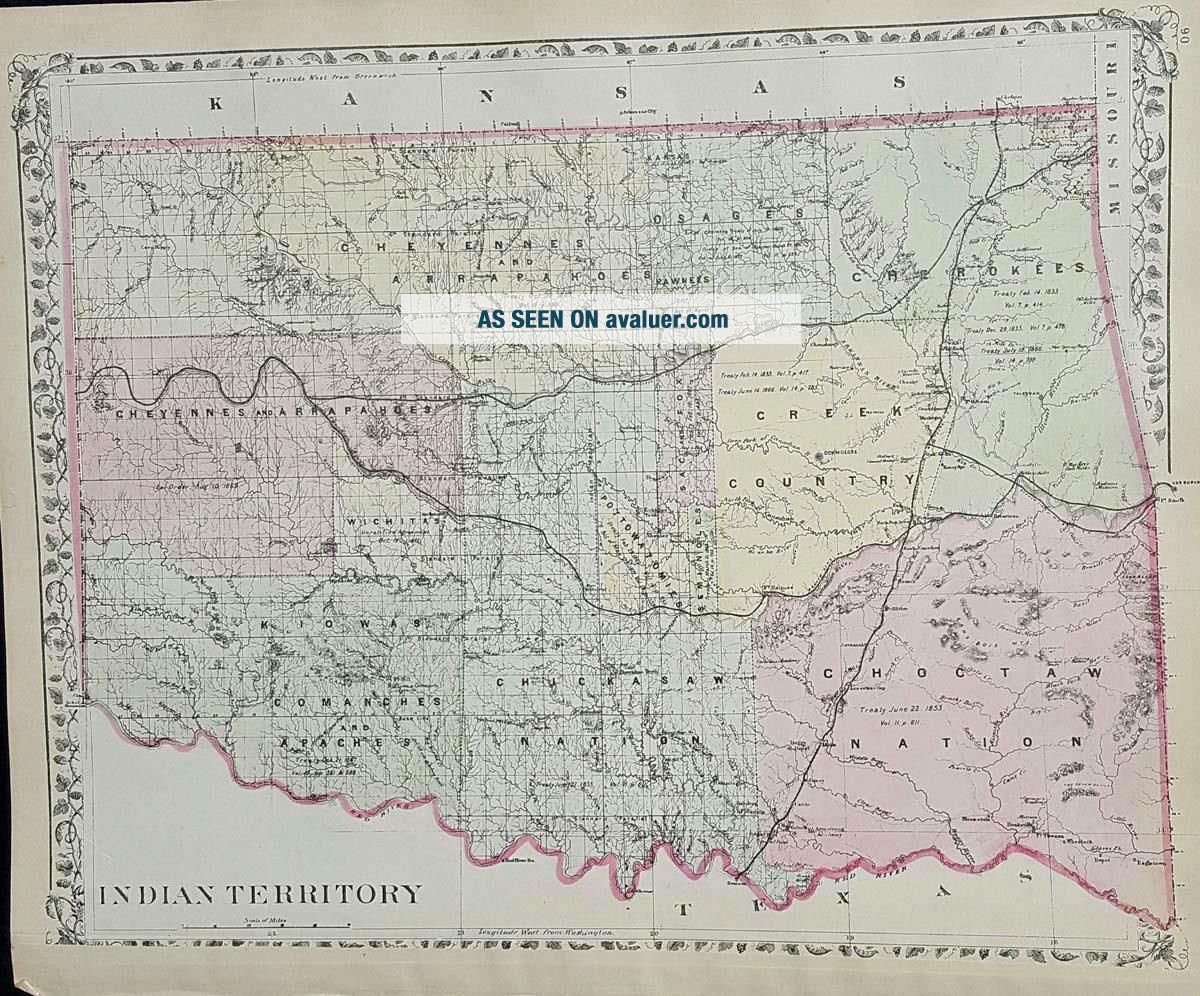
Map Of Colorado And Indian Territories Augustus Mitchell C 1881.


Item History & Price

Information:
Reference Number: Avaluer:51833
Original Description:
     Title: Map of Colorado and Indian Territories
Mapmaker: Augustus Mitchell
Atlas of the World: c1881
Condition:  Very good
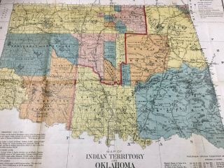
  Single page printed both sides. On side 1 a map of Colorado and on the other side a map of the Indian Territories between Kansas and Texas from Mitchell's Atlas of the World c. 1881. 12" x 15". Very good+
Whitlock's is an antiquarian and rare book store that a...lso sells old maps, prints, and ephemera. Those who treasure the past, will delight in our selection of old maps from the 1800's. We have 1000's of maps by town and by county from 21 states. Maps in the collection include maps by Mitchell, Colton, Tilden & Baker, and the Beers family. We also have a limited selection of international maps.    


    Similar items


  • Map Of Oklahoma And Indian Territory,  J.  Bien 1890 Native American

    Map Of Oklahoma And Indian Territory, J. Bien 1890 Native American

  • Antique 1873 Map Of Texas And Indian Territory

    Antique 1873 Map Of Texas And Indian Territory

  • Map Of Oklahoma And Indian Territory And Map Of Arizona/ Mexico,  1897

    Map Of Oklahoma And Indian Territory And Map Of Arizona/ Mexico, 1897

  • Vintage Color State Map Of Oklahoma (and Indian Territory) Ca.  1903 Small Map

    Vintage Color State Map Of Oklahoma (and Indian Territory) Ca. 1903 Small Map

  • 1870 Antique Map Print Of Texas And Indian Territory

    1870 Antique Map Print Of Texas And Indian Territory

  • Antique Map Of Texas,  Oklahoma & Indian Territory And Kansas On The Reverse/1900

    Antique Map Of Texas, Oklahoma & Indian Territory And Kansas On The Reverse/1900

  • 1877 Hand - Colored Map Of Texas,  Louisiana,  Indian Territory,  Arkansas

    1877 Hand - Colored Map Of Texas, Louisiana, Indian Territory, Arkansas

  • Antique Map " Map Of Choctaw Nation Indian Territory " 1903

    Antique Map " Map Of Choctaw Nation Indian Territory " 1903


    • You might also like


    • 1860 Mitchell Hand Colored Map Colorado,  Nebraska & Kansas - Civil War Era

      1860 Mitchell Hand Colored Map Colorado, Nebraska & Kansas - Civil War Era

    • 18th Century French Map Of North America

      18th Century French Map Of North America

    • Las Vegas Nevada Vintage 1967 Us Geological Survey Quadrangle Map 4 Panels

      Las Vegas Nevada Vintage 1967 Us Geological Survey Quadrangle Map 4 Panels

    • Rare Antique 1845 Maps United States Exploring Expedition Book Antartica Hawaii

      Rare Antique 1845 Maps United States Exploring Expedition Book Antartica Hawaii

    • Vintage 1926 Map Hollywood From The Best Surveys Of The Time

      Vintage 1926 Map Hollywood From The Best Surveys Of The Time

    • American Continent (western Hemisphere) 1747 Bowen Antique Copper Engraved Map

      American Continent (western Hemisphere) 1747 Bowen Antique Copper Engraved Map

    • Gulf Coast Florida Texas United States 1705 De Fer Unusual Antique Engraved Map

      Gulf Coast Florida Texas United States 1705 De Fer Unusual Antique Engraved Map

    • California As Island United States 1700 De Fer Unusual First Edition Antique Map

      California As Island United States 1700 De Fer Unusual First Edition Antique Map

Avaluer          About Us          Privacy Policy          Contact Us          UP
© 2022, avaluer.net, Inc. or its affiliates