EUROPE BY JOHN SENEX C1740 ANTIQUE COPPER ENGRAVED MAP

Item History & Price
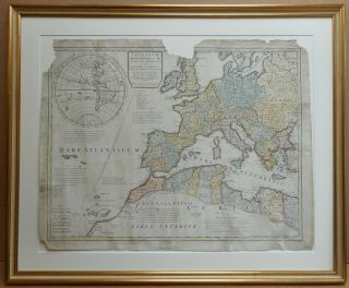
EUROPE BY JOHN SENEX c1740
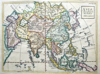
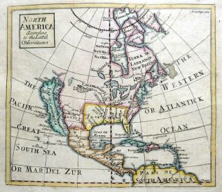
EUROPE BY JOHN SENEX c1740 Click image to enlarge Description EUROPE
ACCORDING TO THE LATEST
OBSERVATIONS
BYJOHN SENEX c1740 PRODUCED FOR
PATRICK GORDON'S
GEOGRAPHY ANATOMIZ'D
PUBLISHED LONDON
1740...r />
GENUINE COPPER ENGRAVED MAP WITH HAND COLOUR
THIS 1740 MAP IS IN EXCELLENT CONDITION WITH A GOOD CLEAR IMPRESSION AND HAND COLOUR.
THERE ARE TWO FEINT FOLD CREASES AS PUBLISHED.THIS IS A GENUINE ANTIQUE MAP OVER 270 YEARS OLD.THE MAP MEASURES APPROX 7.25 x 6.25 ins (18.5 x 15.5 cms) PLUS GOOD MARGINS.
JOHN SENEX (1678-1740) WAS A LONDON BASED MAPSELLER, GLOBEMAKER, ENGRAVER & SURVEYOR WHO WAS GEOGRAPHER TO THE QUEEN. THROUGHOUT HIS LIFE HE PRODUCED A VAST AMOUNT OF MAPS & GLOBES COVERING THE WORLD. Payment PAYMENT BY PAYPAL PREFERRED. ONLY CHEQUES DRAWN ON UK BANKS ACCEPTED. ITEMS WILL BE DISPATCHED ON RECEIPT OF PAYMENT BY PAYPAL OR RECEIPT OF CHEQUE, AFTER CLEARING AT BANK.
Shipping POSTAGE & PACKING IS FREE OF CHARGE WITHIN THE UK. INTERNATIONAL POSTAGE IS CHARGED AT £8 WORLDWIDE ALL ITEMS WILL BE SENT BY ROYAL MAIL WITH PROOF OF POSTING.SPECIAL DELIVERY/ INSURED CAN BE ARRANGED. About Us ESTABLISHED IN 1998 WE ARE AN ANTIQUE MAP & PRINT BUSINESS THAT ONLY SELL GENUINE ANTIQUES. ALL OUR MAPS, PRINTS & ENGRAVINGS ARE GUARANTEED TO HAVE BEEN PRODUCED AT OR AROUND THE DATE STATED.WE WILL GLADLY OFFER A FULL REFUND IF YOUR PURCHASE IS NOT AS DESCRIBED, & IS RETURNED IN THE SAME CONDITION AS DISPATCHED WITHIN 30 DAYS.
Images sell!
Get Supersized Images & Free Image HostingCreate your brand with Auctiva's
Customizable Templates.
Attention Sellers - Get Templates
Image Hosting, Scheduling at Auctiva.com.
Track Page Views With
Auctiva's FREE Counter
EUROPE BY JOHN SENEX c1740 Click image to enlarge Description EUROPE
ACCORDING TO THE LATEST
OBSERVATIONS
BYJOHN SENEX c1740 PRODUCED FOR
PATRICK GORDON'S
GEOGRAPHY ANATOMIZ'D
PUBLISHED LONDON
1740
GENUINE COPPER ENGRAVED MAP WITH HAND COLOUR
THIS 1740 MAP IS IN EXCELLENT CONDITION WITH A GOOD CLEAR IMPRESSION AND HAND COLOUR.
THERE ARE TWO FEINT FOLD CREASES AS PUBLISHED.THIS IS A GENUINE ANTIQUE MAP OVER 270 YEARS OLD.THE MAP MEASURES APPROX 7.25 x 6.25 ins (18.5 x 15.5 cms) PLUS GOOD MARGINS.
JOHN SENEX (1678-1740) WAS A LONDON BASED MAPSELLER, GLOBEMAKER, ENGRAVER & SURVEYOR WHO WAS GEOGRAPHER TO THE QUEEN. THROUGHOUT HIS LIFE HE PRODUCED A VAST AMOUNT OF MAPS & GLOBES COVERING THE WORLD. Payment PAYMENT BY PAYPAL PREFERRED. ONLY CHEQUES DRAWN ON UK BANKS ACCEPTED. ITEMS WILL BE DISPATCHED ON RECEIPT OF PAYMENT BY PAYPAL OR RECEIPT OF CHEQUE, AFTER CLEARING AT BANK.
Shipping POSTAGE & PACKING IS FREE OF CHARGE WITHIN THE UK. INTERNATIONAL POSTAGE IS CHARGED AT £8 WORLDWIDE ALL ITEMS WILL BE SENT BY ROYAL MAIL WITH PROOF OF POSTING.SPECIAL DELIVERY/ INSURED CAN BE ARRANGED. About Us ESTABLISHED IN 1998 WE ARE AN ANTIQUE MAP & PRINT BUSINESS THAT ONLY SELL GENUINE ANTIQUES. ALL OUR MAPS, PRINTS & ENGRAVINGS ARE GUARANTEED TO HAVE BEEN PRODUCED AT OR AROUND THE DATE STATED.WE WILL GLADLY OFFER A FULL REFUND IF YOUR PURCHASE IS NOT AS DESCRIBED, & IS RETURNED IN THE SAME CONDITION AS DISPATCHED WITHIN 30 DAYS.
Images sell!
Get Supersized Images & Free Image HostingCreate your brand with Auctiva's
Customizable Templates.
Attention Sellers - Get Templates
Image Hosting, Scheduling at Auctiva.com.
Track Page Views With
Auctiva's FREE Counter