BASQUE COUNTRY - LA SIERRA DE SAINT ADRIAN EN BISCAIA BY BRAUN AND HOGENBERG.


Item History & Price

Information:
Reference Number: Avaluer:52871
Original Description:

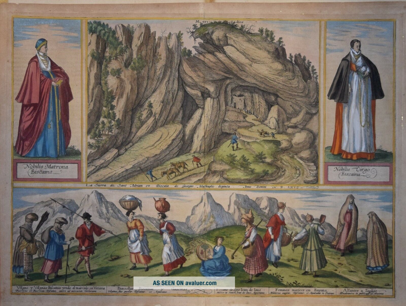
LA SIERRA DE SAINT ADRIAN EN BISCAIA.
Decorative copper engraving showing Biscay inhabitants by Georg Hoefnagel,  produced to accompany Braun & Hogenberg's "Civitates Orbis Terrarum". The present map was first published circa 1596. Latin text on verso.
One mountain view, two costumed figures and a country scene of Biscayan peasants going to market in Vitoria and other costumed locals.

COMMENTARY BY BRAUN: "Spain is mountainous almost eve...rywhere, but the Pyrenees surpass the other ranges in breadth and length. And since there are very many experienced miners in Spain, they have been able to survey the rocks, dig tunnels and thereby make it possible to pass through. A particularly fine example can be seen in this place in the Pyrenees, on the border of Spain and France. In the mountain of St Adrian, on the road that leads to France, there is a tunnel through which travellers can pass backwards and forwards." 

Presented across this double page is a rocky landscape in the western foothills of the Pyrenees, south of the Bay of Biscay between San Sebastian and Vitoria-Gasteiz, capital of the province of Alava. A natural cave carved out of the rock by water was enlarged to create a tunnel easily large enough for pedestrian traffic between Spain and France, on a section of the way of St James. As one of the central routes through the Pyrenees, the tunnel was heavily used from the 15th to the 18th century. In the 16th century an inn for pilgrims opened inside the tunnel; on the French side, which was shut with gates at night, a toll post was established. Only in the 18th century, when the king of Spain built a paved road from Madrid to France, did the volume of traffic through the San Adrian tunnel start to decline. Illustrated on either side of the picture of the tunnel entrance and in the lower half of the plate are a number of costumed figures in traditional dress: on the left a noble Biscayan matron, on the right a noble Biscayan maiden and below (from left to right): a Biscayan peasant man and women on the way to market in Vitoria / Biscayan and Gascon maidens or girls / Woman from Saint-Jean-de-Luz, Aquitaine / Married Biscayan and Gascon women from Bayonne / Women on the way to church in Bayonne. (Taschen)

Measures 350 x 485 mm. Some strengthening at lower border, well away from the printed surface. Otherwise very good.
Attractive hand colour.
A genuine antique map.


    Similar items


  • 1900 Paris Exhibition Universelle La Republic De Saint - Marin San Marino – Udb

    1900 Paris Exhibition Universelle La Republic De Saint - Marin San Marino – Udb

  • France Postcard - Chambord - Le Chateau Vu De La Route De Saint - Die B1052

    France Postcard - Chambord - Le Chateau Vu De La Route De Saint - Die B1052

  • Syria Old Postcard Middle East Mur De La Fuite De Saint Paul,  Damascus

    Syria Old Postcard Middle East Mur De La Fuite De Saint Paul, Damascus

  • Picture Postcard - Bayeux,  Maisons De La Rue De Saint - Martin

    Picture Postcard - Bayeux, Maisons De La Rue De Saint - Martin

  • France Aigues Mortes La Statue De Saint Louis Monument

    France Aigues Mortes La Statue De Saint Louis Monument

  • Moving Art Van Gogh Le Jardin De La Maison De Sainte 22x28 Print Popular

    Moving Art Van Gogh Le Jardin De La Maison De Sainte 22x28 Print Popular

  • Antique Map " Carte De La Partie De Saint Domingue,  Habitee Par Les Francois "

    Antique Map " Carte De La Partie De Saint Domingue, Habitee Par Les Francois "

  • Histoire De La Paroisse De Saint - Augustin (portneuf) Bechard 1885

    Histoire De La Paroisse De Saint - Augustin (portneuf) Bechard 1885


    • You might also like


    • Hungary & Romania 1579 (1584) Ortelius Unusual Antique Copper Engraved Map

      Hungary & Romania 1579 (1584) Ortelius Unusual Antique Copper Engraved Map

    • Brussels Bruxelles Belfium 1777 De Ferraris & Dupuis Large Antique Map Sheet Xxi

      Brussels Bruxelles Belfium 1777 De Ferraris & Dupuis Large Antique Map Sheet Xxi

    • 1616 Atlas Map Of Iceland.

      1616 Atlas Map Of Iceland.

    • Kazan Russia 1767 Le Clerc/lespinasse Antique Copper Engraved City View

      Kazan Russia 1767 Le Clerc/lespinasse Antique Copper Engraved City View

    • 1899 Stanford,  Folding Map Of Norwich,  Norfolk,  Arthur Collins,  Jarrold & Sons,

      1899 Stanford, Folding Map Of Norwich, Norfolk, Arthur Collins, Jarrold & Sons,

    • 1948 Vintage Linen Colour Map Geological Survey Ten Mile Of Great Britain

      1948 Vintage Linen Colour Map Geological Survey Ten Mile Of Great Britain

    • 1944 Map Flying Bombs Sussex Ww2 Newspaper Military Kent Courier German V1 V2

      1944 Map Flying Bombs Sussex Ww2 Newspaper Military Kent Courier German V1 V2

    • Dated 1638 Vellum Map Of Icklesham Sussex Showing Land Uses Owners Etc

      Dated 1638 Vellum Map Of Icklesham Sussex Showing Land Uses Owners Etc

Avaluer          About Us          Privacy Policy          Contact Us          UP
© 2022, avaluer.net, Inc. or its affiliates