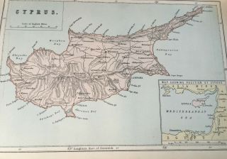
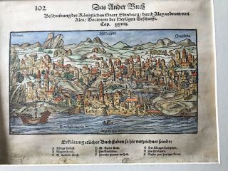
Antique Ca. 1575 Woodcut Map Of Cyprus, From Sebastian Munster ' S " Cosmographia "


Item History & Price

Information:
Reference Number: Avaluer:58931220Printing Technique: Woodcut
Original/Reproduction: Antique OriginalDate Range: 1500-1599
Cartographer/Publisher: Sebastian MunsterYear: 1575
Country/Region: Cyprus
Original Description:
Antique ca. 1575 woodcut map of Cyprus, Sebastian Munster, from a German issue of the "Cosmographia", showing Nicosia, Famagusta, Kyrenia, mountains and rivers of the island, a large vessel in full sail approaching the island. Fine condition, uncoloured, set in  a page of German text descriptions of the island, two other images showing farmers at work to top of page, and a pair of reindeer to verso. 32cm x 21cm (page). 


    Similar items


  • Antique Ca.  1860 - 1890 Map Of Paris,  Hotel De Baviere Fold - Out,  9 1/2” X 12”

    Antique Ca. 1860 - 1890 Map Of Paris, Hotel De Baviere Fold - Out, 9 1/2” X 12”

  • Antique Print C1870

    Antique Print C1870 ' S Map Of Cyprus Colour Map Of The World Europe Globe Atlas

  • Antique Japanese Woodcut Map Of Japan,  1811

    Antique Japanese Woodcut Map Of Japan, 1811

  • Antique Japanese Woodcut Map Of World,  1811

    Antique Japanese Woodcut Map Of World, 1811

  • Cyrpus Greece Greek Map Of Cyprus 1950 42x68cm

    Cyrpus Greece Greek Map Of Cyprus 1950 42x68cm

  • Antique German Woodcut Map Of Ancient Edinburgh And Leith.

    Antique German Woodcut Map Of Ancient Edinburgh And Leith.

  • Rare British Army Map Of Cyprus - Nicosia Within The Walls 1956

    Rare British Army Map Of Cyprus - Nicosia Within The Walls 1956

  • Vintage 1975 Map Of Cyprus Showing Turkish & Greeks Villages Before 2nd Invasion

    Vintage 1975 Map Of Cyprus Showing Turkish & Greeks Villages Before 2nd Invasion


    • You might also like


    • Hungary & Romania 1579 (1584) Ortelius Unusual Antique Copper Engraved Map

      Hungary & Romania 1579 (1584) Ortelius Unusual Antique Copper Engraved Map

    • Brussels Bruxelles Belfium 1777 De Ferraris & Dupuis Large Antique Map Sheet Xxi

      Brussels Bruxelles Belfium 1777 De Ferraris & Dupuis Large Antique Map Sheet Xxi

    • 1616 Atlas Map Of Iceland.

      1616 Atlas Map Of Iceland.

    • Kazan Russia 1767 Le Clerc/lespinasse Antique Copper Engraved City View

      Kazan Russia 1767 Le Clerc/lespinasse Antique Copper Engraved City View

    • 1899 Stanford,  Folding Map Of Norwich,  Norfolk,  Arthur Collins,  Jarrold & Sons,

      1899 Stanford, Folding Map Of Norwich, Norfolk, Arthur Collins, Jarrold & Sons,

    • 1948 Vintage Linen Colour Map Geological Survey Ten Mile Of Great Britain

      1948 Vintage Linen Colour Map Geological Survey Ten Mile Of Great Britain

    • 1944 Map Flying Bombs Sussex Ww2 Newspaper Military Kent Courier German V1 V2

      1944 Map Flying Bombs Sussex Ww2 Newspaper Military Kent Courier German V1 V2

    • Dated 1638 Vellum Map Of Icklesham Sussex Showing Land Uses Owners Etc

      Dated 1638 Vellum Map Of Icklesham Sussex Showing Land Uses Owners Etc

Avaluer          About Us          Privacy Policy          Contact Us          UP
© 2022, avaluer.net, Inc. or its affiliates