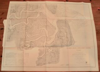
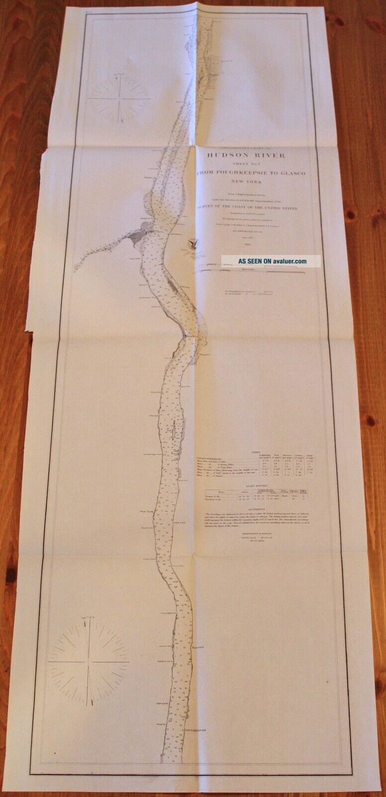
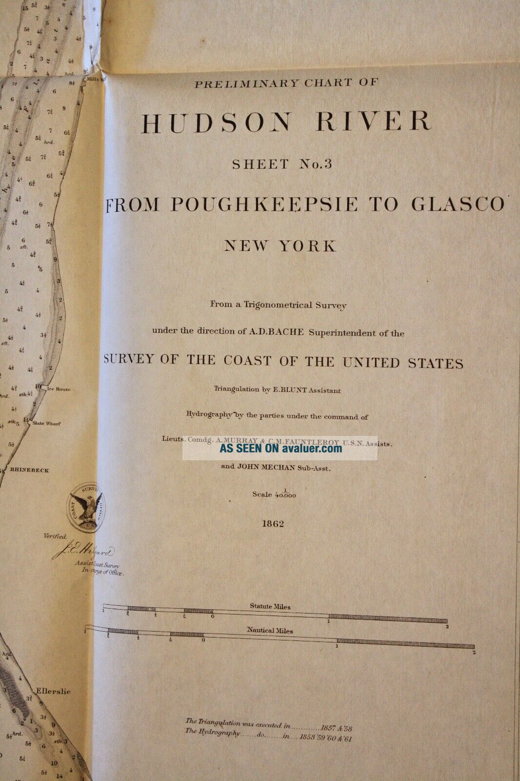
1862 US Coast Survey Map Hudson River Poughkeepsie To Glasco York


Item History & Price

Information:
Reference Number: Avaluer:58936114Cartographer/Publisher: A.D. Bache
US State: New YorkPrinting Technique: Lithography
Date Range: 1800-1899Format: Folding Map
City: PoughkeepsieType: River Map
Country/Region: United States of AmericaYear: 1862
Original Description:
US Coast Survey Preliminary Chart of Hudson River From Poughkeepsie to Glasco, New YorkSheet No. 3, Map No. 12From a Trigonometrical Survey under the direction of A.D. Bache Superintendent1862
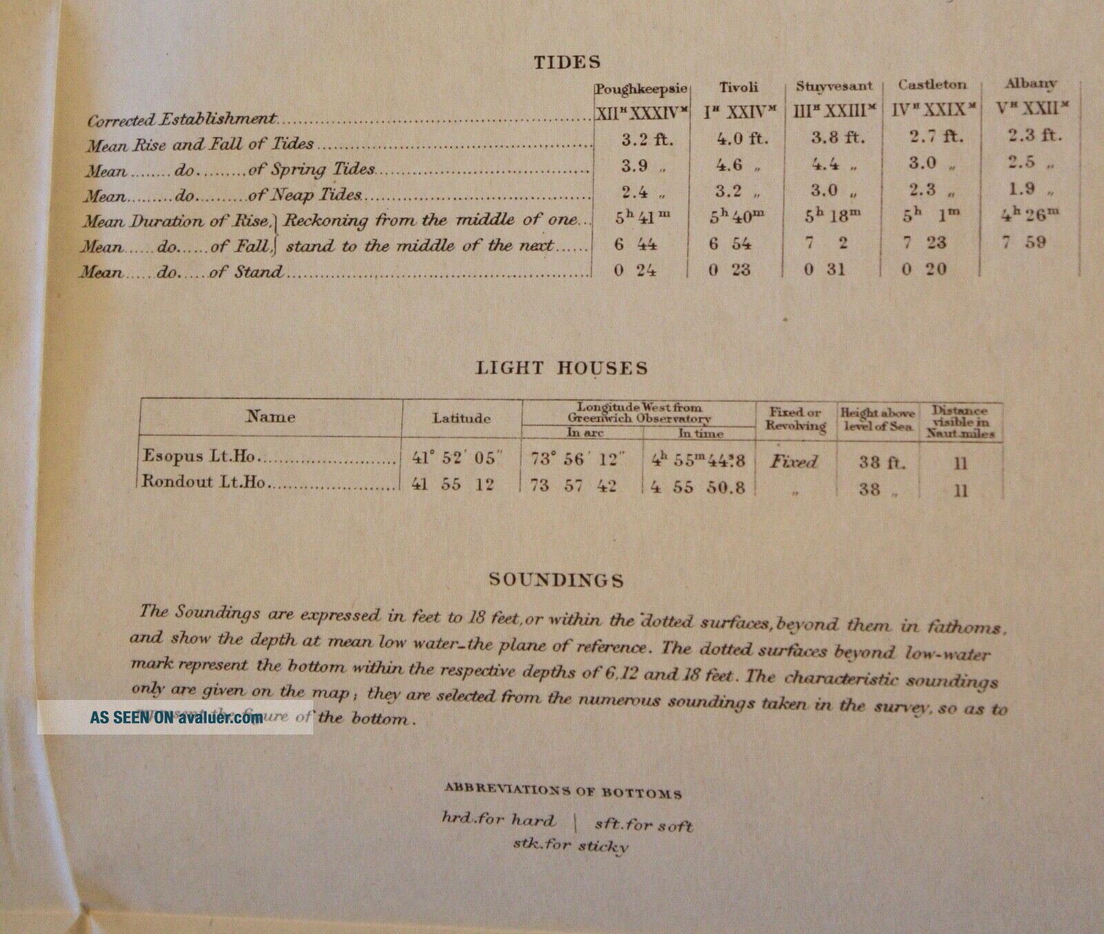
Includes Tides, Light Houses, and SoundingsVery good condition, clean and bright14-½" x 40"
Item #MCS-66
Shipping is standard post (no tracking) for Canada and US. Express, tracking, and international shipping by quote. If purchasing multiple items to be shipped together, a refund ...of additional shipping will be issued upon mailing based on the actual cost.


    Similar items


  • 1862 Us Coast Survey Map Florida St Mary

    1862 Us Coast Survey Map Florida St Mary ' S River & Fernandina Harbor

  • 1862 Us Coast Survey Map - Port Royal,  Beaufort,  Broad & Chechehessee Rivers,  Sc

    1862 Us Coast Survey Map - Port Royal, Beaufort, Broad & Chechehessee Rivers, Sc

  • 1862 Us Coast Survey Map Massachusetts,  Cape Cod,  Martha

    1862 Us Coast Survey Map Massachusetts, Cape Cod, Martha ' S Vineyard

  • 1862 Us Coast Survey Map Of Pacific,  Tillamook Bay,  Oregon,  Washington To Bc

    1862 Us Coast Survey Map Of Pacific, Tillamook Bay, Oregon, Washington To Bc

  • 1862 Us Coast Survey Map Of Upper Of Part San Francisco Bay,  California

    1862 Us Coast Survey Map Of Upper Of Part San Francisco Bay, California

  • 1862 Us Coast Survey Map South Carolina Charleston To Hilton Head,  Forts

    1862 Us Coast Survey Map South Carolina Charleston To Hilton Head, Forts

  • 1862 Us Coast Survey Map Of Oregon Inlet In North Carolina

    1862 Us Coast Survey Map Of Oregon Inlet In North Carolina

  • 1862 Us Coast Survey Map Florida St.  Augustine Harbor

    1862 Us Coast Survey Map Florida St. Augustine Harbor


    • You might also like


    • 1860 Mitchell Hand Colored Map Colorado,  Nebraska & Kansas - Civil War Era

      1860 Mitchell Hand Colored Map Colorado, Nebraska & Kansas - Civil War Era

    • 18th Century French Map Of North America

      18th Century French Map Of North America

    • Las Vegas Nevada Vintage 1967 Us Geological Survey Quadrangle Map 4 Panels

      Las Vegas Nevada Vintage 1967 Us Geological Survey Quadrangle Map 4 Panels

    • Rare Antique 1845 Maps United States Exploring Expedition Book Antartica Hawaii

      Rare Antique 1845 Maps United States Exploring Expedition Book Antartica Hawaii

    • Vintage 1926 Map Hollywood From The Best Surveys Of The Time

      Vintage 1926 Map Hollywood From The Best Surveys Of The Time

    • American Continent (western Hemisphere) 1747 Bowen Antique Copper Engraved Map

      American Continent (western Hemisphere) 1747 Bowen Antique Copper Engraved Map

    • Gulf Coast Florida Texas United States 1705 De Fer Unusual Antique Engraved Map

      Gulf Coast Florida Texas United States 1705 De Fer Unusual Antique Engraved Map

    • California As Island United States 1700 De Fer Unusual First Edition Antique Map

      California As Island United States 1700 De Fer Unusual First Edition Antique Map

Avaluer          About Us          Privacy Policy          Contact Us          UP
© 2022, avaluer.net, Inc. or its affiliates