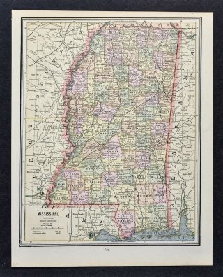
1909 George Cram Map - Mississippi - Jackson Vicksburg Natchez Biloxi Oxford MS


Item History & Price

Information:
Reference Number: Avaluer:58936204Cartographer/Publisher: George Cram
Year: 1909Publication Year: 1909
Topic: Maps
Original Description:
Lake Erie Maps & Prints Ebay Store!An Authentic Antique Map: Not a Modern Reproduction!  See Our Ebay Store for More Antique Maps!Free US Shipping on Purchases of 5 or More Maps and PrintsDescription:  It is an authentic antique map over 100 years old with ceragraphic color and a centerfold as issued.  It is by George F. Cram, Chicago Illinois, as stated in the title area of the map and is from a 1909 edition of Cram's Atlas of... the World. It is not mounted, matted nor framed being sold as a large single sheet with a centerfold as shown in the main pic. There is text on the reverse. Overall a nice antique map with the desirable egg and dart border along with the red and green outlining that is distinctive of the early Cram maps of the 1880s. A lot of nice details and topography.Size: The main map image measures approximately 13 1/2 by 20 inches (34x51cm) on a 14 1/2 by 22" (37x56cm) page with a margin all around as seen in the main pic.  Condition: The map is in Very Good to Excellent condition, basically as seen in the pics. It is very clean with no obvious defects to mention, see the pics for more on condition. The pics are of the actual map.Save on Shipping: We only charge one shipping fee based on the largest map or print with multiple items shipped along with it for no extra costs. Purchase 5 or more maps or prints and receive Free First Class shipping in USA.International Customs and VAT Fees: It is the responsibility of the buyer to pay all Customs Taxes, VAT or other fees that may be due upon arrival. These fees vary greatly from country to country and ebay policy is that the buyer is responsible for their country's taxes and fees. Please consult your country's Customs Regulations for more details on your country, printed matter is duty free in many countries. We declare the full purchase value as required by law. Delays by Customs: Although most items arrive at their destination very quickly, we have no control over how long it takes an item to move through Customs, which can be held for up to six weeks in rare cases.Satisfaction Guaranteed: We stand fully behind our products and offer a full refund minus shipping with no questions asked.Check out my other items!    Be sure to add me to your favorites list!

00111


    Similar items


  • C 1890 George Cram Map - Mississippi Jackson Vicksburg Natchez Biloxi Oxford Ms

    C 1890 George Cram Map - Mississippi Jackson Vicksburg Natchez Biloxi Oxford Ms

  • 1891 Cram Map - Mississippi Jackson Natchez Tupelo Biloxi Pascagoula Yazoo City

    1891 Cram Map - Mississippi Jackson Natchez Tupelo Biloxi Pascagoula Yazoo City

  • 1909 George Cram Map - South Carolina Charleston Columbia Beaufort Myrtle Beach

    1909 George Cram Map - South Carolina Charleston Columbia Beaufort Myrtle Beach

  • 1909 George Cram Map - Iowa - Des Moines Council Bluff Cedar Rapids Dubuque Ia

    1909 George Cram Map - Iowa - Des Moines Council Bluff Cedar Rapids Dubuque Ia

  • 1909 George Cram Map - Washington Seattle Olympia Spokane Tacoma Mt.  Rainer - Wa

    1909 George Cram Map - Washington Seattle Olympia Spokane Tacoma Mt. Rainer - Wa

  • C 1900 George Cram Map - Alabama Montgomery Birmingham Mobile Selma Florence Al

    C 1900 George Cram Map - Alabama Montgomery Birmingham Mobile Selma Florence Al

  • C 1900 George Cram Map Louisiana Orleans Baton Rouge Shreveport Lake Charles

    C 1900 George Cram Map Louisiana Orleans Baton Rouge Shreveport Lake Charles

  • C 1900 George Cram Map - Utah - Salt Lake City Provo Odgen Moab Price Heber Ut

    C 1900 George Cram Map - Utah - Salt Lake City Provo Odgen Moab Price Heber Ut


    • You might also like


    • 1860 Mitchell Hand Colored Map Colorado,  Nebraska & Kansas - Civil War Era

      1860 Mitchell Hand Colored Map Colorado, Nebraska & Kansas - Civil War Era

    • 18th Century French Map Of North America

      18th Century French Map Of North America

    • Las Vegas Nevada Vintage 1967 Us Geological Survey Quadrangle Map 4 Panels

      Las Vegas Nevada Vintage 1967 Us Geological Survey Quadrangle Map 4 Panels

    • Rare Antique 1845 Maps United States Exploring Expedition Book Antartica Hawaii

      Rare Antique 1845 Maps United States Exploring Expedition Book Antartica Hawaii

    • Vintage 1926 Map Hollywood From The Best Surveys Of The Time

      Vintage 1926 Map Hollywood From The Best Surveys Of The Time

    • American Continent (western Hemisphere) 1747 Bowen Antique Copper Engraved Map

      American Continent (western Hemisphere) 1747 Bowen Antique Copper Engraved Map

    • Gulf Coast Florida Texas United States 1705 De Fer Unusual Antique Engraved Map

      Gulf Coast Florida Texas United States 1705 De Fer Unusual Antique Engraved Map

    • California As Island United States 1700 De Fer Unusual First Edition Antique Map

      California As Island United States 1700 De Fer Unusual First Edition Antique Map

Avaluer          About Us          Privacy Policy          Contact Us          UP
© 2022, avaluer.net, Inc. or its affiliates