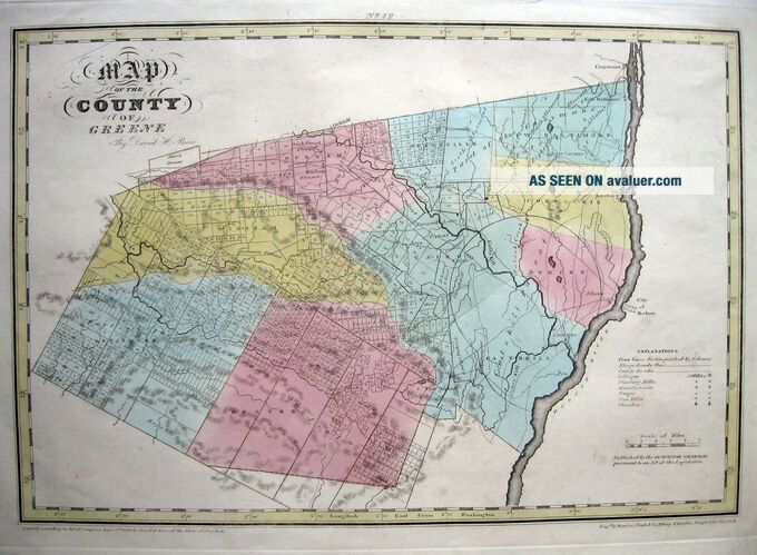
1829 GREENE COUNTY, NY Hudson Riv DAVID BURR 12½ X18½ " ORIG ANTIQUE Engraving
Item History & Price
| Reference Number: Avaluer:60062 | Type: Map |
| US State: New York | Original/Reproduction: Antique Original |
| Cartographer/Publisher: David H. Burr | Publication Year: 1829 |
| Date Range: 1800-1899 | Year: 1829 |
MAP OF THE COUNTY OF GREENE
By DAVID H. BURR (1803-1875)
Map Area: 12½ x 18½". Page size: 16 x 20¾".
An ORIGINAL 19thc. copperplate engraved map by David Burr;
from the 1829
first edition of Burr's Atlas of New York.
SCALE: 2 Inches = 5 Miles.
Very accurate and based on actual surveys,
this is one of the very first maps of the county!
Divided into tracts and named Patents.
Early roads, rivers, creeks. Catskill, Athens, New Baltimore,...r style="font-style: italic;">Coxsackie, Windham, Durham, Hunter, Lexington, Freehold,
Cairo, Greenville and more.
Good margins. Excellent old paper.
Original hand color.
This rather scarce map is clean and bright;
condition is very good.
SOLD AS SEEN - ASIS. All sales are final.
GUARANTEEDORIGINAL... NOT A REPRODUCTION!
BUY WITHCONFIDENCE ~ WE HAVE 100% positive feedback.
Flat rate shipping for US only;includes sturdy mailing tube.
International okay, with cost to be calculated.
Payment due within 2 days of purchase. MOREoriginal BURR MAPS IN OUR EBAY STORE!!
01107
By DAVID H. BURR (1803-1875)
Map Area: 12½ x 18½". Page size: 16 x 20¾".
An ORIGINAL 19thc. copperplate engraved map by David Burr;
from the 1829
first edition of Burr's Atlas of New York.
SCALE: 2 Inches = 5 Miles.
Very accurate and based on actual surveys,
this is one of the very first maps of the county!
Divided into tracts and named Patents.
Early roads, rivers, creeks. Catskill, Athens, New Baltimore,
Cairo, Greenville and more.
Good margins. Excellent old paper.
Original hand color.
This rather scarce map is clean and bright;
condition is very good.
SOLD AS SEEN - ASIS. All sales are final.
GUARANTEEDORIGINAL... NOT A REPRODUCTION!
BUY WITHCONFIDENCE ~ WE HAVE 100% positive feedback.
Flat rate shipping for US only;includes sturdy mailing tube.
International okay, with cost to be calculated.
Payment due within 2 days of purchase. MOREoriginal BURR MAPS IN OUR EBAY STORE!!
01107