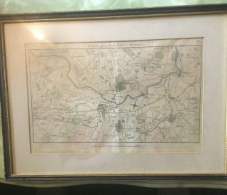
Road From London To Barwick (6), Ogilby / Bowen. E, 1736


Item History & Price

Information:
Reference Number: Avaluer:7326Format: Road Atlas/ Map
Antique/ Modern: AntiqueRegion: London, UK
Map Type: City
Original Description:
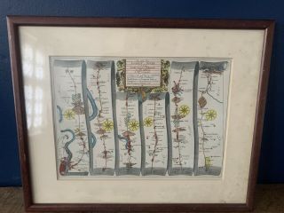
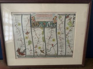
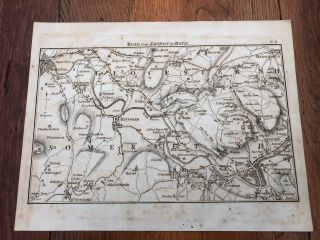
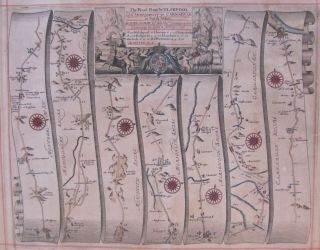
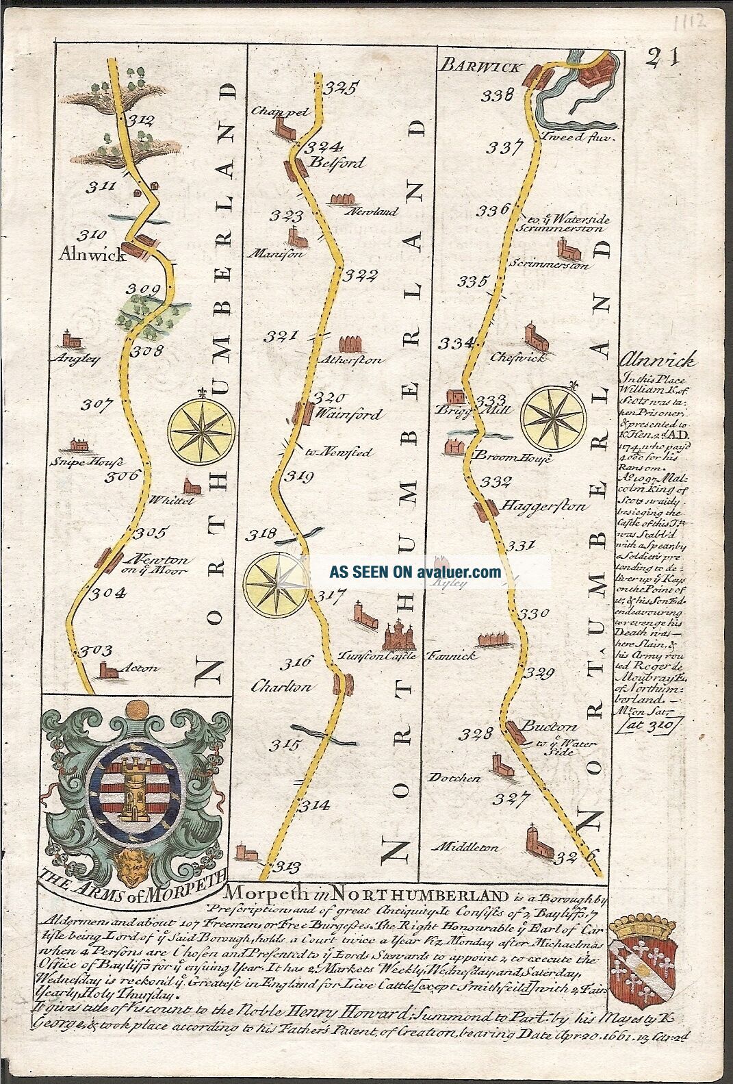
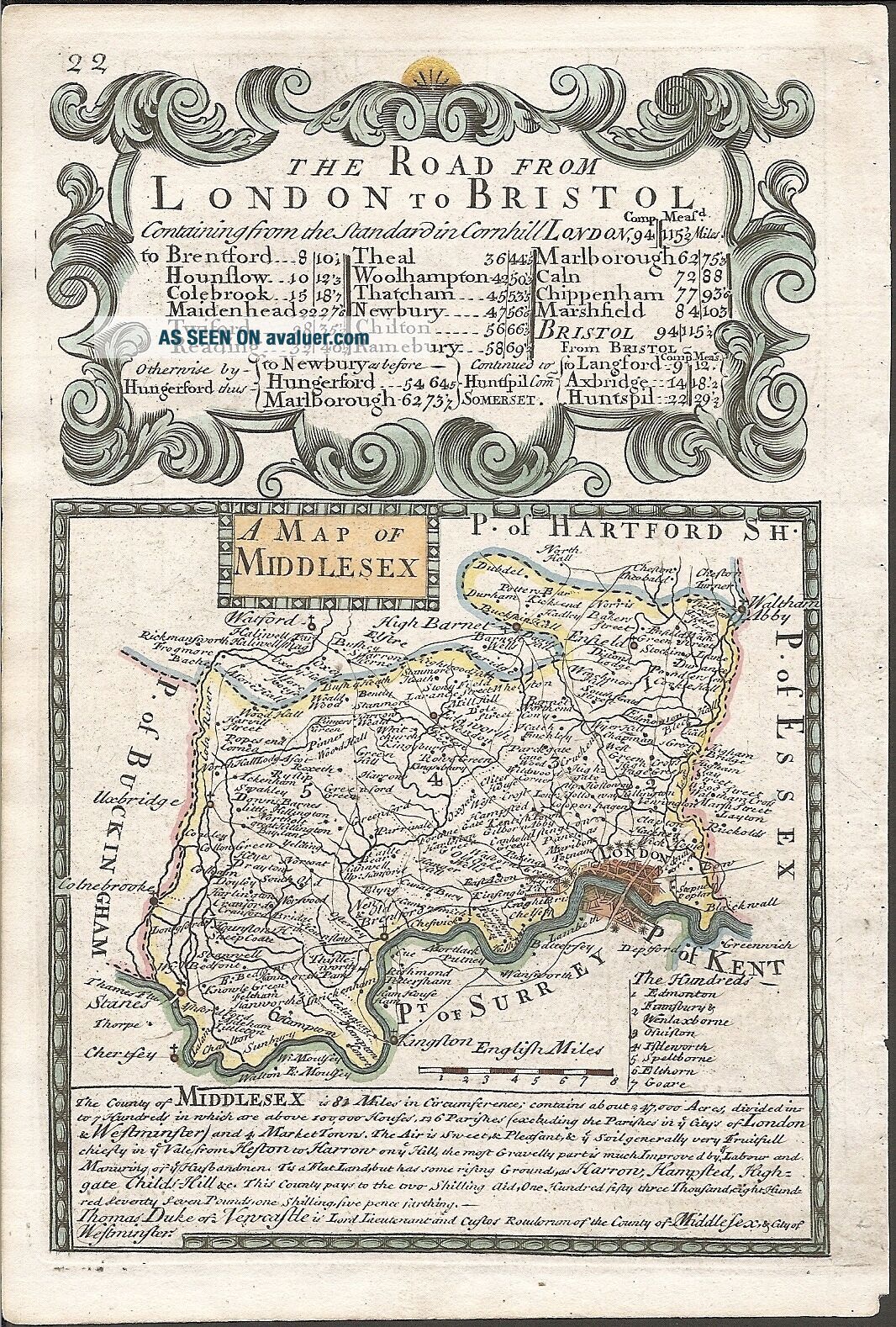
Description:FULL TITLE: A Map of MiddlesexPage 21 (continued from page 20) shows the Road from Newton on ye Moor (Newton-on-the-moor), Alnwick, Tunston Castle, Belford and Haggerston to Barwick (Berwick-upon-Tweed). The plate is embellished with the Coat of Arms of Morpeth & of the Armorial Crest of The Viscount Morpeth, as well as copious notes on places of interest along the way. The strip map shows the main road and crossroads leading to various towns along the way. The engraving de...tails the surrounding topography including churches, rivers, bridges, pastures, woods, forests and hills. On each strip is a compass rose showing the direction of travel as well as the distance, in miles, from the start point. Page 22 shows a Map of Middlesex with a description of the County, identifying the Hundreds, the size of the County in acres, the number of Houses, Parishes and Market Towns. ). Page 22 is also the title page for 'The Road from London to Bristol', the title being enclosed in an ornate cartouche. Publisher: Thomas Bowles, St. Paul’s Churchyard, LondonFull title: Britannia Depicta or Ogilby Improv’d; being a correct copy of Mr. Ogilby’s actual survey of all ye direct & principal crossroads in England and Wales: wherein are exactly delineated & engraven, all ye Cities, Towns, Villages, Churches, Seats &c. situated on or near the Roads, with their respective distances in measured and computed miles. The sheet is engraved on both sides. The engraving has distinct plate marks and good margins. The engraving has been washed & pressed by a qualified conservator and is beautifully hand coloured.
Cartographer: Ogilby / Bowen. E, Date: 1736Conditon: GGTechnique: Copper EngravingColour: ColouredWidth x Height (cms): 13.6 x 19.9Ref: JJB1112
Powered by eBay Turbo Lister


    Similar items


  • " The Road From London To Southampton " 1720 Ogilby Owen & Bowen Us

    " The Road From London To Southampton " 1720 Ogilby Owen & Bowen Us

  • John Ogilby Road From London To Dover Antique Maps Of Britain

    John Ogilby Road From London To Dover Antique Maps Of Britain

  • John Ogilby Road From London To Hith In Com Kent Antique Maps Of Britain

    John Ogilby Road From London To Hith In Com Kent Antique Maps Of Britain

  • The Road From London To Aberystwyth From 1700s

    The Road From London To Aberystwyth From 1700s

  • A Piece Of Reading History Road From London To Bath &cc No 4 Map Reading

    A Piece Of Reading History Road From London To Bath &cc No 4 Map Reading

  • Rare Wedgwood The Road From London To The City Of Bristol Britannia Mug Cup

    Rare Wedgwood The Road From London To The City Of Bristol Britannia Mug Cup

  • 1792 Topographical Map - Part Of The Great Road From London To Bath & Bristol.  11

    1792 Topographical Map - Part Of The Great Road From London To Bath & Bristol. 11

  • 17th Century,  Engraving,  The Road From Welshpool To Carnarvan,  By Ogilby.  C.  1675

    17th Century, Engraving, The Road From Welshpool To Carnarvan, By Ogilby. C. 1675


    • You might also like


    • Hungary & Romania 1579 (1584) Ortelius Unusual Antique Copper Engraved Map

      Hungary & Romania 1579 (1584) Ortelius Unusual Antique Copper Engraved Map

    • Brussels Bruxelles Belfium 1777 De Ferraris & Dupuis Large Antique Map Sheet Xxi

      Brussels Bruxelles Belfium 1777 De Ferraris & Dupuis Large Antique Map Sheet Xxi

    • 1616 Atlas Map Of Iceland.

      1616 Atlas Map Of Iceland.

    • Kazan Russia 1767 Le Clerc/lespinasse Antique Copper Engraved City View

      Kazan Russia 1767 Le Clerc/lespinasse Antique Copper Engraved City View

    • 1899 Stanford,  Folding Map Of Norwich,  Norfolk,  Arthur Collins,  Jarrold & Sons,

      1899 Stanford, Folding Map Of Norwich, Norfolk, Arthur Collins, Jarrold & Sons,

    • 1948 Vintage Linen Colour Map Geological Survey Ten Mile Of Great Britain

      1948 Vintage Linen Colour Map Geological Survey Ten Mile Of Great Britain

    • 1944 Map Flying Bombs Sussex Ww2 Newspaper Military Kent Courier German V1 V2

      1944 Map Flying Bombs Sussex Ww2 Newspaper Military Kent Courier German V1 V2

    • Dated 1638 Vellum Map Of Icklesham Sussex Showing Land Uses Owners Etc

      Dated 1638 Vellum Map Of Icklesham Sussex Showing Land Uses Owners Etc

Avaluer          About Us          Privacy Policy          Contact Us          UP
© 2022, avaluer.net, Inc. or its affiliates