Preliminary Chart Of Hudson River York Map US Coast Survey 1861
Item History & Price
| Reference Number: Avaluer:7385 | Type: River Map |
| Topic: Maps | Year: 1861 |
| Publication Year: 1861 | US State: New York |
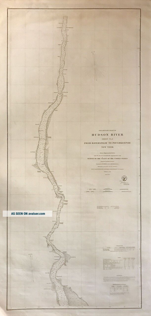
BACHE, A.D. & U.S. COAST SURVEYPreliminary Chart of Hudson River Sheet No. 2 From Haverstraw to Poughkeepsie New YorkWashington: Government Printing Office, 1861.
Sea chart. Uncolored engraving. Image measures 38.75 x 17.25".
Simple nautical chart or maritime map depicts the Hudson River from Haverstraw and Croton north as far as P...oughkeepsie as it was in 1861. Includes Peekskill, West Point, Newburgh, and several other towns along the Hudson. The chart notes depth soundings throughout to help navigate the waters. Harbors, creeks, lighthouses, and other topographical features are also noted.
This map was issued by the U.S. Coast Survey under the supervision of A. D. Bache, Superintendent. Triangulation by E. Blunt and topography by F. H. Gerdes and J. Mechan. This map is in good condition with minor foxing. Minor edge wear. Lined with original linen.
Alexander Dallas Bache (1806-1867) was an incredibly prolific surveyor, who worked as the superintendent of the United States Coast Survey, which was first established in 1807. Over the course of the 19th century, the survey worked closely with the U.S. Navy to produce sea charts of the country's waters that could serve scientific as well as military functions.
ARGOSY BOOK STOREOld & Rare Books, Maps & Prints. Since 1925
116 East 59th Street, New York, NY 10022
New York City's oldest independent book storeArgosy Book Store, founded in 1925, is now in its third generation of family ownership. Our enormous stock of antiquarian and out-of-print items fills a six-floor building in midtown Manhattan and a large warehouse in Brooklyn. We specialize in Americana, modern first editions, autographs, art, antique maps & prints, and the history of science & medicine. We also have thousands of books in all other fields of interest. We are founding members of the Antiquarian Booksellers Association of America, and we belong to the International League of Antiquarian Booksellers and the Appraisers Association of America.The Argosy Gallery, located on the second floor of the book store, has one of the most extensive collections of antique maps and prints in New York City. A small selection of our materials are available online, but these are merely a sampling of the many thousands of pre-20th century materials in our collection. Our materials cover from botanicals to maritime maps and everything in between. Whether you have something specific in mind or just want to take a look around, you're bound to find something that delights and often surprises you. If you can't make it into the gallery, please do not hesitate to contact us with any questions.Authenticity:
All items are original antiques, unless otherwise specified. Certificate of Authenticity can be provided upon request.Availability:
All items are sold on a first come first served basis. Anything sold directly through ebay is instantly removed from the database, but keep in mind that we do also sell through other online venues, and of course in our store. On rare occasions the item you want may be unavailable.Payment:
We accept Visa, Mastercard, and American Express via Paypal. We also accept payment via credit cards directly.Terms:
Prices are net, and do not include shipping charges. Sales tax will be added for all residents of New York State.Shipping:
Shipping rates not negotiable. We can consolidate shipping. All items shipped within three business day after receiving payment.
Domestic Shipping:
Shipping charges will be calculated based on buyers location.
Overseas Shipping:
All international packages sent Airmail via DHL, TNT, FED-EX, or USPS for $35.00. We will contact you for approval ONLY IF the shipping cost is greater than $35.Insurance:
All our products are insured against loss or damage. Warranty & Returns:
Items may be returned, within fourteen days of receipt, if our description was inaccurate. Please notify us before returning anything, and make sure the items are carefully packed. Refunds do not include shipping, handling or international custom charges incurred. No refunds issued for items returned in damaged condition. Returns must arrive is same condition as when item was shipped.Framing and Archival Services:
We offer fine custom framing and advise on framing challenges. We provide conservation services for all works on paper as well as conservation storage solutions. Contact us via ebay.
BEWARE!
If anyone attempts to contact you, from a different ebay account claiming to represent Argosy Books, contact us directly.