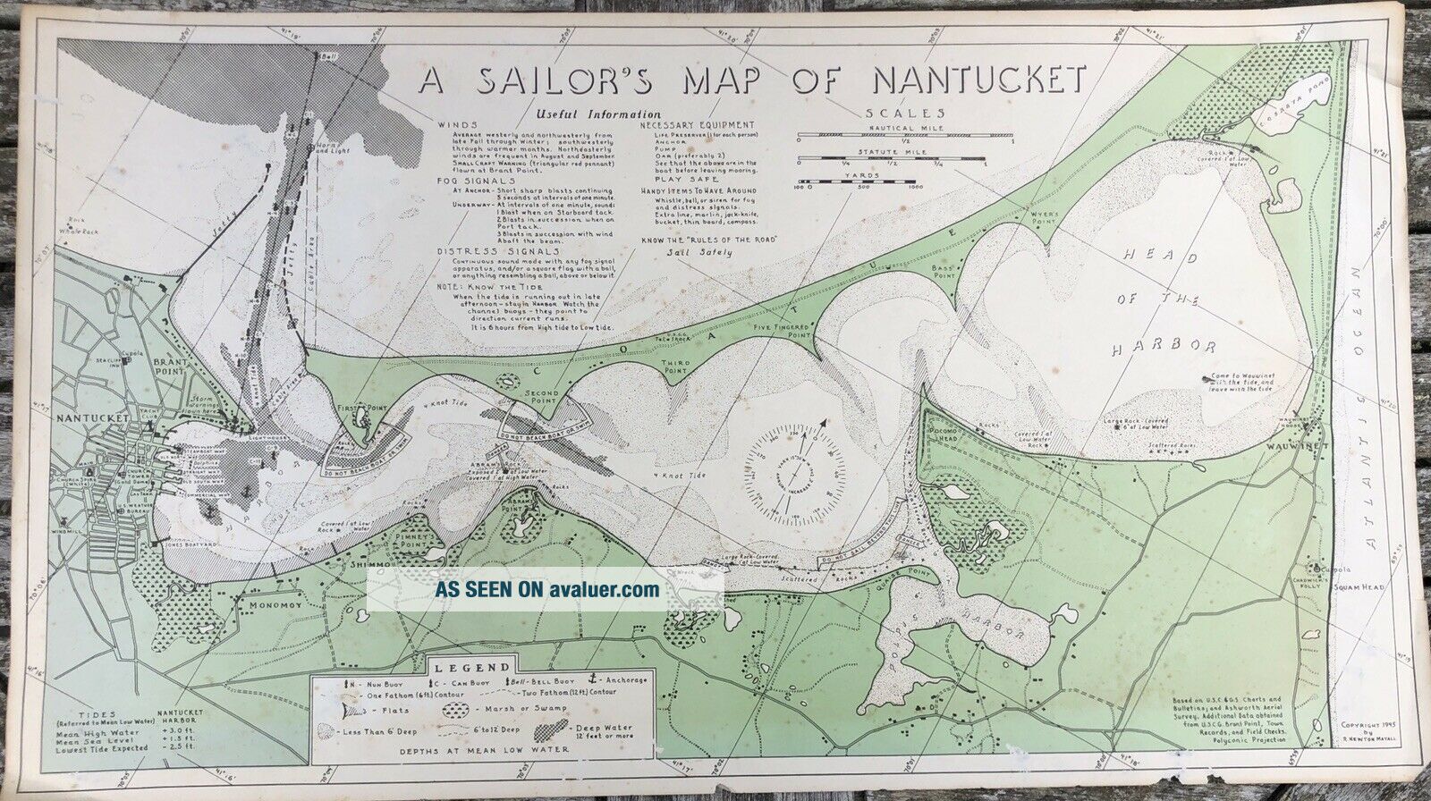
Rare 1945 A Sailor’s Map Of Nantucket By R. Newton Mayall


Item History & Price

Information:
Reference Number: Avaluer:7729Year: 1945
Original Description:
Very rare antique printed color map showing Nantucket Harbor, Polpis Harbor, and Head of the Harbor with navigational information, warnings, as well as towns, roads, notable buildings, and marsh areas. By R. Newton Mayall, 1945. Some spotting and tears around edges. Please see pictures. Approx. 12 x 21.75 inches.
If you have any questions, please ask.


    Similar items


  • 1945 A Child

    1945 A Child ' S Garden Of Verses By Robert Louis Stevenson Rand Mcnally Book

  • A Texan

    A Texan ' S Map Of U. S. A. Humurous Wall Hanging Lackland Air Force Base Rare

  • Rare 1901 A Sailor

    Rare 1901 A Sailor ' S Log : Recollections Of Forty Years Of Naval Life, Evans 1st

  • A Sailor

    A Sailor ' S Sketch Of The Sacramento Valley In 1842, By Yates, 1971, W/map Nf

  • A Texan

    A Texan ' S Map Of The United States Vintage Linen Postcard

  • A Visitor

    A Visitor ' S Map Of Florence Italy W Useful Notes For Tourists Thos Cook & Son

  • 1930 U.  S.  C & G.  S.  Map Of Nantucket Harbor,  1/10k Sc. ,  26.  75 " W X 31 " L, .

    1930 U. S. C & G. S. Map Of Nantucket Harbor, 1/10k Sc. , 26. 75 " W X 31 " L, .

  • Old 1898 Daisies From A Child

    Old 1898 Daisies From A Child ' S Garden Of Verses By Robert Louis Stevenson Rare


    • You might also like


    • 1860 Mitchell Hand Colored Map Colorado,  Nebraska & Kansas - Civil War Era

      1860 Mitchell Hand Colored Map Colorado, Nebraska & Kansas - Civil War Era

    • 18th Century French Map Of North America

      18th Century French Map Of North America

    • Las Vegas Nevada Vintage 1967 Us Geological Survey Quadrangle Map 4 Panels

      Las Vegas Nevada Vintage 1967 Us Geological Survey Quadrangle Map 4 Panels

    • Rare Antique 1845 Maps United States Exploring Expedition Book Antartica Hawaii

      Rare Antique 1845 Maps United States Exploring Expedition Book Antartica Hawaii

    • Vintage 1926 Map Hollywood From The Best Surveys Of The Time

      Vintage 1926 Map Hollywood From The Best Surveys Of The Time

    • American Continent (western Hemisphere) 1747 Bowen Antique Copper Engraved Map

      American Continent (western Hemisphere) 1747 Bowen Antique Copper Engraved Map

    • Gulf Coast Florida Texas United States 1705 De Fer Unusual Antique Engraved Map

      Gulf Coast Florida Texas United States 1705 De Fer Unusual Antique Engraved Map

    • California As Island United States 1700 De Fer Unusual First Edition Antique Map

      California As Island United States 1700 De Fer Unusual First Edition Antique Map

Avaluer          About Us          Privacy Policy          Contact Us          UP
© 2022, avaluer.net, Inc. or its affiliates