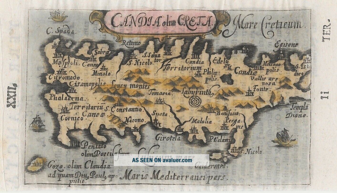
Antique Map Of Crete Greece From 1658 By Gabriel Bucelin


Item History & Price

Information:
Reference Number: Avaluer:8493Cartographer/Publisher: Gabriel Bucelin
Country/Region: Greece, CreteOriginal/Reproduction: Antique Original
Topic: AntiquesYear: 1658
Publication Year: 1658
Original Description:
DescriptionMiniature map of the island of Crete by Gabriel Bucelin. From the work Praecipuarum Universi Terrarum Orbis, published by Johannes Görlin in 1658, Ulm. The map is decorated with 3 sailing ships. The mythical labyrinth of Crete which kept the minotaur is also depicted on the map.

Title: Candia olim Creta
Date: 1658
Size: 6.7 x 10.8 cm
Verso: Text in latin
Condition: Good (G)
Condition notes: trimmed at the lower edge, not affecting the map.
Authenti...cy: An authentic antique map printed at the date stated. We do not deal in reproductions or modern copies

Shipping & return policyWe offer a no questions return/refund policy. The item just needs to be sent within 14 days of receipt, in original condition and safely packed.We ship within 2-5 business days, safely packed. If you have any questions, please feel free to contact us.

Rasmussen Antique Maps, Books & Prints
VAT-NR: 38576593


    Similar items


  • Uncommon Antique Map Of Southeast Asia From 1658 By Gabriel Bucelin

    Uncommon Antique Map Of Southeast Asia From 1658 By Gabriel Bucelin

  • Antique Map Of Sumatra Asia From 1561 By Johannes Honter

    Antique Map Of Sumatra Asia From 1561 By Johannes Honter

  • Antique Map Of China,  Korea And Japan By Rizzi Zannoni From 1790

    Antique Map Of China, Korea And Japan By Rizzi Zannoni From 1790

  • Antique View Of Quebec,  Canada From 1763 By Terreni

    Antique View Of Quebec, Canada From 1763 By Terreni

  • Antique Map Of Turkey,  Greece And The Balkans By Robert De Vaugondy 1750

    Antique Map Of Turkey, Greece And The Balkans By Robert De Vaugondy 1750

  • Antique Map Of York City From Valentines History Of Ny C1860 14 By 9

    Antique Map Of York City From Valentines History Of Ny C1860 14 By 9

  • Antique Map Of Cornwall Divided Into Hundreds By C Smith London 1804

    Antique Map Of Cornwall Divided Into Hundreds By C Smith London 1804

  • 1867 Antique Map Of Wolcott,  Connecticut,  From Beers Atlas Framed

    1867 Antique Map Of Wolcott, Connecticut, From Beers Atlas Framed


    • You might also like


    • Hungary & Romania 1579 (1584) Ortelius Unusual Antique Copper Engraved Map

      Hungary & Romania 1579 (1584) Ortelius Unusual Antique Copper Engraved Map

    • Brussels Bruxelles Belfium 1777 De Ferraris & Dupuis Large Antique Map Sheet Xxi

      Brussels Bruxelles Belfium 1777 De Ferraris & Dupuis Large Antique Map Sheet Xxi

    • 1616 Atlas Map Of Iceland.

      1616 Atlas Map Of Iceland.

    • Kazan Russia 1767 Le Clerc/lespinasse Antique Copper Engraved City View

      Kazan Russia 1767 Le Clerc/lespinasse Antique Copper Engraved City View

    • 1899 Stanford,  Folding Map Of Norwich,  Norfolk,  Arthur Collins,  Jarrold & Sons,

      1899 Stanford, Folding Map Of Norwich, Norfolk, Arthur Collins, Jarrold & Sons,

    • 1948 Vintage Linen Colour Map Geological Survey Ten Mile Of Great Britain

      1948 Vintage Linen Colour Map Geological Survey Ten Mile Of Great Britain

    • 1944 Map Flying Bombs Sussex Ww2 Newspaper Military Kent Courier German V1 V2

      1944 Map Flying Bombs Sussex Ww2 Newspaper Military Kent Courier German V1 V2

    • Dated 1638 Vellum Map Of Icklesham Sussex Showing Land Uses Owners Etc

      Dated 1638 Vellum Map Of Icklesham Sussex Showing Land Uses Owners Etc

Avaluer          About Us          Privacy Policy          Contact Us          UP
© 2022, avaluer.net, Inc. or its affiliates