1880 Hand Colored COUNTY Map TEXAS 23 " X 15 " MITCHELL GALVESTON BAY RARE

Item History & Price
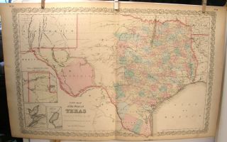
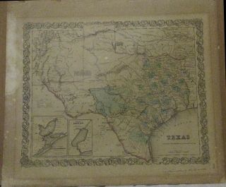
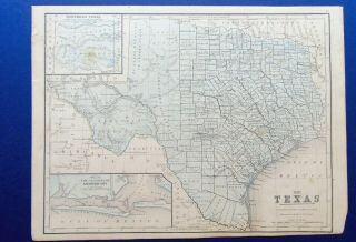
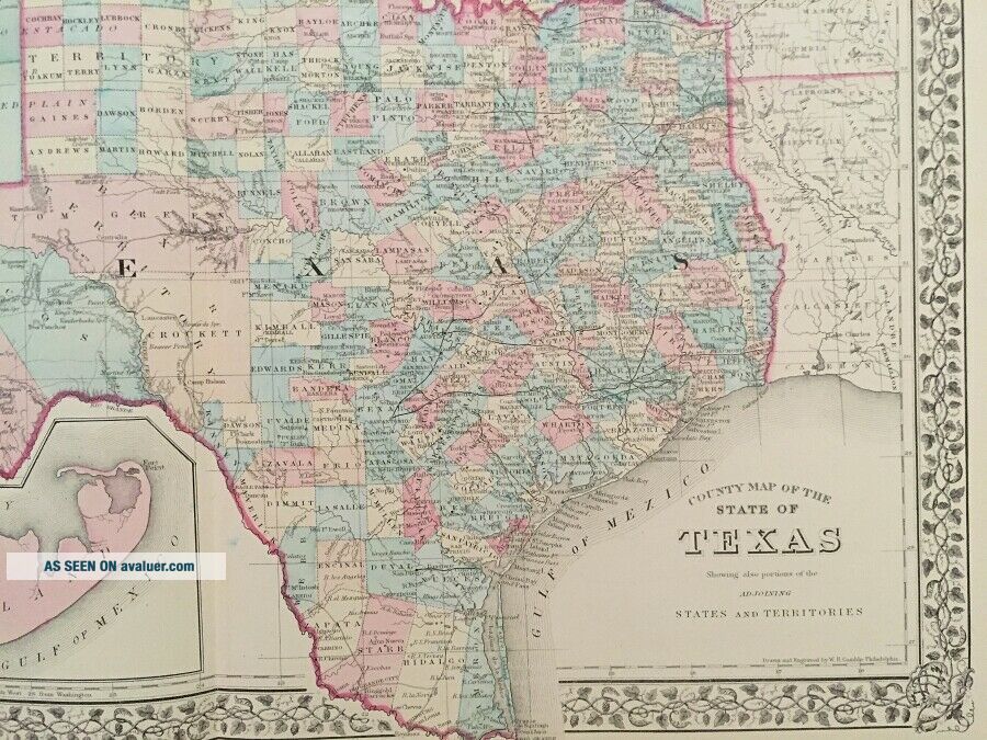
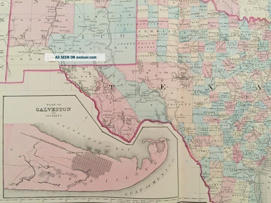
1880 Large Hand Colored County Map Of TexasMitchell - RareMap Size 23" x 15"Offered here is a wonderful hand colored county Map of Texas by Mitchell. Map measures 23" x 15" and is folded as issued.
CONDITION
General wear and browning. Creasing and a little loss to corners. Few very small tears to margin with lossSee our other itemsPAYMENTSHIPPINGRETURNSQUESTIONS?PAYMENTSHIPPINGRETURNSQUESTIONS?Please make payment within 5 days after close of the auction. W...e will escalate cases with eBay if bidders do not submit payment within the 5 day period following the auction's close.
If, for whatever reason you are unable to pay within this time, we ask that you notify us before bidding. In many cases, we will be happy to work with you within a reasonable timeframe if you notify us.USA/CANADA - All items are sent USPS First Class unless otherwise stated in the auction listing. On dispatch you will be issued with a tracking number. Higher value items (over $50) will always be fully insured at no extra cost to you. WORLDWIDE - All items are sent USPS First Class and trackable (please note that costs for postage will vary depending on your country.) Higher value items will always be fully insured and trackable at no extra cost to you. We pack all shipments with great care so that all items arrive as they left us. We also combine items so if you win more than one auction, the cost of postage will be greatly lower.Please note that we always collate and describe the items we sell to the very best of our ability. If you have questions regarding an item please get in contact so we can help you further before the auction's close.
If for whatever reason an item you have received does not match our listing we will always issue you a hassle-free full refund on return of the item which will also include any postage costs you have incurred. It is our goal to work with you to ensure that you are fully satisfied with your purchase.If you have questions regarding this item or would like to get in touch with us, please send us a message through eBay or you may contact us through our website, Regency Antique Books.1880 Hand Colored COUNTY Map TEXAS 23" x 15" MITCHELL GALVESTON BAY RARE 1880 Large Hand Colored County Map Of TexasMitchell - RareMap Size 23" x 15"Offered here is a wonderful hand colored county Map of Texas by Mitchell. Map measures 23" x 15" and is folded as issued.
CONDITION
General wear and browning. Creasing and a little loss to corners. Few very small tears to margin with lossSee our other itemsPAYMENTPlease make payment within 5 days after close of the auction. We will escalate cases with eBay if bidders do not submit payment within the 5 day period following the auction's close.
If, for whatever reason you are unable to pay within this time, we ask that you notify us before bidding. In many cases, we will be happy to work with you within a reasonable timeframe if you notify us.SHIPPINGUSA/CANADA - All items are sent USPS First Class unless otherwise stated in the auction listing. On dispatch you will be issued with a tracking number. Higher value items (over $50) will always be fully insured at no extra cost to you. WORLDWIDE - All items are sent USPS First Class and trackable (please note that costs for postage will vary depending on your country.) Higher value items will always be fully insured and trackable at no extra cost to you. We pack all shipments with great care so that all items arrive as they left us. We also combine items so if you win more than one auction, the cost of postage will be greatly lower.RETURNSPlease note that we always collate and describe the items we sell to the very best of our ability. If you have questions regarding an item please get in contact so we can help you further before the auction's close.
If for whatever reason an item you have received does not match our listing we will always issue you a hassle-free full refund on return of the item which will also include any postage costs you have incurred. It is our goal to work with you to ensure that you are fully satisfied with your purchase.QUESTIONS?If you have questions regarding this item or would like to get in touch with us, please send us a message through eBay or you may contact us through our website, Regency Antique Books.1880 Hand Colored COUNTY Map TEXAS 23" x 15" MITCHELL GALVESTON BAY RARE
CONDITION
General wear and browning. Creasing and a little loss to corners. Few very small tears to margin with lossSee our other itemsPAYMENTSHIPPINGRETURNSQUESTIONS?PAYMENTSHIPPINGRETURNSQUESTIONS?Please make payment within 5 days after close of the auction. W...e will escalate cases with eBay if bidders do not submit payment within the 5 day period following the auction's close.
If, for whatever reason you are unable to pay within this time, we ask that you notify us before bidding. In many cases, we will be happy to work with you within a reasonable timeframe if you notify us.USA/CANADA - All items are sent USPS First Class unless otherwise stated in the auction listing. On dispatch you will be issued with a tracking number. Higher value items (over $50) will always be fully insured at no extra cost to you. WORLDWIDE - All items are sent USPS First Class and trackable (please note that costs for postage will vary depending on your country.) Higher value items will always be fully insured and trackable at no extra cost to you. We pack all shipments with great care so that all items arrive as they left us. We also combine items so if you win more than one auction, the cost of postage will be greatly lower.Please note that we always collate and describe the items we sell to the very best of our ability. If you have questions regarding an item please get in contact so we can help you further before the auction's close.
If for whatever reason an item you have received does not match our listing we will always issue you a hassle-free full refund on return of the item which will also include any postage costs you have incurred. It is our goal to work with you to ensure that you are fully satisfied with your purchase.If you have questions regarding this item or would like to get in touch with us, please send us a message through eBay or you may contact us through our website, Regency Antique Books.1880 Hand Colored COUNTY Map TEXAS 23" x 15" MITCHELL GALVESTON BAY RARE 1880 Large Hand Colored County Map Of TexasMitchell - RareMap Size 23" x 15"Offered here is a wonderful hand colored county Map of Texas by Mitchell. Map measures 23" x 15" and is folded as issued.
CONDITION
General wear and browning. Creasing and a little loss to corners. Few very small tears to margin with lossSee our other itemsPAYMENTPlease make payment within 5 days after close of the auction. We will escalate cases with eBay if bidders do not submit payment within the 5 day period following the auction's close.
If, for whatever reason you are unable to pay within this time, we ask that you notify us before bidding. In many cases, we will be happy to work with you within a reasonable timeframe if you notify us.SHIPPINGUSA/CANADA - All items are sent USPS First Class unless otherwise stated in the auction listing. On dispatch you will be issued with a tracking number. Higher value items (over $50) will always be fully insured at no extra cost to you. WORLDWIDE - All items are sent USPS First Class and trackable (please note that costs for postage will vary depending on your country.) Higher value items will always be fully insured and trackable at no extra cost to you. We pack all shipments with great care so that all items arrive as they left us. We also combine items so if you win more than one auction, the cost of postage will be greatly lower.RETURNSPlease note that we always collate and describe the items we sell to the very best of our ability. If you have questions regarding an item please get in contact so we can help you further before the auction's close.
If for whatever reason an item you have received does not match our listing we will always issue you a hassle-free full refund on return of the item which will also include any postage costs you have incurred. It is our goal to work with you to ensure that you are fully satisfied with your purchase.QUESTIONS?If you have questions regarding this item or would like to get in touch with us, please send us a message through eBay or you may contact us through our website, Regency Antique Books.1880 Hand Colored COUNTY Map TEXAS 23" x 15" MITCHELL GALVESTON BAY RARE