1749 Fine Anson Map Of Petaplan, Mexico

Item History & Price
| Reference Number: Avaluer:1240054 | Cartographer/Publisher: George Anson |
| Original/Reproduction: Antique Original | Mexican State: Guerrero |
| Year: 1749 | Printing Technique: Copper Plate |
| Country/Region: Mexico |
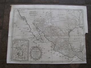
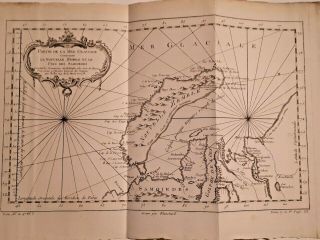
1749 Anson Map - "The Bay and Rocks of Petaplan"
Commodore George Anson made his celebrated voyage around South America and on around the world from 1740-1744 during which time he charted some of the the coast of South and Central America. This detailed plan of the ...Bay of Petaplan on the Pacific Coast of Mexico is an example of his fine work. The map shows the bay, a salt lagoon, a series of rocks called White Friars and soundings.
There is a decorative compass rose and a distance scale. The words "sample" are digitally imposed and not part of the map.
The map is in excellent condition, is hand colored and has three folds as issued.
Measurements: 490 mm X 230 mm (19.5 X 9.0 inches) with wide margins.
This is a genuine antique map and is guaranteed to be over 250 years old.
SHIPPING
United States: Regular airmail US$5.00. Tracked airmail (optional) is an additional US$12.00 for a total of US$17.00
Canada: US$3.00 for regular mail, US$9.00 for registered mail.
Rest of the World: Regular airmail US$8.00. Registered/insured airmail (optional) is an additional US$15.00 for a total of US$23.00.