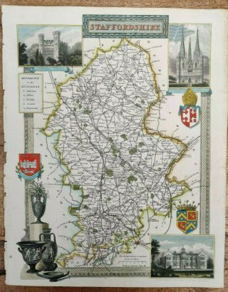
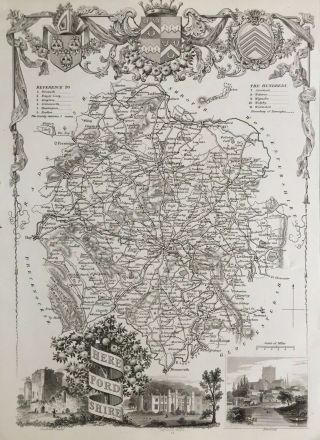
Antique Map Of Derbyshire Thomas Moule. 1836 - 48. Barclay ' S


Item History & Price

Information:
Reference Number: Avaluer:14285971County: Nottinghamshire
Era: 1700sType: County Map
Original Description:
Original Antique map of Derbyshire  Thomas Moule. 1836-48. From Barclay's English Dictionary.

Hand coloured. Lovely, detailed map.
Worth around £85.

Very good condition.

Measures 21.5 x 27.5 cm
Please see photos.
Any questions, please ask.
Thanks for looking!


    Similar items


  • Antique Map Of Staffordshire Thomas Moule 1836 - 48 Hand Coloured England

    Antique Map Of Staffordshire Thomas Moule 1836 - 48 Hand Coloured England

  • Antique Map Of Dorsetshire Thomas Moule I Dower C1850.  Old Dorset Shaftesbury.

    Antique Map Of Dorsetshire Thomas Moule I Dower C1850. Old Dorset Shaftesbury.

  • 1840

    1840 ' S Antique Framed Map Of Wiltshire - Thomas Moule - Stonehenge Etc

  • Antique Map Of Italy.  Thomas Bowen Middleton

    Antique Map Of Italy. Thomas Bowen Middleton ' S C1778. Sardinia. Sicily. Rome.

  • Antique Map Of Virginia,  Thomas & Andrews,  Boston

    Antique Map Of Virginia, Thomas & Andrews, Boston

  • 1770 Antique Map Of Wiltshire - Thomas Kitchin - Hand Coloured & Framed

    1770 Antique Map Of Wiltshire - Thomas Kitchin - Hand Coloured & Framed

  • Antique Map Of Somersetshire Thomas Bowen C 1790

    Antique Map Of Somersetshire Thomas Bowen C 1790

  • 1841 Antique Map; Herefordshire By Thomas Moule

    1841 Antique Map; Herefordshire By Thomas Moule


    • You might also like


    • Hungary & Romania 1579 (1584) Ortelius Unusual Antique Copper Engraved Map

      Hungary & Romania 1579 (1584) Ortelius Unusual Antique Copper Engraved Map

    • Brussels Bruxelles Belfium 1777 De Ferraris & Dupuis Large Antique Map Sheet Xxi

      Brussels Bruxelles Belfium 1777 De Ferraris & Dupuis Large Antique Map Sheet Xxi

    • 1616 Atlas Map Of Iceland.

      1616 Atlas Map Of Iceland.

    • Kazan Russia 1767 Le Clerc/lespinasse Antique Copper Engraved City View

      Kazan Russia 1767 Le Clerc/lespinasse Antique Copper Engraved City View

    • 1899 Stanford,  Folding Map Of Norwich,  Norfolk,  Arthur Collins,  Jarrold & Sons,

      1899 Stanford, Folding Map Of Norwich, Norfolk, Arthur Collins, Jarrold & Sons,

    • 1948 Vintage Linen Colour Map Geological Survey Ten Mile Of Great Britain

      1948 Vintage Linen Colour Map Geological Survey Ten Mile Of Great Britain

    • 1944 Map Flying Bombs Sussex Ww2 Newspaper Military Kent Courier German V1 V2

      1944 Map Flying Bombs Sussex Ww2 Newspaper Military Kent Courier German V1 V2

    • Dated 1638 Vellum Map Of Icklesham Sussex Showing Land Uses Owners Etc

      Dated 1638 Vellum Map Of Icklesham Sussex Showing Land Uses Owners Etc

Avaluer          About Us          Privacy Policy          Contact Us          UP
© 2022, avaluer.net, Inc. or its affiliates