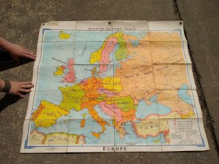
ANTIQUE 1928 CANVAS BACKED FOLDING MAP - INDUSTRIAL MAP OF EUROPE - REYAHT CO.


Item History & Price

Information:
Reference Number: Avaluer:15684718Format: Folding Map
Publication Year: 1928Topic: Maps
Features: AntiqueYear: 1928
Original/Reproduction: Antique Original
Original Description:
For sale is this antique folding map of Europe.
The map is made of canvas and is in great condition for its age.
It measures 41 3/4" x 49".
Shipping is $10 including delivery confirmation.
Please email me with any questions before bidding and THANKS FOR LOOKING!!!


    Similar items


  • Antique 1928 Canvas Backed Folding Map - Industrial Map Of United States Thayers

    Antique 1928 Canvas Backed Folding Map - Industrial Map Of United States Thayers

  • Large Denoyer - Geppert Canvas Backed Folding Map Of Europe 1967.

    Large Denoyer - Geppert Canvas Backed Folding Map Of Europe 1967.

  • Antique 1900 Linen - Backed Folding Map Of All Of The Railways In Ohio,  Hardcover

    Antique 1900 Linen - Backed Folding Map Of All Of The Railways In Ohio, Hardcover

  • Walker

    Walker ' S Gloucestershire 1845 Victorian Canvas Backed Folding Map

  • 1823 England & Wales Linen Backed Folding Map By W.  R.  Gardner 76 Cm X 64 Cm

    1823 England & Wales Linen Backed Folding Map By W. R. Gardner 76 Cm X 64 Cm

  • Vintage Cram

    Vintage Cram ' S Cloth - Back Folding Map Of Africa Superior Series

  • George F Cram

    George F Cram ' S Vintage Cloth - Back Folding Map Of Kansas

  • Vintage Cram

    Vintage Cram ' S Cloth - Back Folding Map Of Asia Superior Series


    • You might also like


    • Hungary & Romania 1579 (1584) Ortelius Unusual Antique Copper Engraved Map

      Hungary & Romania 1579 (1584) Ortelius Unusual Antique Copper Engraved Map

    • Brussels Bruxelles Belfium 1777 De Ferraris & Dupuis Large Antique Map Sheet Xxi

      Brussels Bruxelles Belfium 1777 De Ferraris & Dupuis Large Antique Map Sheet Xxi

    • 1616 Atlas Map Of Iceland.

      1616 Atlas Map Of Iceland.

    • Kazan Russia 1767 Le Clerc/lespinasse Antique Copper Engraved City View

      Kazan Russia 1767 Le Clerc/lespinasse Antique Copper Engraved City View

    • 1899 Stanford,  Folding Map Of Norwich,  Norfolk,  Arthur Collins,  Jarrold & Sons,

      1899 Stanford, Folding Map Of Norwich, Norfolk, Arthur Collins, Jarrold & Sons,

    • 1948 Vintage Linen Colour Map Geological Survey Ten Mile Of Great Britain

      1948 Vintage Linen Colour Map Geological Survey Ten Mile Of Great Britain

    • 1944 Map Flying Bombs Sussex Ww2 Newspaper Military Kent Courier German V1 V2

      1944 Map Flying Bombs Sussex Ww2 Newspaper Military Kent Courier German V1 V2

    • Dated 1638 Vellum Map Of Icklesham Sussex Showing Land Uses Owners Etc

      Dated 1638 Vellum Map Of Icklesham Sussex Showing Land Uses Owners Etc

Avaluer          About Us          Privacy Policy          Contact Us          UP
© 2022, avaluer.net, Inc. or its affiliates