1857 U. S. Coast Survey Map Of Eastern Long Island (Hamptons, Amagansett)

Item History & Price
| Reference Number: Avaluer:18754696 |
1857 U.S. Coast Survey Map of Eastern Long Island (Hamptons, Amagansett)
WE SELL ONLY ORIGINAL ANTIQUE MAPS - NOT REPRODUCTIONS
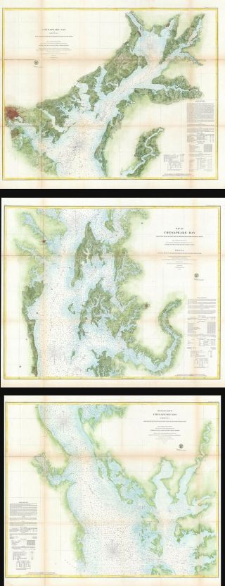
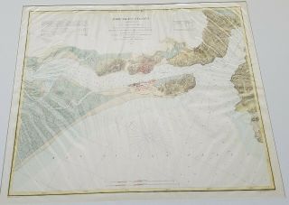
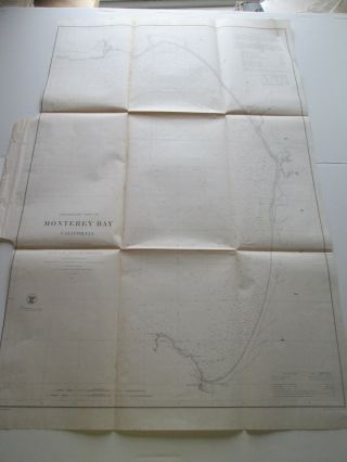
Title: Middle Part of the Southern Coast of Long Island.
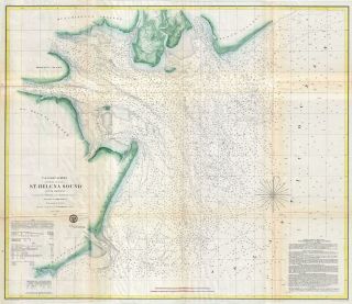
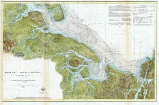
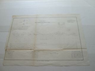
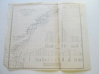
Description: This is an extraordinary and extremely rare large format 1857 U.S. Coast Survey nautical chart or maritime map of southeastern Long Island, New York. The map depicts part of Suffolk County from Moriches Bay to Napeague Harbor, including the summer getaways of Sag... Harbor, East Hampton, Southampton (South Hampton), Quogue, Bridgehampton and Amagansett, among others. It extends as far north as Gardiner's Island and Hog Neck. The inland regions are depicted in considerable detail, down to individual buildings. In addition to inland details, this chart contains a wealth of practical information for the mariner including depth soundings, harbors, and navigation tips on important channels. Two views decorate the bottom of the map, one depicting about 9 miles of coast south of Speonk, and another depicting the coast south of Shinnecock.
This map was created under the direction of A. D. Bache, Superintendent of the Survey of the Coast of the United States and one of the most influential American cartographers of the 19th century. This is one of the best maps of Long Island to appear in the 19th century.
Size: Printed area measures 25 inches high by 35 inches wide.
Condition: Very good. Some wear and toning along original fold lines. Backed on archival tissue for stability. Blank on verso.
Shipping: Shipping rates are not negotiable. Items are shipped within three business days of receiving payment. We are happy to consolidate shipping where possible. The following shipping options are available: 1. FedEx Overnight (45 USD). USA Only. Signature Required.
2. FedEx Ground or Home Delivery (15 USD). USA Only. 1 - 10 days. If your address is a P.O. Box and cannot ship FedEx we will ship USPS Priority and, while we ship promptly, recent postal personnel cutbacks mean that delivery may take time. Signature Required.
3. FedEx International or DHL International EXPRESS (45 USD).
4. We can use your FedEx Account.
Customs: International buyers are responsible for paying duty and taxes on delivery. DHL or FedEx will contact the buyer by telephone to arrange tax payment if it is levied. Duty varies by country and we cannot predict the amount you will be charged. Some countries are duty free, others are not. Typically, a customs duty and/or VAT tax will be assessed on all parcels to continental Europe. Sometimes duty or tax is due in China, but is seems very random. Hong Kong, Singapore, Korea, and Taiwan have never assessed duty on a map we shipped. Maps shipped to the UK should be duty free as educational materials, but from time to time duty of 5% is assessed incorrectly by the UK customs agents.
Insurance: All shipments are insured privately against loss and damage. All of our shipments require a signature for insurance purposes.
If you have any questions please feel free to email us through eBay.
Other ServicesConservation Framing: Geographicus recommends basic conservation framing services for any antique paper. We do not offer this service.
Antique Map Restoration: Geographicus can repair and restore your antique map. Services include deacidification cleaning flattening and backing.
BEWARE anyone attempting to contact you, from a different eBay account, claiming to represent Geographicus Antique Maps. My eBay handle is GeographicusMaps. If you are contacted by email by someone offering you my items, please call me directly to be certain you are not dealing with a con artist. "