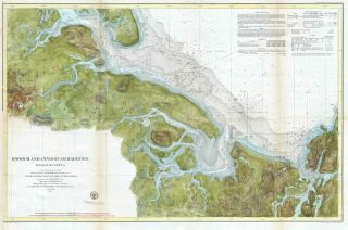
1857 U. S. Coast Survey Map Of Mare Island Strait, San Francisco Bay, California


Item History & Price

Information:
Reference Number: Avaluer:23760090Year: 1857
City: San FranciscoUS State: California
Original Description:
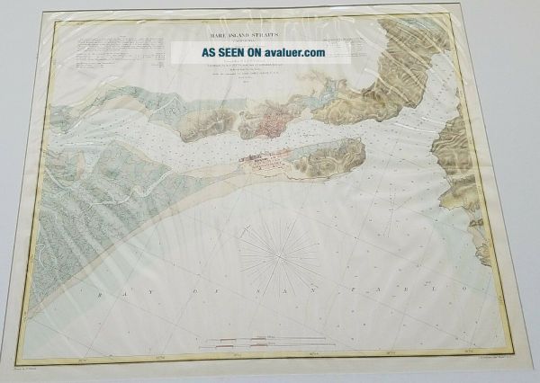
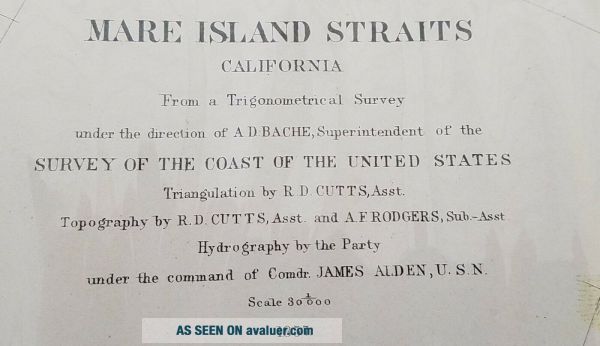
This is a lovely hand colored example of the 1857 U.S. Coast Survey nautical chart or maritime map of the Napa River and the Mare Island Straits, California. The map covers part of the San Francisco Bay area including Mare Island, Straits of Karquines and parts of Vallejo. Vallejo served as the capital of the state of California in 1852 and 1853. The chart includes numerous depth soundings along with coast features as well as notes important to the mariner. This chart was compiled unde...r the direction of A. D. Bache, Superintendent of the Survey of the Coast of the United States and one of the most influential American cartographers of the 19th century
Feel free to contact us with any questions you may have. Thanks for looking!


    Similar items


  • 1857 U.  S.  Coast Survey Map Of The Chesapeake Bay (3 Parts)

    1857 U. S. Coast Survey Map Of The Chesapeake Bay (3 Parts)

  • 1857 U.  S.  Coast Survey Map Of Eastern Long Island (hamptons,  Amagansett)

    1857 U. S. Coast Survey Map Of Eastern Long Island (hamptons, Amagansett)

  • 1857 U.  S.  Coast Survey Map Or Chart Of St.  Helena Sound,  South Carolina

    1857 U. S. Coast Survey Map Or Chart Of St. Helena Sound, South Carolina

  • 1857 U.  S.  Coast Survey Map Of Ipswich And Annisquam,  Massachusetts

    1857 U. S. Coast Survey Map Of Ipswich And Annisquam, Massachusetts

  • (1) 1857 U.  S.  Coast Survey Chart: " Monteray Bay,  California "

    (1) 1857 U. S. Coast Survey Chart: " Monteray Bay, California "

  • (1) 1857 U.  S.  Coast Survey Chart: " Measurement Of Epping Base,  Maine "

    (1) 1857 U. S. Coast Survey Chart: " Measurement Of Epping Base, Maine "

  • (1) 1857 U.  S.  Coast Survey Chart: " Aproximate Cotidal Lines "

    (1) 1857 U. S. Coast Survey Chart: " Aproximate Cotidal Lines "


    • You might also like


    • 1860 Mitchell Hand Colored Map Colorado,  Nebraska & Kansas - Civil War Era

      1860 Mitchell Hand Colored Map Colorado, Nebraska & Kansas - Civil War Era

    • 18th Century French Map Of North America

      18th Century French Map Of North America

    • Las Vegas Nevada Vintage 1967 Us Geological Survey Quadrangle Map 4 Panels

      Las Vegas Nevada Vintage 1967 Us Geological Survey Quadrangle Map 4 Panels

    • Rare Antique 1845 Maps United States Exploring Expedition Book Antartica Hawaii

      Rare Antique 1845 Maps United States Exploring Expedition Book Antartica Hawaii

    • Vintage 1926 Map Hollywood From The Best Surveys Of The Time

      Vintage 1926 Map Hollywood From The Best Surveys Of The Time

    • American Continent (western Hemisphere) 1747 Bowen Antique Copper Engraved Map

      American Continent (western Hemisphere) 1747 Bowen Antique Copper Engraved Map

    • Gulf Coast Florida Texas United States 1705 De Fer Unusual Antique Engraved Map

      Gulf Coast Florida Texas United States 1705 De Fer Unusual Antique Engraved Map

    • California As Island United States 1700 De Fer Unusual First Edition Antique Map

      California As Island United States 1700 De Fer Unusual First Edition Antique Map

Avaluer          About Us          Privacy Policy          Contact Us          UP
© 2022, avaluer.net, Inc. or its affiliates