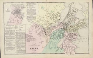
1907 Map City Of Salem Mass, MA Harbor, Neck, Massachusetts, Old, Vintage


Item History & Price

Information:
Reference Number: Avaluer:23755747Original/Reproduction: Original
Year: 1907US State: Mass
Type: MapCity: Salem
Original Description:
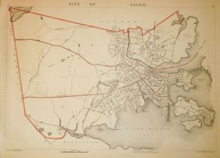
Original 1907 Map from the Massachusetts Atlas by Geo. H. Walker Publisher.

This is not a reproduction.The map shows the City of Salem.
It features: Salem Neck, Beverly Harbor, Collins cove, Mill Pond, North River, and Forest River.
The map shows rivers, lakes, roads and major sites.The map measures 19 1/2"x 28" and is in very good condition with no rips or tears.
It has a center fold from the Atlas.Please see other maps in our Ebay stor...e.

Email with any questions or requests for other maps.


    Similar items


  • 1891 Map City Of Lowell Mass Ma Atlas Plate Massachusetts

    1891 Map City Of Lowell Mass Ma Atlas Plate Massachusetts

  • 1891 Map City Of Fitchburg Mass,  Ma Old Nashua River

    1891 Map City Of Fitchburg Mass, Ma Old Nashua River

  • 1891 Map City Of Salem Winter Island Salem Neck Kernwood Mass Ma Old

    1891 Map City Of Salem Winter Island Salem Neck Kernwood Mass Ma Old

  • 1907 Map City Of Northampton & Florence,  Mill River,  Mass,  Ma,  Old Vintage

    1907 Map City Of Northampton & Florence, Mill River, Mass, Ma, Old Vintage

  • 1907 Map City Of Melrose,  Ell Pond,  Highland,  Mass,  Ma,  Massachusetts,  Old

    1907 Map City Of Melrose, Ell Pond, Highland, Mass, Ma, Massachusetts, Old

  • 1891 Map City Of Bedford Mass Old Nr Vintage Ma Massachusetts

    1891 Map City Of Bedford Mass Old Nr Vintage Ma Massachusetts

  • Antique Map City Of Salem,  Ma - Dg Beers Atlas Of Essex County 1872

    Antique Map City Of Salem, Ma - Dg Beers Atlas Of Essex County 1872

  • 1891 Map Of The City Of Marlborough Mass Ma Marlboro Old Vintage

    1891 Map Of The City Of Marlborough Mass Ma Marlboro Old Vintage


    • You might also like


    • 1860 Mitchell Hand Colored Map Colorado,  Nebraska & Kansas - Civil War Era

      1860 Mitchell Hand Colored Map Colorado, Nebraska & Kansas - Civil War Era

    • 18th Century French Map Of North America

      18th Century French Map Of North America

    • Las Vegas Nevada Vintage 1967 Us Geological Survey Quadrangle Map 4 Panels

      Las Vegas Nevada Vintage 1967 Us Geological Survey Quadrangle Map 4 Panels

    • Rare Antique 1845 Maps United States Exploring Expedition Book Antartica Hawaii

      Rare Antique 1845 Maps United States Exploring Expedition Book Antartica Hawaii

    • Vintage 1926 Map Hollywood From The Best Surveys Of The Time

      Vintage 1926 Map Hollywood From The Best Surveys Of The Time

    • American Continent (western Hemisphere) 1747 Bowen Antique Copper Engraved Map

      American Continent (western Hemisphere) 1747 Bowen Antique Copper Engraved Map

    • Gulf Coast Florida Texas United States 1705 De Fer Unusual Antique Engraved Map

      Gulf Coast Florida Texas United States 1705 De Fer Unusual Antique Engraved Map

    • California As Island United States 1700 De Fer Unusual First Edition Antique Map

      California As Island United States 1700 De Fer Unusual First Edition Antique Map

Avaluer          About Us          Privacy Policy          Contact Us          UP
© 2022, avaluer.net, Inc. or its affiliates