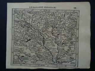
Dunn 1774 Atlas Map Hungary Romania Serbia Bulgaria Bosnia Croatia


Item History & Price

Information:
Reference Number: Avaluer:23756714Country/Region: Bosnia and Herzegovina, Croatia, Hungary, Moldova, Romania
Printing Technique: Copper PlateDate Range: 1700-1799
Type: Political MapEra: 1700s
Year: 1774Format: Atlas Map
Cartographer/Publisher: Samuel DunnOriginal/Reproduction: Antique Original
City: Bucharest
Original Description:
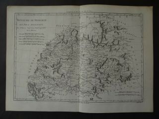
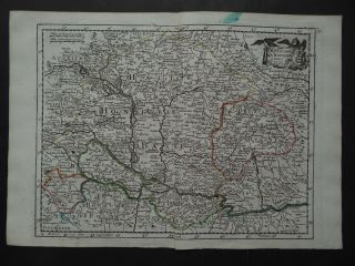
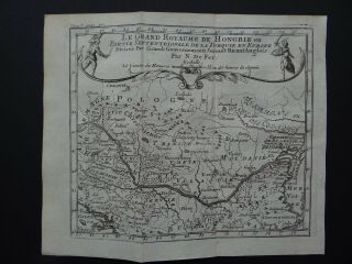
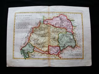
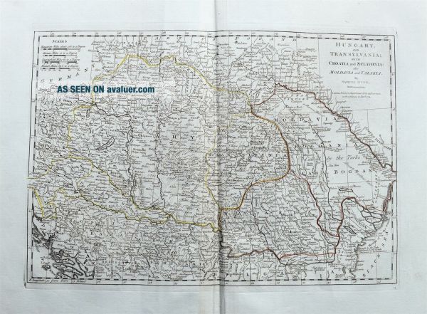
This auction is for the original antique map:" Hungary and Transylvania; with Croatia and Sclavonia also Moldavia and Valakia. "Samuel Dunn, London 1774Overview & Area: Detailed 18th century map!Shows South East Europe. Extending from Vienna until Varna and from Split until Bender in Moldova. With (parts of) Romania, Hungary, Bosnia, Serbia, Croatia, Bulgaria, Poland, ...Filled with town names, rivers, hills, lakes, etc.Also passes over the mountains shown.Old outline hand coloring.Th...is is a guaranteed original antique map!=> An early antique map - around 246 years old!Other examples of this map are offered online for up to £ 200.-Size: printed area approx. 312 x 455 mm § Decorative engraved map from 1774 §


    Similar items


  • Antique Map: Turkey,  Romania,  Serbia,  Montenegro & Bulgaria,  C 1880,  Colour

    Antique Map: Turkey, Romania, Serbia, Montenegro & Bulgaria, C 1880, Colour

  • Vaugondy Decorative Map Hungary Romania Bulgaria - 1786

    Vaugondy Decorative Map Hungary Romania Bulgaria - 1786

  • 1895 Victorian Map Basin Of Danube Hungary Romania Bosnia Bulgaria Vienna

    1895 Victorian Map Basin Of Danube Hungary Romania Bosnia Bulgaria Vienna

  • 1608 Hondius Mercator Atlas Map Hungary - Hungaria - Le Royaume D

    1608 Hondius Mercator Atlas Map Hungary - Hungaria - Le Royaume D ' Hongrie

  • 1787 Bonne Desmarest Atlas Map Hungary - Royaume De Hongrie

    1787 Bonne Desmarest Atlas Map Hungary - Royaume De Hongrie

  • 1743 Le Rouge Atlas Map Hungary - Le Royaume De Hongrie

    1743 Le Rouge Atlas Map Hungary - Le Royaume De Hongrie

  • 1721 De Fer Atlas Map Hungary - Grand Royaume De Hongrie Ou Turquie En Europe

    1721 De Fer Atlas Map Hungary - Grand Royaume De Hongrie Ou Turquie En Europe

  • 1789 Bonne - Rare Map: Hungary,  Romania,  Transylvania,  Slavonia Croatia Budapest

    1789 Bonne - Rare Map: Hungary, Romania, Transylvania, Slavonia Croatia Budapest


    • You might also like


    • Hungary & Romania 1579 (1584) Ortelius Unusual Antique Copper Engraved Map

      Hungary & Romania 1579 (1584) Ortelius Unusual Antique Copper Engraved Map

    • Brussels Bruxelles Belfium 1777 De Ferraris & Dupuis Large Antique Map Sheet Xxi

      Brussels Bruxelles Belfium 1777 De Ferraris & Dupuis Large Antique Map Sheet Xxi

    • 1616 Atlas Map Of Iceland.

      1616 Atlas Map Of Iceland.

    • Kazan Russia 1767 Le Clerc/lespinasse Antique Copper Engraved City View

      Kazan Russia 1767 Le Clerc/lespinasse Antique Copper Engraved City View

    • 1899 Stanford,  Folding Map Of Norwich,  Norfolk,  Arthur Collins,  Jarrold & Sons,

      1899 Stanford, Folding Map Of Norwich, Norfolk, Arthur Collins, Jarrold & Sons,

    • 1948 Vintage Linen Colour Map Geological Survey Ten Mile Of Great Britain

      1948 Vintage Linen Colour Map Geological Survey Ten Mile Of Great Britain

    • 1944 Map Flying Bombs Sussex Ww2 Newspaper Military Kent Courier German V1 V2

      1944 Map Flying Bombs Sussex Ww2 Newspaper Military Kent Courier German V1 V2

    • Dated 1638 Vellum Map Of Icklesham Sussex Showing Land Uses Owners Etc

      Dated 1638 Vellum Map Of Icklesham Sussex Showing Land Uses Owners Etc

Avaluer          About Us          Privacy Policy          Contact Us          UP
© 2022, avaluer.net, Inc. or its affiliates