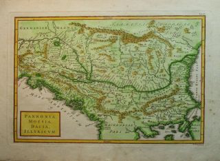
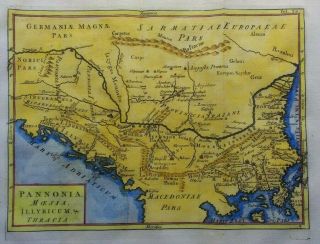
Antique Map, PANNONIA & ILLYRIA, BALKANS REGION, A. M. Mallet, C. 1719


Item History & Price

Information:
Reference Number: Avaluer:23762516Cartographer/Publisher: Alain Manesson Mallet
Year: 1719Printing Technique: Copper Plate
Date Range: 1700-1799Original/Reproduction: Antique Original
Country/Region: Balkans, Bosnia and Herzegovina, Croatia, SerbiaFormat: Atlas Map
Era: 1700sType: Atlas map
Original Description:
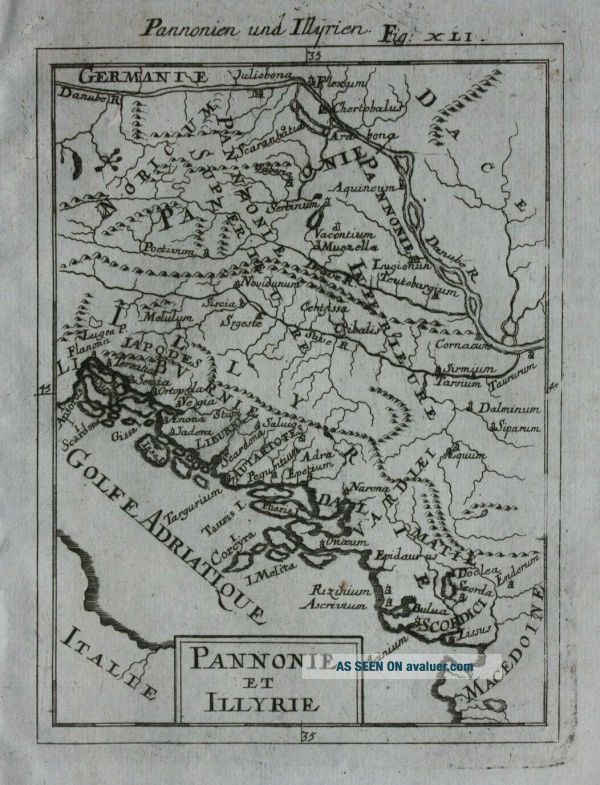
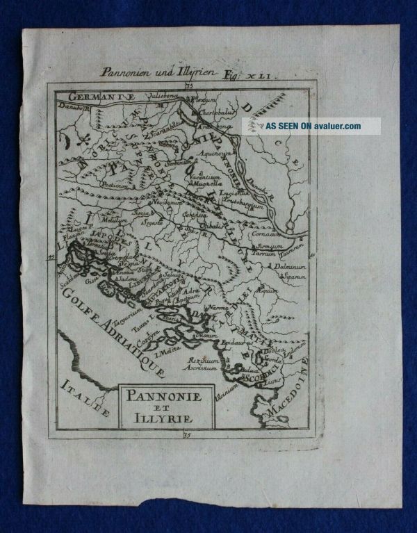
Title / Subject: 'Pannonie et Illyrie' / Adriatic Sea and the Balkans
Date: c.1719
Size: 112mm x 140mm (printed area only, map is 112mm x 72mm), margins beyond, blank verso.
Description: An original antique, copper-plate engraved map of ancient Pannonia and Illyria. It is printed on hand-laid paper and uncoloured as published.
Cartographer / Engraver: Alain Manesson Mallet
Provenance: German edition of Mallet's 'Description de l'Univers', published in Frankfurt, c.1719...r>Condition: Very good condition. Light age toning / handling marks. Slightly uneven bottom edge of the sheet. Uncoloured as published. Please study the photographs carefully to fully appreciate the condition.
Ref: #04408


    Similar items


  • Antique Map Of Turkey Balkan Bulgaria Romania Servia Montenegro 1903

    Antique Map Of Turkey Balkan Bulgaria Romania Servia Montenegro 1903

  • Antique Map Of The Balkans By Christoph Cellarius 1789

    Antique Map Of The Balkans By Christoph Cellarius 1789

  • 1898 Antique Map Of The Balkan Peninsula Old Europe 19th Century Victorian

    1898 Antique Map Of The Balkan Peninsula Old Europe 19th Century Victorian

  • Antique Map Plan The Balkan Peninsula 1895 120,  Years Old (large)

    Antique Map Plan The Balkan Peninsula 1895 120, Years Old (large)

  • Antique Map: Pannonia,  Dacia / Roman Empire By A K Johnston,  Classical Map,  1880

    Antique Map: Pannonia, Dacia / Roman Empire By A K Johnston, Classical Map, 1880

  • 1888 Antique Map Of The Balkans The Balkan Peninsula French 19th Century

    1888 Antique Map Of The Balkans The Balkan Peninsula French 19th Century

  • Antique Map Of The Balkans And Greece By Christoph Cellarius 1764

    Antique Map Of The Balkans And Greece By Christoph Cellarius 1764

  • 1907 Antique Map Of The Balkans Greece Cyprus Bulgaria Serbia Bosnia Macedonia

    1907 Antique Map Of The Balkans Greece Cyprus Bulgaria Serbia Bosnia Macedonia


    • You might also like


    • Hungary & Romania 1579 (1584) Ortelius Unusual Antique Copper Engraved Map

      Hungary & Romania 1579 (1584) Ortelius Unusual Antique Copper Engraved Map

    • Brussels Bruxelles Belfium 1777 De Ferraris & Dupuis Large Antique Map Sheet Xxi

      Brussels Bruxelles Belfium 1777 De Ferraris & Dupuis Large Antique Map Sheet Xxi

    • 1616 Atlas Map Of Iceland.

      1616 Atlas Map Of Iceland.

    • Kazan Russia 1767 Le Clerc/lespinasse Antique Copper Engraved City View

      Kazan Russia 1767 Le Clerc/lespinasse Antique Copper Engraved City View

    • 1899 Stanford,  Folding Map Of Norwich,  Norfolk,  Arthur Collins,  Jarrold & Sons,

      1899 Stanford, Folding Map Of Norwich, Norfolk, Arthur Collins, Jarrold & Sons,

    • 1948 Vintage Linen Colour Map Geological Survey Ten Mile Of Great Britain

      1948 Vintage Linen Colour Map Geological Survey Ten Mile Of Great Britain

    • 1944 Map Flying Bombs Sussex Ww2 Newspaper Military Kent Courier German V1 V2

      1944 Map Flying Bombs Sussex Ww2 Newspaper Military Kent Courier German V1 V2

    • Dated 1638 Vellum Map Of Icklesham Sussex Showing Land Uses Owners Etc

      Dated 1638 Vellum Map Of Icklesham Sussex Showing Land Uses Owners Etc

Avaluer          About Us          Privacy Policy          Contact Us          UP
© 2022, avaluer.net, Inc. or its affiliates