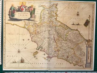
Historic Antique Vintage Colour Blaeu Map Of Greece, Europe 1640 1600 ' S: REPRINT


Item History & Price

Information:
Reference Number: Avaluer:28832399Cartographer/Publisher: Blaeu
Date Range: 1600-1699Original/Reproduction: Antique Reproduction
Country/Region: GreeceType: County Map
Era: 1600sYear: 1640
Original Description:
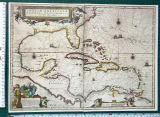
Map of Greece, Europe which was originally published in 1640 by William Blaeu who was a Dutch mapmaker. 
This map is a book plate taken very carefully from a book of 17th Century maps which was published in 1997.  It is printed on good quality paper but as it is from a book it is on 2 separate pieces of paper. The join between the 2 pages is very good, check the photos for more details.  It measures approximately 44cm x 35cm and would look fabulous framed.A detailed d...escription of the map is included with the map.   PLEASE NOTE THAT THIS MAP IS NOT a PHOTOCOPY! 
The map has been kept in a sealed plastic bag and will be sent to you in a cardboard backed envelope.I have other maps for sale and will combine postage prices if you wish to buy any others.


    Similar items


  • Historic Antique Vintage Colour Blaeu Map Of Tuscany,  Italy 1640 1600

    Historic Antique Vintage Colour Blaeu Map Of Tuscany, Italy 1640 1600 ' S: Reprint

  • Historic Old Antique Vintage Vignette Blaeu Map Of Africa 1617 1600

    Historic Old Antique Vintage Vignette Blaeu Map Of Africa 1617 1600 ' S: Reprint

  • Antique Vintage Tudor Blaeu Map Of Guinea,  West Africa 1635 1600

    Antique Vintage Tudor Blaeu Map Of Guinea, West Africa 1635 1600 ' S: Reprint

  • Antique Vintage Tudor Blaeu Map Of Montgomery,  Merioneth,  Wales 1600

    Antique Vintage Tudor Blaeu Map Of Montgomery, Merioneth, Wales 1600 ' S: Reprint

  • Antique Vintage Old Blaeu Map Of The Caribbean 1600

    Antique Vintage Old Blaeu Map Of The Caribbean 1600 ' S Reprint 1634 South America

  • Old Antique Vintage Tudor Blaeu Map Of Monmouthshire,  Wales 1665 1600

    Old Antique Vintage Tudor Blaeu Map Of Monmouthshire, Wales 1665 1600 ' S: Reprint

  • Old Antique Vintage Tudor Blaeu Map Of Essex England 1600

    Old Antique Vintage Tudor Blaeu Map Of Essex England 1600 ' S: Reprint 18. 5 " X 13


    • You might also like


    • Hungary & Romania 1579 (1584) Ortelius Unusual Antique Copper Engraved Map

      Hungary & Romania 1579 (1584) Ortelius Unusual Antique Copper Engraved Map

    • Brussels Bruxelles Belfium 1777 De Ferraris & Dupuis Large Antique Map Sheet Xxi

      Brussels Bruxelles Belfium 1777 De Ferraris & Dupuis Large Antique Map Sheet Xxi

    • 1616 Atlas Map Of Iceland.

      1616 Atlas Map Of Iceland.

    • Kazan Russia 1767 Le Clerc/lespinasse Antique Copper Engraved City View

      Kazan Russia 1767 Le Clerc/lespinasse Antique Copper Engraved City View

    • 1899 Stanford,  Folding Map Of Norwich,  Norfolk,  Arthur Collins,  Jarrold & Sons,

      1899 Stanford, Folding Map Of Norwich, Norfolk, Arthur Collins, Jarrold & Sons,

    • 1948 Vintage Linen Colour Map Geological Survey Ten Mile Of Great Britain

      1948 Vintage Linen Colour Map Geological Survey Ten Mile Of Great Britain

    • 1944 Map Flying Bombs Sussex Ww2 Newspaper Military Kent Courier German V1 V2

      1944 Map Flying Bombs Sussex Ww2 Newspaper Military Kent Courier German V1 V2

    • Dated 1638 Vellum Map Of Icklesham Sussex Showing Land Uses Owners Etc

      Dated 1638 Vellum Map Of Icklesham Sussex Showing Land Uses Owners Etc

Avaluer          About Us          Privacy Policy          Contact Us          UP
© 2022, avaluer.net, Inc. or its affiliates