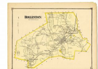
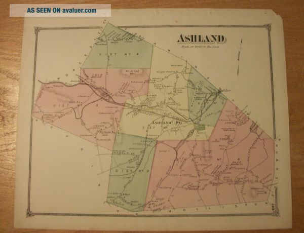
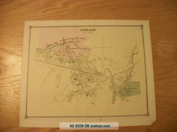
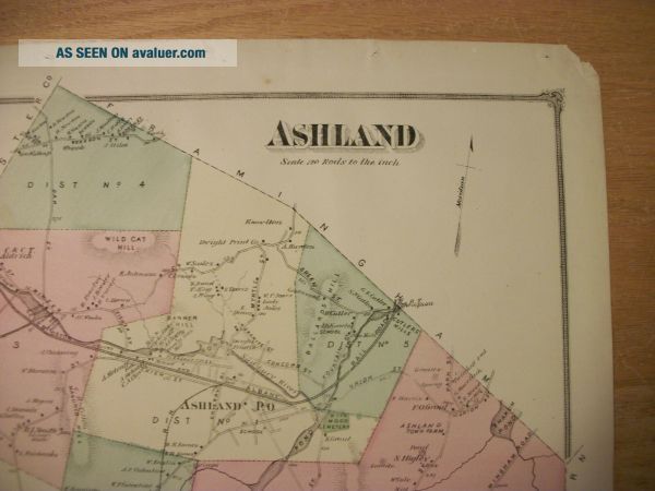
1875 Map Of Ashland MA From Beers ' Atlas Of Middlesex County With Family Names


Item History & Price

Information:
Reference Number: Avaluer:30463424Original/Reproduction: Original
Maker: F. W. BeersType: Map
Publication Year: 1875Year: 1875
Original Description:
Antique map of Ashland, Massachusetts, from the F.W. Beers' Atlas of Middlesex County, published in 1875. Plate 140. Hand colored. Approx. 14 by 16.5 inches. Excellent condition. The village map is on the reverse of the town map. The town map shows the whole town of Ashland, with property owners' names on most houses outside of the central village. The central village of Ashland is shown on the reverse side of the town map and shows property owners' names on most houses in the central ...village. The town map also shows Ballards Hill, Boston & Albany Railroad, Cold Spring Brook, Soap Stone Quarry, Holliston Town Farm, Springs, Sudbury River, Woolen Mill, Aldrich's Mills, Dwight Print Co., Wild Cat Hill, Schoolhouses, Town Hall, Wildwood Cemetery, Cutler's Mills, Ashland Town Farm, Shakum Pond, Living Spring, Granite Quarry, Mills, etc.The village map shows Lands and Buildings of the Dwight Printing Co., Cold Spring Pond, Wildwood Cemetery, etc/.Approximately 16.5 inches by 14 inches. Hand colored. A great gift for anyone who is interested in the history and genealogy of Ashland!

01087


    Similar items


  • 1875 Map Of Holliston,  Mass.  From Beers Atlas Of Middlesex County W/family Names

    1875 Map Of Holliston, Mass. From Beers Atlas Of Middlesex County W/family Names

  • Old Map Of Westfield,  Ma From 1875 - Vintage Massachusetts Art,  Historic Decor

    Old Map Of Westfield, Ma From 1875 - Vintage Massachusetts Art, Historic Decor

  • 1867 Antique Map Of Wolcott,  Connecticut,  From Beers Atlas Framed

    1867 Antique Map Of Wolcott, Connecticut, From Beers Atlas Framed

  • Map Of Livingston,  Ny,  From Beers

    Map Of Livingston, Ny, From Beers ' Columbia County Atlas 1873, W/family Names

  • 1878 Map Of Cambridge,  Vermont,  From Beers

    1878 Map Of Cambridge, Vermont, From Beers ' Atlas Of Lamoille & Orleans Counties

  • Old Map Of Webster,  Ma From 1892 - Vintage Massachusetts Art,  Historic Decor

    Old Map Of Webster, Ma From 1892 - Vintage Massachusetts Art, Historic Decor

  • 1875 Map Of Cabot,  Vermont From Atlas Of Caledonia County W/family Names

    1875 Map Of Cabot, Vermont From Atlas Of Caledonia County W/family Names

  • Rare 1939 Brochure 2 Maps Of Boston Ma From The Hotel Statler Scarce & Colorful

    Rare 1939 Brochure 2 Maps Of Boston Ma From The Hotel Statler Scarce & Colorful


    • You might also like


    • 1860 Mitchell Hand Colored Map Colorado,  Nebraska & Kansas - Civil War Era

      1860 Mitchell Hand Colored Map Colorado, Nebraska & Kansas - Civil War Era

    • 18th Century French Map Of North America

      18th Century French Map Of North America

    • Las Vegas Nevada Vintage 1967 Us Geological Survey Quadrangle Map 4 Panels

      Las Vegas Nevada Vintage 1967 Us Geological Survey Quadrangle Map 4 Panels

    • Rare Antique 1845 Maps United States Exploring Expedition Book Antartica Hawaii

      Rare Antique 1845 Maps United States Exploring Expedition Book Antartica Hawaii

    • Vintage 1926 Map Hollywood From The Best Surveys Of The Time

      Vintage 1926 Map Hollywood From The Best Surveys Of The Time

    • American Continent (western Hemisphere) 1747 Bowen Antique Copper Engraved Map

      American Continent (western Hemisphere) 1747 Bowen Antique Copper Engraved Map

    • Gulf Coast Florida Texas United States 1705 De Fer Unusual Antique Engraved Map

      Gulf Coast Florida Texas United States 1705 De Fer Unusual Antique Engraved Map

    • California As Island United States 1700 De Fer Unusual First Edition Antique Map

      California As Island United States 1700 De Fer Unusual First Edition Antique Map

Avaluer          About Us          Privacy Policy          Contact Us          UP
© 2022, avaluer.net, Inc. or its affiliates