Antique Map - USA - VIRGINIA - NORTH CAROLINA - SOUTH - GEORGIA - Bonne - C. 1780
Item History & Price
The Prints Collector
Original Antique Maps and PrintsABOUT USVISIT OUR STOREAntique Map-USA-VIRGINIA-NORTH CAROLINA-SOUTH-GEORGIA-Bonne-c. 1780
Description: Source unknown, to be determined.
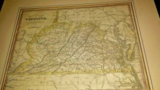
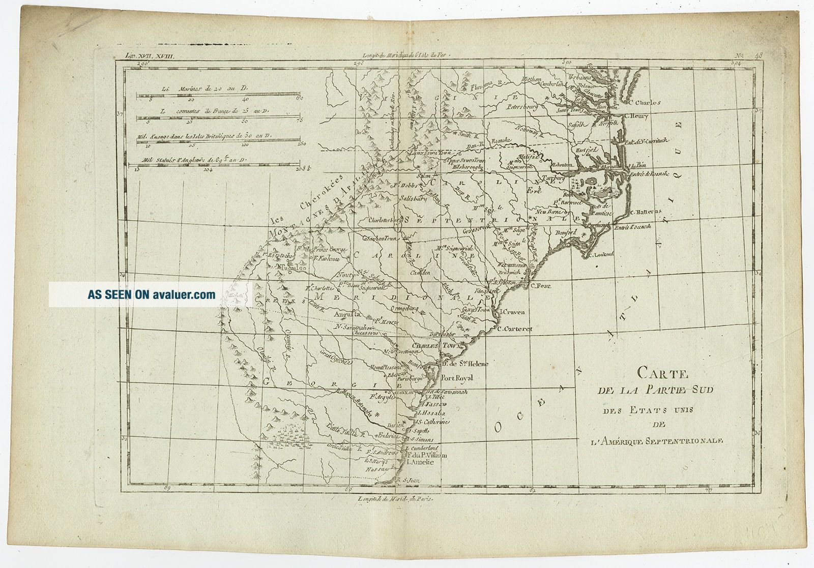
Artists and Engravers: Made by 'Rigobert Bonne' after an anonymous artist. Rigobert Bonne (1727-1795 ) was one of the most important cartographers of the late 18th century. In 1773 he succeeded Jacques Bellin as Royal Cartographer to France in the office of the Hydrographer at the ...Depôt de la Marine. Working in his official capacity Bonne compiled some of the most detailed and accurate maps of the period. Bonne's work represents an important step in the evolution of the cartographic ideology away from the decorative work of the 17th and early 18th century towards a more detail oriented and practical aesthetic. With regard to the rendering of terrain Bonne maps bear many stylistic similarities to those of his predecessor, Bellin. However, Bonne maps generally abandon such common 18th century decorative features such as hand coloring, elaborate decorative cartouches, and compass roses. While mostly focusing on coastal regions, the work of Bonne is highly regarded for its detail, historical importance, and overall aesthetic appeal.Subject: Antique map, titled: 'Carte de la Partie Sud des Etats Unis de l'Amerique Septentrionale.' - This map covers the states of Virginia, North and South Carolina, and Georgia in the new United States. All settlement is confined east of the Appalachians with les Cherokees the only note in the otherwise blank region west of the mountains. There are four distance scales located on the left side of the map.
Condition: Good, given age. Slight discolouration near middle fold. A few minor spots. Light crease lower right. Sharp crease top left, not affecting image. Original middle fold as issued. General age-related toning and/or occasional minor defects from handling. Please study scan carefully.
Size (in cm): The overall size is ca. 38 x 26 cm. The image size is ca. 31 x 21.5 cm.
Size (in inch): The overall size is ca. 15 x 10.2 inch. The image size is ca. 12.2 x 8.5 inch.
Medium: Copperplate engraving / etching on hand laid (verge) paper.
Location: (ISCRA) BG-B16-42
ThePrintsCollector - Laurentius Old Master Prints
Frans Laurentius, Peter Cornelissen
Margo van Latum-van Dongen, Frank van Latum
Located in Zeeland (Noord-Brabant) - The Netherlands
Worldwide free shipping on all orders.
We ship within three business days upon receipt of payment.
We ship by registered mail.
GO TO OUR STORE and explore our huge collection of fine antique maps and prints. We only accept payments via Paypal.
Combined orders are possible! We will send a Paypal invoice on request!
THE PRINTSCOLLECTOR GUARANTEES ITEMS SOLD THROUGH EBAY ARE GENUINE ORIGINAL
ANTIQUE PRINTS IN THE CONDITION/TECHNIC AS DESCRIBED. ITEMS CAN BE RETURNED WITHIN 30 DAYS.
Original Antique Maps and PrintsABOUT USVISIT OUR STOREAntique Map-USA-VIRGINIA-NORTH CAROLINA-SOUTH-GEORGIA-Bonne-c. 1780
Description: Source unknown, to be determined.
Artists and Engravers: Made by 'Rigobert Bonne' after an anonymous artist. Rigobert Bonne (1727-1795 ) was one of the most important cartographers of the late 18th century. In 1773 he succeeded Jacques Bellin as Royal Cartographer to France in the office of the Hydrographer at the ...Depôt de la Marine. Working in his official capacity Bonne compiled some of the most detailed and accurate maps of the period. Bonne's work represents an important step in the evolution of the cartographic ideology away from the decorative work of the 17th and early 18th century towards a more detail oriented and practical aesthetic. With regard to the rendering of terrain Bonne maps bear many stylistic similarities to those of his predecessor, Bellin. However, Bonne maps generally abandon such common 18th century decorative features such as hand coloring, elaborate decorative cartouches, and compass roses. While mostly focusing on coastal regions, the work of Bonne is highly regarded for its detail, historical importance, and overall aesthetic appeal.Subject: Antique map, titled: 'Carte de la Partie Sud des Etats Unis de l'Amerique Septentrionale.' - This map covers the states of Virginia, North and South Carolina, and Georgia in the new United States. All settlement is confined east of the Appalachians with les Cherokees the only note in the otherwise blank region west of the mountains. There are four distance scales located on the left side of the map.
Condition: Good, given age. Slight discolouration near middle fold. A few minor spots. Light crease lower right. Sharp crease top left, not affecting image. Original middle fold as issued. General age-related toning and/or occasional minor defects from handling. Please study scan carefully.
Size (in cm): The overall size is ca. 38 x 26 cm. The image size is ca. 31 x 21.5 cm.
Size (in inch): The overall size is ca. 15 x 10.2 inch. The image size is ca. 12.2 x 8.5 inch.
Medium: Copperplate engraving / etching on hand laid (verge) paper.
Location: (ISCRA) BG-B16-42
ThePrintsCollector - Laurentius Old Master Prints
Frans Laurentius, Peter Cornelissen
Margo van Latum-van Dongen, Frank van Latum
Located in Zeeland (Noord-Brabant) - The Netherlands
Worldwide free shipping on all orders.
We ship within three business days upon receipt of payment.
We ship by registered mail.
GO TO OUR STORE and explore our huge collection of fine antique maps and prints. We only accept payments via Paypal.
Combined orders are possible! We will send a Paypal invoice on request!
THE PRINTSCOLLECTOR GUARANTEES ITEMS SOLD THROUGH EBAY ARE GENUINE ORIGINAL
ANTIQUE PRINTS IN THE CONDITION/TECHNIC AS DESCRIBED. ITEMS CAN BE RETURNED WITHIN 30 DAYS.