1834 S. D. U. K. Subscriber ' S Edition Map Or Plan Of St. Petersburg, Russia
Item History & Price
| Reference Number: Avaluer:41551 |
1834 S.D.U.K. Subscriber's Edition Map or Plan of St. Petersburg, Russia
WE SELL ONLY ORIGINAL ANTIQUE MAPS - NOT REPRODUCTIONS
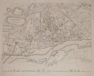
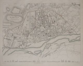
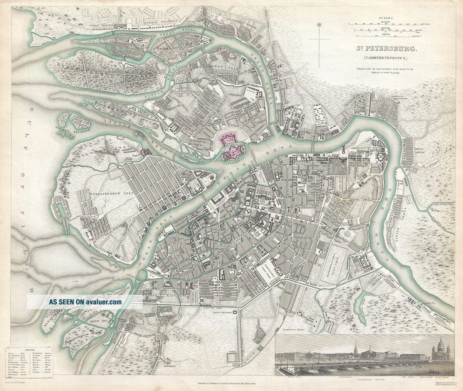
Title: St. Petersburg [CAHKTIIETEPBYPTA].
Description: This is a scarce 1834 map or city plan of St. Petersburg, Russia, published by the Society for the Diffusion of Useful Knowledge. It covers the second largest city in Russia located on the Zayachii Ostrov in the Neva River. St. Petersburg was Imperial capital of Russia from 173...2–1918. Centered on the Peter and Paul Fortress, the map shows fine engraved detail including individual streets, houses, cemeteries, rivers, streams, churches, bridges and beautifully rendered parks and fields. A panoramic view shows the city with the Isakiefskoi Bridge in the foreground. The map also identifies the Winter Palace, Admiralty, War Office, Statue of Peter I, and Isaac's Church.
This map was part of A Series of Maps, Modern and Ancient, issued by subscription by the SDUK. Each folder in the series would contain a set of two maps bound together. The map accompanying this folder, not included here, was of Edinburg, London. The original folder included the names of committee members of the ‘Society’, notices to subscribers, the folder number, which is this case was XLVIII, the contents and the printer and publication details.
This map was printed by William Clowes and issued by the Society for the Diffusion of Useful Knowledge in their March 1834 subscriber’s edition folder and published by Baldwin and Cradock. The folder at the time was priced at 1 shilling plain or 1 shilling 6 pence colored.
Size: Printed area measures 14 inches high by 15.5 inches wide.
Condition: Very good. Even overall toning. Light soiling. Blank on verso.
Shipping: Shipping rates are not negotiable. Items are shipped within three business days of receiving payment. We are happy to consolidate shipping where possible. The following shipping options are available: 1. FedEx Overnight (45 USD). USA Only. Signature Required.
2. FedEx Ground or Home Delivery (15 USD). USA Only. 1 - 10 days. If your address is a P.O. Box and cannot ship FedEx we will ship USPS Priority and, while we ship promptly, recent postal personnel cutbacks mean that delivery may take time. Signature Required.
3. FedEx International or DHL International EXPRESS (45 USD).
4. We can use your FedEx Account.
Customs: International buyers are responsible for paying duty and taxes on delivery. DHL or FedEx will contact the buyer by telephone to arrange tax payment if it is levied. Duty varies by country and we cannot predict the amount you will be charged. Some countries are duty free, others are not. Typically, a customs duty and/or VAT tax will be assessed on all parcels to continental Europe. Sometimes duty or tax is due in China, but is seems very random. Hong Kong, Singapore, Korea, and Taiwan have never assessed duty on a map we shipped. Maps shipped to the UK should be duty free as educational materials, but from time to time duty of 5% is assessed incorrectly by the UK customs agents.
Insurance: All shipments are insured privately against loss and damage. All of our shipments require a signature for insurance purposes.
If you have any questions please feel free to email us through eBay.
Other ServicesConservation Framing: Geographicus recommends basic conservation framing services for any antique paper. We do not offer this service.
Antique Map Restoration: Geographicus can repair and restore your antique map. Services include deacidification cleaning flattening and backing.
BEWARE anyone attempting to contact you, from a different eBay account, claiming to represent Geographicus Antique Maps. My eBay handle is GeographicusMaps. If you are contacted by email by someone offering you my items, please call me directly to be certain you are not dealing with a con artist. "