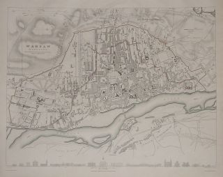
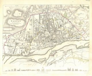
Antique Map, Warsaw / Warszawa S. D. U. K. C. 1831


Item History & Price

Information:
Reference Number: Avaluer:10776Map Type: Countries/Borders, Geological/Terrain, Historical/Political
Colouring: Hand TintedFormat: Sheet Map
Original/Repro: OriginalCountry/Region: England
Age: Pre-1800
Original Description:
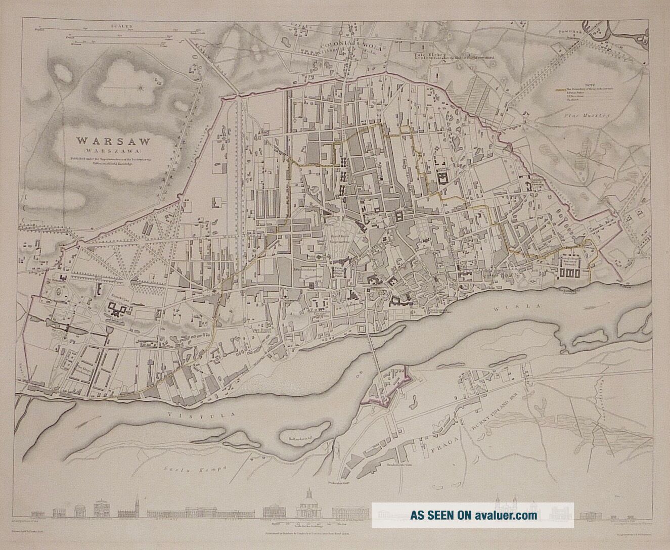
Title: Warsaw / Warszawa Description:A bird's eye view of Warsaw towards the end of 1831. This map was published by Baldwin & Craddock c. 1831. Below the lower neatline is a series of 15 profiles of prominent buildings.Publication: Society for the Diffusion of Useful Knowledge (S.D.U.K.) c. 1831Condition: Very good. Color: Partially coloured. Minor tears, if any, have been mended with archival tissue. The attached photo is part of the item description, pleas...e examine carefully.Size (h x w): 29.3 x 37.2 cm, (neat line)Technique: Lithographic Engraver: T E Nicholson Ref: JJB2770
Powered by eBay Turbo Lister


    Similar items


  • Antique Map,  Warsaw / Warszawa S.  D.  U.  K.  C.  1842

    Antique Map, Warsaw / Warszawa S. D. U. K. C. 1842

  • Antique Map,  Poland,  Warsaw / Warszawa,  S.  D.  U.  K.  Nov.  1831

    Antique Map, Poland, Warsaw / Warszawa, S. D. U. K. Nov. 1831

  • 1844 China Large Hand Coloured Antique Map From Johnston

    1844 China Large Hand Coloured Antique Map From Johnston ' S National Atlas

  • 1844 North America Texas Republic Antique Map From Johnston

    1844 North America Texas Republic Antique Map From Johnston ' S National Atlas

  • 1844 United States & Texas Republic Antique Map From Johnston

    1844 United States & Texas Republic Antique Map From Johnston ' S National Atlas

  • Antique Map,  The Queen

    Antique Map, The Queen ' S Palace, Formerly Buckingham House In St. James ' S Park

  • Glocestershire 1695 Robert Morden Antique Map From Camden

    Glocestershire 1695 Robert Morden Antique Map From Camden ' S Britannia

  • Oxford 1695 Robert Morden Antique Map From Camden

    Oxford 1695 Robert Morden Antique Map From Camden ' S Britannia 1695


    • You might also like


    • Hungary & Romania 1579 (1584) Ortelius Unusual Antique Copper Engraved Map

      Hungary & Romania 1579 (1584) Ortelius Unusual Antique Copper Engraved Map

    • Brussels Bruxelles Belfium 1777 De Ferraris & Dupuis Large Antique Map Sheet Xxi

      Brussels Bruxelles Belfium 1777 De Ferraris & Dupuis Large Antique Map Sheet Xxi

    • 1616 Atlas Map Of Iceland.

      1616 Atlas Map Of Iceland.

    • Kazan Russia 1767 Le Clerc/lespinasse Antique Copper Engraved City View

      Kazan Russia 1767 Le Clerc/lespinasse Antique Copper Engraved City View

    • 1899 Stanford,  Folding Map Of Norwich,  Norfolk,  Arthur Collins,  Jarrold & Sons,

      1899 Stanford, Folding Map Of Norwich, Norfolk, Arthur Collins, Jarrold & Sons,

    • 1948 Vintage Linen Colour Map Geological Survey Ten Mile Of Great Britain

      1948 Vintage Linen Colour Map Geological Survey Ten Mile Of Great Britain

    • 1944 Map Flying Bombs Sussex Ww2 Newspaper Military Kent Courier German V1 V2

      1944 Map Flying Bombs Sussex Ww2 Newspaper Military Kent Courier German V1 V2

    • Dated 1638 Vellum Map Of Icklesham Sussex Showing Land Uses Owners Etc

      Dated 1638 Vellum Map Of Icklesham Sussex Showing Land Uses Owners Etc

Avaluer          About Us          Privacy Policy          Contact Us          UP
© 2022, avaluer.net, Inc. or its affiliates