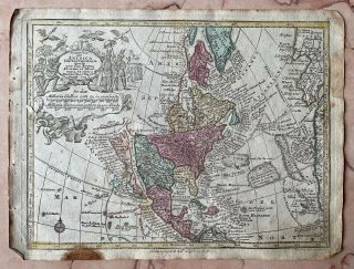
AMERICA CALIFORNIA AS AN ISLAND 1656 NICOLAS SANSON VERY RARE LARGE ANTIQUE MAP


Item History & Price

Information:
Reference Number: Avaluer:42508143Cartographer/Publisher: Nicholas Sanson
US State: CaliforniaPrinting Technique: Copper Plate
Date Range: 1600-1699Original/Reproduction: Antique Original
Country/Region: United States of AmericaYear: 1656
Original Description:


Title of the map:

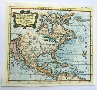
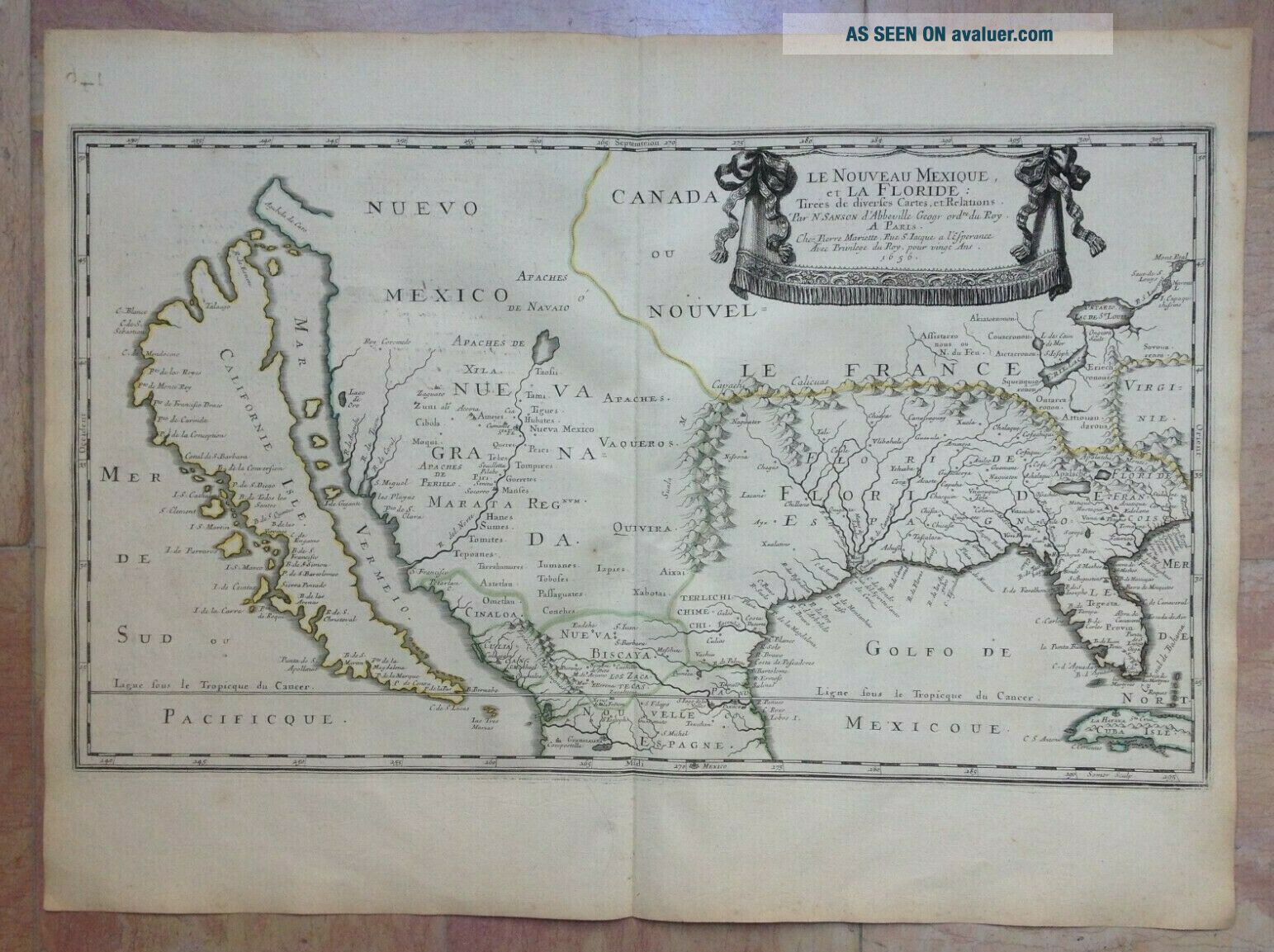
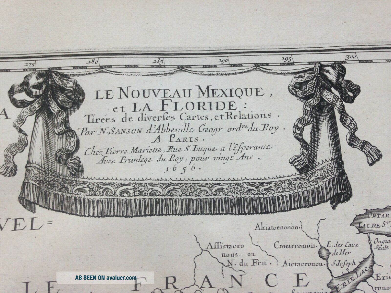
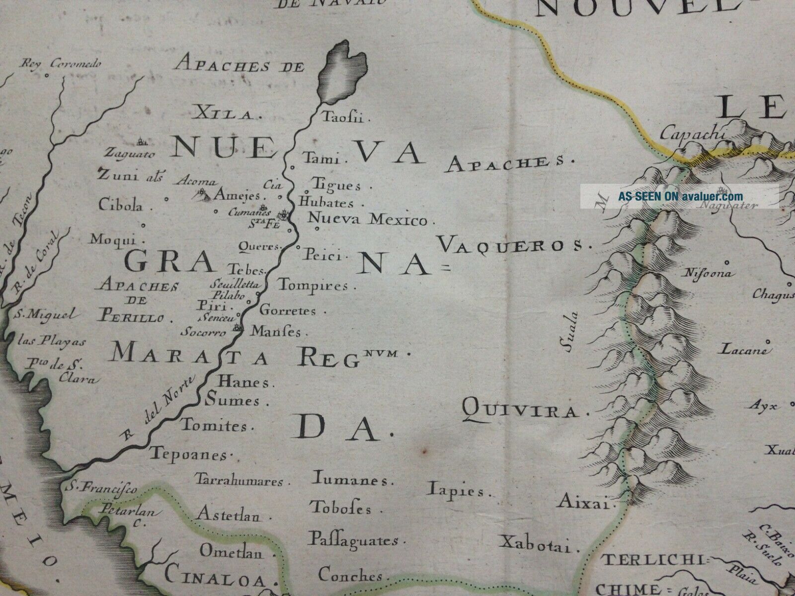
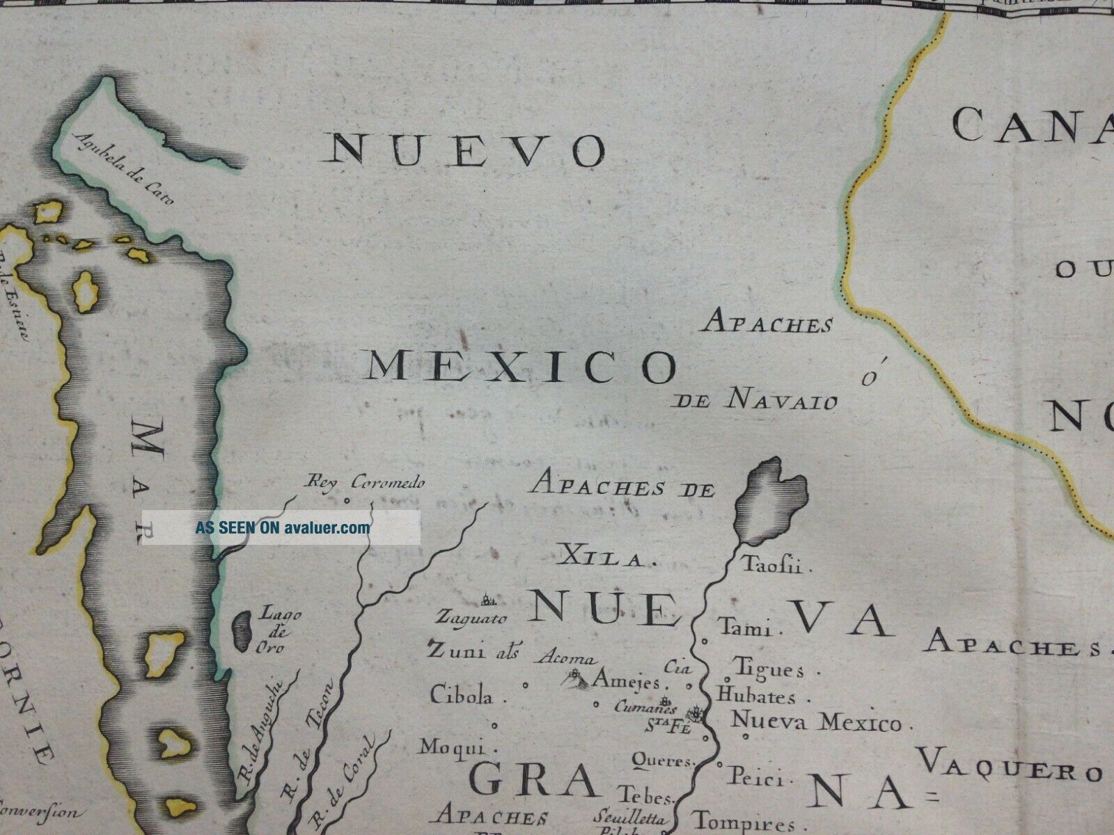
"LE NOUVEAU MEXIQUE et LA FLORIDE Tirées de diverses Cartes et Relations, Par N. SANSON d'Abbeville Geogr Ord du Roy, A PARIS, Chez Pierre Mariette Rue S. Iacques a l'Esperance, Avec Privilege du Roy, pour vingt Ans 1656". 
Very unusual copper engraved map of North America, by Nicolas SANSON D'ABBEVILLE (1600-1667).The map is engraved by Jean Somer.First state (cf. Burden): 1656, with the imprint "Chez Pierre Mariette, Rue S. Iacque...1656"
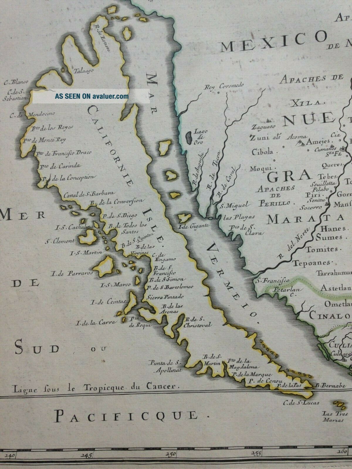
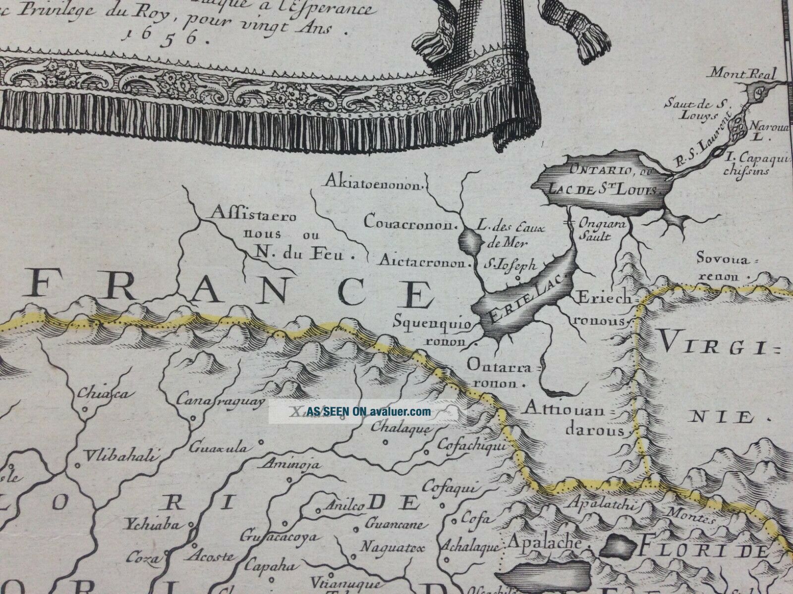
...California is shown as an island. The first map to show California so detailed, and to show the Spanish territories from California to Florida.The lake ERIE is well shown for the first time.This is a very important map, the first in a printed atlas to put the greatest emphasis on California and New Mexico. A map of great influence, it became the model for the delineation of California for the next fifty years. In this map Sanson changed the place names from French into Spanish, and altered the shape of the island giving it an indented Northern Coastline.  The place names, from North to South, are:R. de Estiete, Talaago, C. Blanco, C de Sebatian, C de Mendocino, Pto de los Reyes, Pto de Monte Rey, Pto de Francisco Draco, Pto de Carinda, P de la Conception, Canal de S Barbara, B de la Conversion, P de S Diego, I. S. Cathalina, B de Todos los Santos, S Clement, I S Martin, B de S Quintin, B de la Virgines, C de Engamo, I de Parraros, B de S Francisco, I.S. Marco, B de S. Simon, P de S Bartolomeo, I de Ceintas, Sierra Pintado, B de les Arenas, I de la Carre, Pta de Roqui, R de S Cristoval, Punta de S Apollinat, B de S Martin, Pto de la Magdalena, P de la Marque, P de Cenou, P de la Pas, B Bernabe, C de S Lucas.   

On back, 14 lines of antique handwritten text in Old French, of the same period, describing the map.
Active from 1627, Sanson published its first major map, the Postes de France, in 1632, with the publisher Melchior Tavernier. After having published a few general atlases alone, he worked with the print editor Pierre Mariette.

Edition: Paris, chez Pierre Mariette rue S. Iacques à l'Espérance, Avec Privilege du Roy pour Vingt Ans, 1656, XVIIe Century.
Size with margins : 57, 4 x 42, 4 cm / 22, 4 x 16, 5 inches
Condition : very good condition, antique colors, large margins

If you buy more than one item, you will pay only one shipping cost.All shipments are insured. We send map sby DHL.
WE DON'T SELL LASER AND COPIES MAPS, ALL WE SELL IS ORIGINAL AND ANTIQUEDue to the age an type of paper, some imperfections are to be expected. Please examine the images provided carefully, and if you have any questions please ask and we will be happy to help you


    Similar items


  • North America California As An Island 1735 Nicolas Sanson Unusual Antique Map

    North America California As An Island 1735 Nicolas Sanson Unusual Antique Map

  • North America California As An Island By John Senex C1740 Antique Map

    North America California As An Island By John Senex C1740 Antique Map

  • 1697 Philip Cluver Map America California As An Island Coloring

    1697 Philip Cluver Map America California As An Island Coloring

  • Rare 1730 North America (california As An Island) Map Johann Baptist Homann

    Rare 1730 North America (california As An Island) Map Johann Baptist Homann

  • Antique Map 1770 North America California As An Island Mexico Seutter

    Antique Map 1770 North America California As An Island Mexico Seutter

  • America (california As An Island) 1730 Matheus Seutter Large Antique Map 18th C.

    America (california As An Island) 1730 Matheus Seutter Large Antique Map 18th C.

  • Robert Seal Vtg 1734 Hand Colored Map Of North America California As An Island

    Robert Seal Vtg 1734 Hand Colored Map Of North America California As An Island

  • Extremely Rare.  H.  Moll “america” - California As An Island 1700’s Antique Map

    Extremely Rare. H. Moll “america” - California As An Island 1700’s Antique Map


    • You might also like


    • 1860 Mitchell Hand Colored Map Colorado,  Nebraska & Kansas - Civil War Era

      1860 Mitchell Hand Colored Map Colorado, Nebraska & Kansas - Civil War Era

    • 18th Century French Map Of North America

      18th Century French Map Of North America

    • Las Vegas Nevada Vintage 1967 Us Geological Survey Quadrangle Map 4 Panels

      Las Vegas Nevada Vintage 1967 Us Geological Survey Quadrangle Map 4 Panels

    • Rare Antique 1845 Maps United States Exploring Expedition Book Antartica Hawaii

      Rare Antique 1845 Maps United States Exploring Expedition Book Antartica Hawaii

    • Vintage 1926 Map Hollywood From The Best Surveys Of The Time

      Vintage 1926 Map Hollywood From The Best Surveys Of The Time

    • American Continent (western Hemisphere) 1747 Bowen Antique Copper Engraved Map

      American Continent (western Hemisphere) 1747 Bowen Antique Copper Engraved Map

    • Gulf Coast Florida Texas United States 1705 De Fer Unusual Antique Engraved Map

      Gulf Coast Florida Texas United States 1705 De Fer Unusual Antique Engraved Map

    • California As Island United States 1700 De Fer Unusual First Edition Antique Map

      California As Island United States 1700 De Fer Unusual First Edition Antique Map

Avaluer          About Us          Privacy Policy          Contact Us          UP
© 2022, avaluer.net, Inc. or its affiliates